Garfield, Kentucky
Garfield is an unincorporated community in Breckinridge County, Kentucky, United States.[2]
Garfield, Kentucky | |
|---|---|
 Garfield | |
| Coordinates: 37°46′58″N 86°21′27″W | |
| Country | United States |
| State | Kentucky |
| County | Breckinridge |
| Elevation | 804 ft (245 m) |
| Time zone | UTC-6 (Central (CST)) |
| • Summer (DST) | UTC-5 (CDT) |
| ZIP code | 40140[1] |
| Area code(s) | 270 |
| GNIS feature ID | 492703[2] |
A post office was established in the community in 1880 and named for candidate and future president James A. Garfield.[3] A previous post office had been in the community from 1862 to 1866 and was known as Prince of Wales, Kentucky with the post master being Hopkins D. Wales. The community had asphalt mines, an inn, churches and a stage coach stop. Abraham Lincoln stayed at the inn as a child in 1816 when the family was moving to Indiana. According to tradition, the slaves at the inn refused to eat with the poor white trash Lincoln.[4]
The community sits at the junction of U.S. Highway 60 and Kentucky Route 86.
References
- United States Postal Service (2012). "USPS - Look Up a ZIP Code". Retrieved 2012-02-15.
- "Garfield". Geographic Names Information System. United States Geological Survey.
- Rennick, Robert M. (1987). Kentucky Place Names. University Press of Kentucky. p. 113. ISBN 0813126312. Retrieved 2013-04-28.
- "Breckinridge County (Rennick Collection)". Morehead State University. Retrieved January 13, 2021.
Municipalities and communities of Breckinridge County, Kentucky, United States | ||
|---|---|---|
| Cities | 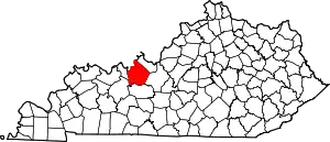 Location of Breckinridge County, Kentucky | |
| Unincorporated communities | ||
| Footnotes | ‡This populated place also has portions in an adjacent county or counties | |
| ||
This article is issued from Wikipedia. The text is licensed under Creative Commons - Attribution - Sharealike. Additional terms may apply for the media files.
