Geelong city centre
The Geelong city centre is a locality surrounded by the Geelong metropolitan area. It is also referred to as the Geelong CBD, Central Geelong,[2] or the Central Activities Area,[3] and informally simply as "town" by locals. The name of the area is officially gazetted as Geelong.[4]
| Geelong Geelong, Victoria | |||||||||||||||
|---|---|---|---|---|---|---|---|---|---|---|---|---|---|---|---|
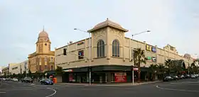 Corner of Moorabool and Malop Streets, Geelong | |||||||||||||||
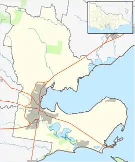 Geelong | |||||||||||||||
| Coordinates | 38°09′35″S 144°21′52″E | ||||||||||||||
| Population | 5,210 (2016 census)[1] | ||||||||||||||
| Postcode(s) | 3220 | ||||||||||||||
| LGA(s) | City of Greater Geelong | ||||||||||||||
| State electorate(s) | Geelong | ||||||||||||||
| Federal Division(s) | Corio | ||||||||||||||
| |||||||||||||||
It is the oldest part of Geelong and includes many of the city's historic landmarks such as the Geelong Town Hall, St. Mary of the Angels Basilica, the T & G Building, Johnstone Park, Geelong railway station, and the old Geelong Post Office.
The area is one of Geelong's major shopping districts. Two shopping malls, Westfield Geelong and Market Square Shopping Centre, have been opened in the last three decades, which has led to a decline in strip shopping on the city's two main thoroughfares, Moorabool Street and Ryrie Street, resulting in a declining number of customers and some empty shops.[5]
The city centre is also a cultural area for the region, housing the Geelong Art Gallery and the Geelong Arts Centre, as well as the Deakin University waterfront campus. Tourist attractions include the Waterfront Geelong, Eastern Beach, and the National Wool Museum.
The Geelong City Centre has seen some significant redevelopment since 2016. In 2018, the Worksafe office building was opened, followed by the National Disability Insurance Agency (NDIA) national headquarters in 2019,[6] significantly altering the skyline. New multi-storey apartment buildings, such as The Mercer and The Miramar, have also been built recently.
Population
In the 2016 Census, there were 5,210 people living in the Geelong city centre. 69.5% of people were born in Australia. The next most common countries of birth were England 3.1%, India 2.7%, Italy 2.0% and China 1.9%. 75.5% of people spoke only English at home. Other languages spoken included Italian 2.8% and Mandarin Chinese 2.4%. The most common responses for religion were No Religion 33.1% and Catholic 26.0%.[1]
References
- Australian Bureau of Statistics (27 June 2017). "Geelong (State Suburb)". 2016 Census QuickStats.

- City of Greater Geelong: Central Geelong revitalisation
- City of Greater Geelong: Central Geelong Activities Area
- "City of Greater Geelong Suburb and Rural District Names and Boundaries" (PDF). Department of Transport, Planning and Local Infrastructure. State Government of Victoria. May 2013. Retrieved 16 May 2015.
- Sophie Smith (2 July 2008). "While Moorabool St remains cold and empty". Geelong News. p. 3.
- "Doors open to new National Disability Insurance Agency national office in Geelong". National Disability Insurance Agency. Retrieved 15 September 2020.