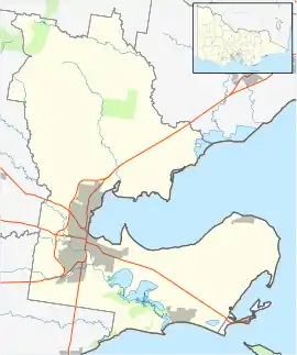
Mount Duneed, Victoria
Mount Duneed is a suburb of Geelong, Victoria, Australia. It is divided between the City of Greater Geelong and Surf Coast Shire local government areas. Mount Duneed itself is an extinct volcano and the remains of the crater can be seen in the Mount Duneed Recreation Reserve.[2]
| Mount Duneed Geelong, Victoria | |||||||||||||||
|---|---|---|---|---|---|---|---|---|---|---|---|---|---|---|---|
 Mount Duneed | |||||||||||||||
| Coordinates | 38°13′55″S 144°18′13″E | ||||||||||||||
| Population | 1,578 (2016 census)[1] | ||||||||||||||
| Postcode(s) | 3217 | ||||||||||||||
| Location | |||||||||||||||
| LGA(s) | |||||||||||||||
| State electorate(s) | South Barwon | ||||||||||||||
| Federal Division(s) | Corangamite | ||||||||||||||
| |||||||||||||||
Much of the locality north of Lower Duneed Road is part of the large Armstrong Creek Growth Area, which was opened up for urban development from 2010. With the gazetting of the suburb Armstrong Creek in February 2012, Mount Duneed's southern boundary between Surf Coast Highway and Horseshoe Bend Road follows the boundary of the Armstrong Creek Urban Growth Area. The area north of Boundary Road, south of the Warrnambool railway line and west of the Surf Coast Highway, formerly part of Grovedale, became part of Mount Duneed.[3][4][5]
History
European settlement
In 1852, squatter John Armstrong leased a station in the Mount Duneed area. The station covered 16 square miles and Armstrong's homestead was on the east side of Surf Coast Highway.
Between 1847 and 1850 Assistant Surveyor William Pickering began work mapping the Duneed Parish and lots of c. 640 acres became available for purchase. The large size of the blocks resulted in few sales and Armstrong continued to graze livestock over the area. In 1854, the land comprising Armstrong's River Station was again surveyed and subdivided for sale. Armstrong retained 320 acres on the east side of Surf Coast Highway and renamed his run River Station.[6]
Summerhill - a prefabricated iron cottage erected in 1854 is listed on the Victorian Heritage Register.[7]
The Post Office opened on 15 February 1860, but was known as Connewarre for some months then Puelba until 1864. It was renamed Mount Duneed on 1 April 1864. It closed in 1959.[8]
Duneed Aboriginal Land Reserve
From 1861 to 1907, the Duneed Aboriginal Land Reserve, located was located on Ghazeepore Road just south of Andersons Creek, functioned as an Aboriginal reserve.
21st century
The Geelong Airport was located in the now-excised portion of Mount Duneed, but it closed in 2011 after the area was opened up for urban residential development.[9]
Notable people
- Ralph Abercrombie, Auditor-General, was born in Mount Duneed on 19 July 1881 and lived there until 1882. His father was the local school teacher.[10]
- Rupert Vance "Mick" Moon, Victoria Cross recipient lived at "Calder Park", Mount Duneed from 1954 - 1978 and is buried at the Mount Duneed Cemetery.[11][12]
- AFL football player, Taylor Adams
References
- Australian Bureau of Statistics (27 June 2017). "Mount Duneed (State Suburb)". 2016 Census QuickStats. Retrieved 16 November 2017.

- "Mount Duneed Recreation Reserve". Mount Duneed History Group. Retrieved 7 December 2018.
- "General Gazette Number G8" (PDF). Victoria Government Gazette. Government of Victoria. 23 February 2012. p. 36. Retrieved 4 July 2014.
- Woods, Eleanor (9 August 2011). "Charlemont 3217". Surf Coast Times. Archived from the original on 14 July 2014. Retrieved 5 July 2014.
- "Charlemont" (PDF). Department of Energy and Primary Industries. Archived from the original on 1 April 2012. Retrieved 5 July 2014.CS1 maint: unfit URL (link)
- Turnbull, Jodi (October 2009). "Cultural Heritage Assesment" (PDF). City of Greater Geelong. Retrieved 22 October 2018.
- "Prefabricated Iron Cottage (H1131)". Victorian Heritage Register. Heritage Victoria. Retrieved 2014-03-23.
- Premier Postal History, Post Office List, retrieved 11 April 2008
- "Geelong Airport closes to unwelcome visitors". The Age. 5 October 2010. Retrieved 5 July 2014.
- Mount Duneed Primary School Centenary 1878-1978
- Victorian Heritage Database - Rupert Vance Moon Memorial Garden report
- Grimmer, Charlie Mrs; Howard, Norman (1978). Mount Duneed Primary School centenary, 1878-1978. [Mount Duneed, Vic. : The School.