Gem Lake, Minnesota
Gem Lake is a city in Ramsey County, Minnesota, United States. The population was 393 at the 2010 census.[6]
Gem Lake | |
|---|---|
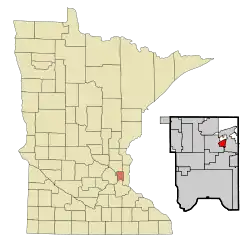 Location of the city of Gem Lake within Ramsey County, Minnesota | |
| Coordinates: 45°3′22″N 93°2′36″W | |
| Country | United States |
| State | Minnesota |
| County | Ramsey |
| Area | |
| • Total | 1.11 sq mi (2.87 km2) |
| • Land | 1.05 sq mi (2.71 km2) |
| • Water | 0.06 sq mi (0.16 km2) |
| Elevation | 958 ft (292 m) |
| Population | |
| • Total | 393 |
| • Estimate (2019)[3] | 500 |
| • Density | 477.10/sq mi (184.17/km2) |
| Time zone | UTC-6 (Central (CST)) |
| • Summer (DST) | UTC-5 (CDT) |
| ZIP code | 55110 |
| Area code(s) | 651 |
| FIPS code | 27-23318[4] |
| GNIS feature ID | 0644064[5] |
| Website | gemlakemn.org |
Geography
According to the United States Census Bureau, the city has a total area of 1.14 square miles (2.95 km2), of which 1.08 square miles (2.80 km2) is land and 0.06 square miles (0.16 km2) is water.[7] Highway 61 serves as a main route. Nearby places include White Bear Lake, Maplewood, Little Canada, and Vadnais Heights.
Demographics
| Historical population | |||
|---|---|---|---|
| Census | Pop. | %± | |
| 1960 | 305 | — | |
| 1970 | 216 | −29.2% | |
| 1980 | 394 | 82.4% | |
| 1990 | 439 | 11.4% | |
| 2000 | 419 | −4.6% | |
| 2010 | 393 | −6.2% | |
| 2019 (est.) | 500 | [3] | 27.2% |
| U.S. Decennial Census[8] | |||
2010 census
As of the census[2] of 2010, there were 393 people, 155 households, and 115 families living in the city. The population density was 363.9 inhabitants per square mile (140.5/km2). There were 161 housing units at an average density of 149.1 per square mile (57.6/km2). The racial makeup of the city was 93.1% White, 5.1% Asian, 1.0% from other races, and 0.8% from two or more races. Hispanic or Latino of any race were 2.5% of the population.
There were 155 households, of which 27.1% had children under the age of 18 living with them, 64.5% were married couples living together, 5.8% had a female householder with no husband present, 3.9% had a male householder with no wife present, and 25.8% were non-families. 20.0% of all households were made up of individuals, and 11.6% had someone living alone who was 65 years of age or older. The average household size was 2.54 and the average family size was 2.94.
The median age in the city was 49.5 years. 19.6% of residents were under the age of 18; 6.1% were between the ages of 18 and 24; 17% were from 25 to 44; 42.5% were from 45 to 64; and 14.8% were 65 years of age or older. The gender makeup of the city was 52.7% male and 47.3% female.
2000 census
As of the census[4] of 2000, there were 419 people, 139 households, and 111 families living in the city. The population density was 378.7 people per square mile (145.7/km2). There were 145 housing units at an average density of 131.0 per square mile (50.4/km2). The racial makeup of the city was 93.79% White, 1.19% African American, 2.63% Asian, 0.72% from other races, and 1.67% from two or more races.
There were 139 households, out of which 44.6% had children under the age of 18 living with them, 66.9% were married couples living together, 8.6% had a female householder with no husband present, and 20.1% were non-families. 18.7% of all households were made up of individuals, and 8.6% had someone living alone who was 65 years of age or older. The average household size was 3.01 and the average family size was 3.40.
In the city, the population was spread out, with 30.3% under the age of 18, 6.9% from 18 to 24, 28.4% from 25 to 44, 23.4% from 45 to 64, and 11.0% who were 65 years of age or older. The median age was 38 years. For every 100 females, there were 98.6 males. For every 100 females age 18 and over, there were 98.6 males.
The median income for a household in the city was $64,167, and the median income for a family was $82,909. Males had a median income of $39,583 versus $28,000 for females. The per capita income for the city was $28,750. About 1.8% of families and 5.9% of the population were below the poverty line, including 4.3% of those under age 18 and none of those age 65 or over.
References
- "2019 U.S. Gazetteer Files". United States Census Bureau. Retrieved July 26, 2020.
- "U.S. Census website". United States Census Bureau. Retrieved 2012-11-13.
- "Population and Housing Unit Estimates". United States Census Bureau. May 24, 2020. Retrieved May 27, 2020.
- "U.S. Census website". United States Census Bureau. Retrieved 2008-01-31.
- "US Board on Geographic Names". United States Geological Survey. 2007-10-25. Retrieved 2008-01-31.
- "2010 Census Redistricting Data (Public Law 94-171) Summary File". American FactFinder. U.S. Census Bureau, 2010 Census. Retrieved 23 April 2011.
- "US Gazetteer files 2010". United States Census Bureau. Archived from the original on January 12, 2012. Retrieved 2012-11-13.
- "Census of Population and Housing". Census.gov. Retrieved June 4, 2015.
External links
Municipalities and communities of Ramsey County, Minnesota, United States | ||
|---|---|---|
| Cities | 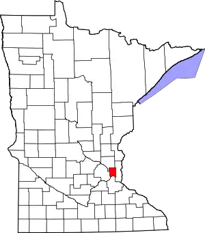 Map of Minnesota highlighting Ramsey County | |
| Township | ||
| Unincorporated communities | ||
| Ghost towns/Neighborhoods | ||
| Footnotes | ‡This populated place also has portions in an adjacent county or counties | |
| ||