List of counties in Minnesota
This is a list of counties in Minnesota. There are 87 counties in the U.S. state of Minnesota. There are also several historical counties.
On October 27, 1849, nine counties were established: Benton, Dahkotah, Itasca, Ramsey, Mahkahta, Pembina, Wabasha, Washington, and Wahnata. Six of these names still exist. With the foundation of Kittson County on March 9, 1878, Pembina County no longer existed.[1] When Minnesota was organized as a state, 57 of the present 87 counties were established. The last county to be created was Lake of the Woods County in 1923.[2]
The names of many of the counties allude to the long history of exploration. Over ten counties are named for Native American groups residing in parts of what is now Minnesota. Another fifteen counties are named after physical geographic features, and the remainder for politicians.
The FIPS county code is the five-digit Federal Information Processing Standard (FIPS) code which uniquely identifies counties and county equivalents in the United States. The three-digit number is unique to each individual county within a state, but to be unique within the entire United States, it must be prefixed by the state code. This means that, for example, the number 001 is shared by Aitkin County, Minnesota, Adams County, Wisconsin, and Adair County, Iowa. To uniquely identify Aitkin County, Minnesota, one must use the state code of 27 plus the county code of 001; therefore, the unique nationwide identifier for Aitkin County, Minnesota is 27001. The links in the column FIPS County Code are to the Census Bureau Info page for that county.[3]
Number of counties listing
| County |
FIPS code[3] | County seat[4] | Est.[1][4] | Origin[5][6][7] | Etymology | Population[4][8] | Area[4][8] | Map |
|---|---|---|---|---|---|---|---|---|
| Aitkin County | 001 | Aitkin | 1857 | Pine County, Ramsey County | William Alexander Aitken (1785-1851), early fur trader with Ojibwe Indians | 16,202 | 1,819.30 sq mi (4,712 km2) | 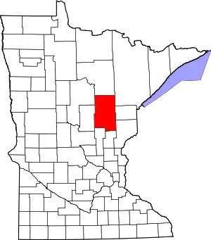 |
| Anoka County | 003 | Anoka | 1857 | Ramsey County | Dakota word meaning "both sides" | 330,844 | 423.61 sq mi (1,097 km2) | 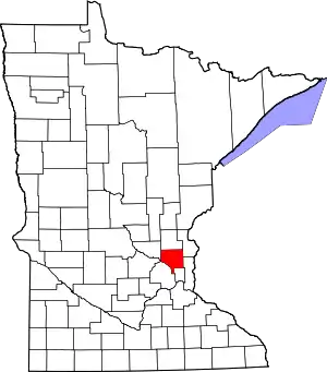 |
| Becker County | 005 | Detroit Lakes | 1858 | Cass County, Pembina County | George Loomis Becker, former state senator and third mayor of Saint Paul (1856–1857) | 32,504 | 1,310.42 sq mi (3,394 km2) | 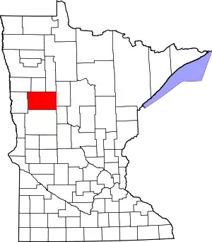 |
| Beltrami County | 007 | Bemidji | 1866 | Unorganized Territory, Itasca County, Pembina County, Polk County | Giacomo Beltrami, Italian explorer who explored the northern reaches of Mississippi River in 1823. | 44,442 | 2,505.27 sq mi (6,489 km2) | 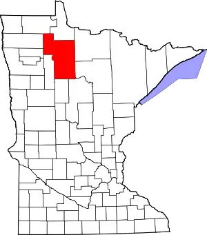 |
| Benton County | 009 | Foley | 1849 | One of nine original counties; formed from residual St. Croix County, Wisconsin Territory. | Thomas Hart Benton (1782–1858), former United States Senator from Missouri (1821-1851) | 38,451 | 408.28 sq mi (1,057 km2) |  |
| Big Stone County | 011 | Ortonville | 1862 | Pierce County | Big Stone Lake, a lake located in the county | 5,269 | 496.95 sq mi (1,287 km2) | 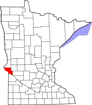 |
| Blue Earth County | 013 | Mankato | 1853 | Unorganized Territory, Dakota County | Blue Earth River, a river that flows through Minnesota | 64,013 | 752.36 sq mi (1,949 km2) |  |
| Brown County | 015 | New Ulm | 1855 | Blue Earth County | Joseph Renshaw Brown (1805-1870), member of Minnesota territorial legislature (1854-55) and prominent pioneer | 25,893 | 610.86 sq mi (1,582 km2) | 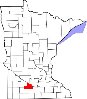 |
| Carlton County | 017 | Carlton | 1857 | Pine County, Saint Louis County | Rueben B. Carlton (1812-1863), early settler and state senator (1857-1858) | 35,386 | 860.33 sq mi (2,228 km2) | 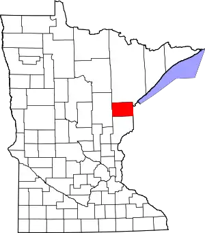 |
| Carver County | 019 | Chaska | 1855 | Hennepin County, Sibley County | Jonathan Carver (1710–1790), early explorer and cartographer of the Mississippi river. | 91,042 | 357.04 sq mi (925 km2) | 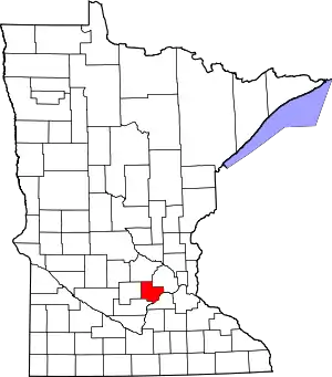 |
| Cass County | 021 | Walker | 1851 | Dakota County, Pembina County, Mankahto County, Wahnata County | Lewis Cass (1782–1866), senator from Michigan (1845–1857) and United States Secretary of State (1831–1836) | 28,567 | 2,017.60 sq mi (5,226 km2) | 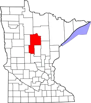 |
| Chippewa County | 023 | Montevideo | 1870 | Pierce County, Davis County | Chippewa River, a river that flows through Minnesota | 12,441 | 582.80 sq mi (1,509 km2) | 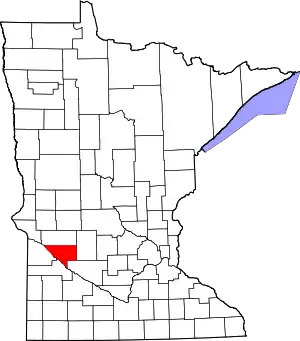 |
| Chisago County | 025 | Center City | 1851 | Washington County, Ramsey County | Chisago Lake, a lake located in the county | 53,887 | 417.63 sq mi (1,082 km2) | 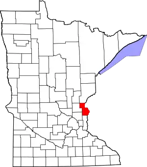 |
| Clay County | 027 | Moorhead | 1862 | Pembina County | Henry Clay (1777-1852), Kentucky statesman and ninth secretary of state of the United States (1825–1829) | 58,999 | 1,045.24 sq mi (2,707 km2) | 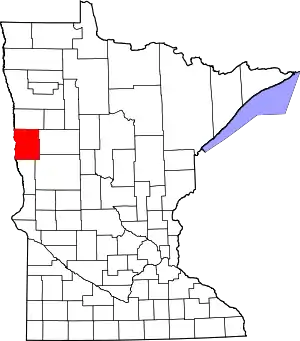 |
| Clearwater County | 029 | Bagley | 1902 | Beltrami County | Clearwater River and lake, both features located in the state | 8,695 | 994.71 sq mi (2,576 km2) | |
| Cook County | 031 | Grand Marais | 1874 | Lake County | Named for Civil War veteran Major Michael Cook of Faribault, who was also a territorial and state senator 1857-62 | 5,176 | 1,450.60 sq mi (3,757 km2) | 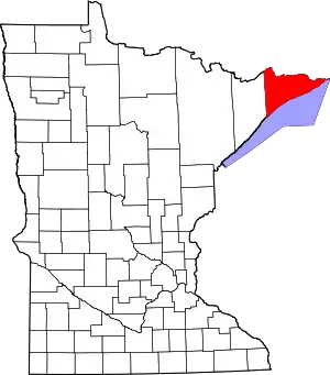 |
| Cottonwood County | 033 | Windom | 1857 | Brown County | Cottonwood River | 11,687 | 639.99 sq mi (1,658 km2) | 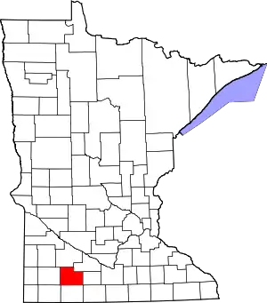 |
| Crow Wing County | 035 | Brainerd | 1857 | Ramsey County | Crow Wing River | 62,500 | 996.57 sq mi (2,581 km2) | 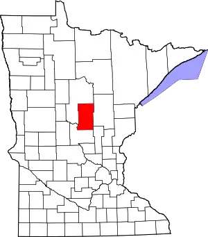 |
| Dakota County | 037 | Hastings | 1849 | One of nine original counties. | From the Dakota language, after a local tribe Dakota, meaning "Allies" | 398,552 | 569.58 sq mi (1,475 km2) | 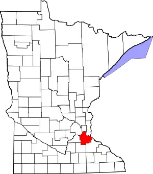 |
| Dodge County | 039 | Mantorville | 1855 | Rice County, Unorganized Territory | Henry Dodge (1782–1867), twice governor of Wisconsin.[9] | 20,087 | 439.50 sq mi (1,138 km2) |  |
| Douglas County | 041 | Alexandria | 1858 | Cass County, Pembina County | Stephen Arnold Douglas (1813-1861), former United States Senator from Illinois (1847-1861) | 36,009 | 634.32 sq mi (1,643 km2) | 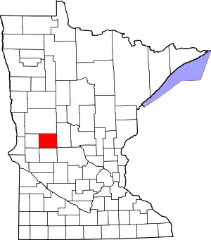 |
| Faribault County | 043 | Blue Earth | 1855 | Blue Earth County | Jean-Baptiste Faribault (1775-1860), early settler and fur trader | 14,553 | 713.63 sq mi (1,848 km2) | 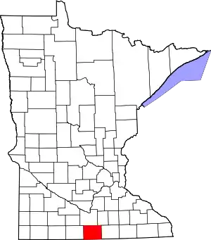 |
| Fillmore County | 045 | Preston | 1853 | Wabasha County | Millard Fillmore (1800-1874), thirteenth president of the United States (1850-1853) | 20,866 | 861.25 sq mi (2,231 km2) | 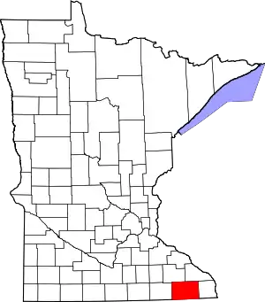 |
| Freeborn County | 047 | Albert Lea | 1855 | Blue Earth County, Rice County | William S. Freeborn (1816-1900), member of the Territorial Legislature | 31,255 | 707.64 sq mi (1,833 km2) | 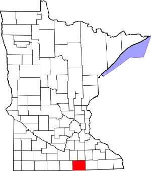 |
| Goodhue County | 049 | Red Wing | 1853 | Wabasha County, Dakota County | James Madison Goodhue, the first newspaper editor in Minnesota.[10] | 46,183 | 758.27 sq mi (1,964 km2) | 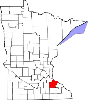 |
| Grant County | 051 | Elbow Lake | 1868 | Stevens County, Wilkin County, Traverse County | Ulysses S. Grant (1822-1885), eighteenth president of the United States (1869-1877) | 6,018 | 546.41 sq mi (1,415 km2) | 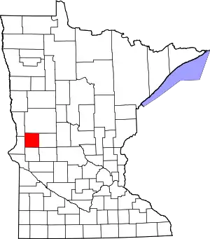 |
| Hennepin County | 053 | Minneapolis | 1852 | Dakota County | Father Louis Hennepin (1626-1705), early explorer of the Twin Cities area in the 17th Century | 1,152,425 | 556.62 sq mi (1,442 km2) | 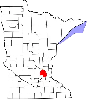 |
| Houston County | 055 | Caledonia | 1854 | Fillmore County | Sam Houston (1793–1863), the second and fourth president of the Republic of Texas and seventh governor of Texas | 19,027 | 558.41 sq mi (1,446 km2) |  |
| Hubbard County | 057 | Park Rapids | 1883 | Cass County | Lucius Frederick Hubbard (1836-1913), ninth governor of Minnesota (1882-1887) | 20,428 | 922.46 sq mi (2,389 km2) | 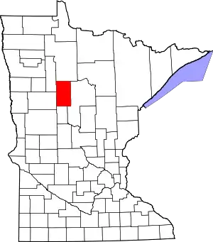 |
| Isanti County | 059 | Cambridge | 1857 | Ramsey County | Division of the Dakotas called the Izatys, meaning [those that] dwell at Knife Lake, after where they resided. | 37,816 | 439.07 sq mi (1,137 km2) | 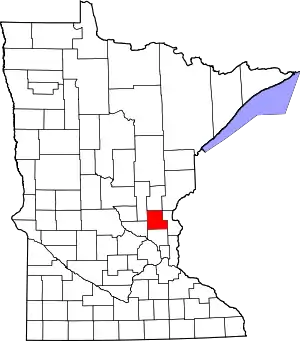 |
| Itasca County | 061 | Grand Rapids | 1849 | One of nine original counties; formed from residual La Pointe County, Wisconsin Territory. | Lake Itasca, source of the Mississippi River (located in northwestern Minnesota). | 45,058 | 2,665.06 sq mi (6,902 km2) | 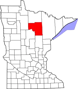 |
| Jackson County | 063 | Jackson | 1857 | Brown County | Henry Jackson, member of the first territorial legislature and the first merchant in St. Paul | 10,266 | 701.69 sq mi (1,817 km2) | 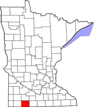 |
| Kanabec County | 065 | Mora | 1858 | Pine County | From the Ojibwe language Kan-a-bec-o-si-pi (Ginebigo-ziibi), meaning Snake River, which flows through the county | 16,239 | 524.93 sq mi (1,360 km2) | 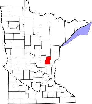 |
| Kandiyohi County | 067 | Willmar | 1858 | Meeker County, Renville County, Pierce County, Davis County, Stearns County | From the Sioux language for "buffalo fish" | 42,239 | 796.06 sq mi (2,062 km2) | 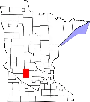 |
| Kittson County | 069 | Hallock | 1879 | Pembina County | Norman Kittson (1814-1888), businessman and mayor of Saint Paul (1858-1859) | 4,552 | 1,097.08 sq mi (2,841 km2) | 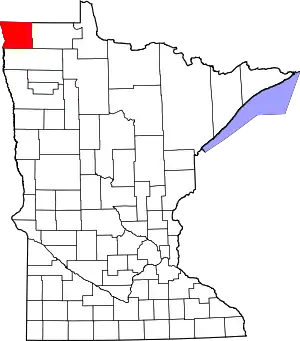 |
| Koochiching County | 071 | International Falls | 1906 | Itasca County | From the Ojibwe language Gojijiing (Place of inlets), which was the Cree name for Rainy Lake and Rainy River. | 13,311 | 3,102.36 sq mi (8,035 km2) | 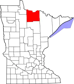 |
| Lac qui Parle County | 073 | Madison | 1871 | Redwood County | French phrase meaning "lake which talks". | 7,259 | 764.87 sq mi (1,981 km2) | 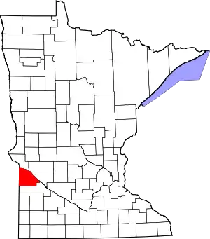 |
| Lake County | 075 | Two Harbors | 1856 | Itasca County | Lake Superior, which forms one of its edges | 10,866 | 2,099.16 sq mi (5,437 km2) | 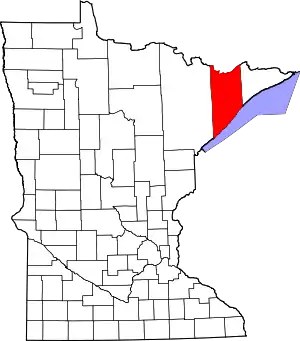 |
| Lake of the Woods County | 077 | Baudette | 1923 | Beltrami County | Lake of the Woods, a lake located within the county. | 4,045 | 1,296.70 sq mi (3,358 km2) | 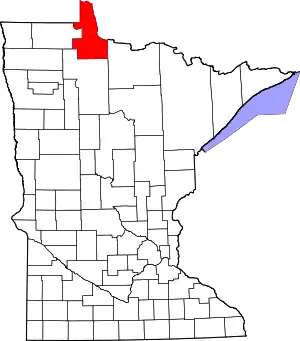 |
| Le Sueur County | 079 | Le Center | 1853 | Dakota County | Pierre-Charles Le Sueur (1657-1704), fur trader and early explorer of the Minnesota River Valley | 27,703 | 448.50 sq mi (1,162 km2) | 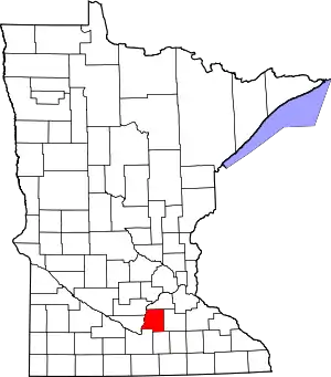 |
| Lincoln County | 081 | Ivanhoe | 1873 | Lyon County | Abraham Lincoln (1809-1865), sixteenth president of the United States (1861-1865) | 5,896 | 537.03 sq mi (1,391 km2) |  |
| Lyon County | 083 | Marshall | 1871 | Redwood County | Nathaniel Lyon (1818–1861), United States Army general killed during the Civil War | 25,857 | 714.17 sq mi (1,850 km2) | 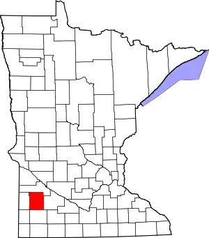 |
| McLeod County | 085 | Glencoe | 1856 | Carver County, Sibley County | Martin McLeod early pioneer and member of the territorial legislature (1849–1856) | 36,651 | 491.91 sq mi (1,274 km2) | 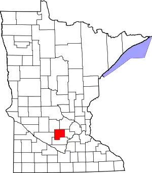 |
| Mahnomen County | 087 | Mahnomen | 1906 | Norman County | Ojibwa word meaning "wild rice". | 5,413 | 556.14 sq mi (1,440 km2) | 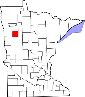 |
| Marshall County | 089 | Warren | 1879 | Kittson County | William Rainey Marshall (1825-1896), fifth governor of Minnesota (1866-1870) | 9,439 | 1,772.24 sq mi (4,590 km2) | 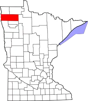 |
| Martin County | 091 | Fairmont | 1857 | Faribault County, Brown County | Morgan Lewis Martin (1805-1887), delegate to Congress from Wisconsin Territory | 20,840 | 709.34 sq mi (1,837 km2) | 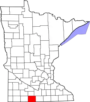 |
| Meeker County | 093 | Litchfield | 1856 | Davis County | Bradley B. Meeker (1813–1873), Associate Justice of the Minnesota Territorial Supreme Court (1849–1853) | 23,300 | 608.54 sq mi (1,576 km2) | 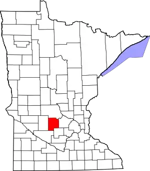 |
| Mille Lacs County | 095 | Milaca | 1857 | Ramsey County | Mille Lacs Lake, a lake located within the county. | 26,097 | 574.47 sq mi (1,488 km2) | 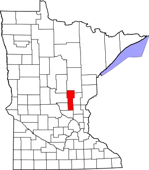 |
| Morrison County | 097 | Little Falls | 1856 | Benton County | William & Allan Morrison, fur trading brothers[11] | 33,198 | 1,124.50 sq mi (2,912 km2) | 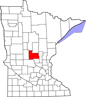 |
| Mower County | 099 | Austin | 1855 | Rice County | John Edward Mower (1815–1879), member of the Minnesota territorial legislature in the 1850s | 39,163 | 711.50 sq mi (1,843 km2) | 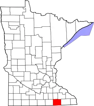 |
| Murray County | 101 | Slayton | 1857 | Brown County | William Pitt Murray (1825–1910), Minnesota statesman and member of the territorial legislature (1852–1855) and 1857 | 8,725 | 704.43 sq mi (1,824 km2) | 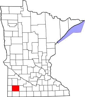 |
| Nicollet County | 103 | St. Peter | 1853 | Dakota County | Joseph Nicolas Nicollet (1786–1843), early explorer and cartographer of the Upper Mississippi River | 32,727 | 452.29 sq mi (1,171 km2) | 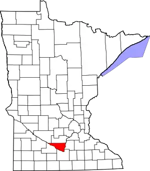 |
| Nobles County | 105 | Worthington | 1857 | Brown County | William H. Nobles, member of the Minnesota territorial legislature in 1854 and 1856 | 21,378 | 715.39 sq mi (1,853 km2) | 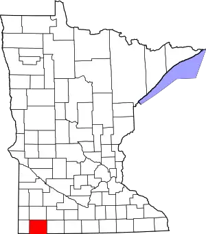 |
| Norman County | 107 | Ada | 1881 | Polk County | Early Norwegian, also known as Norman, settlers. | 6,852 | 876.27 sq mi (2,270 km2) | 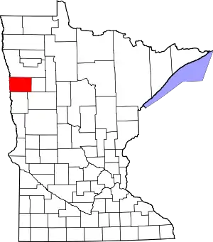 |
| Olmsted County | 109 | Rochester | 1855 | Fillmore County, Wabasha County, Rice County | David Olmsted, first mayor of Saint Paul and member of territorial legislature (1849-1850) | 144,248 | 653.01 sq mi (1,691 km2) | 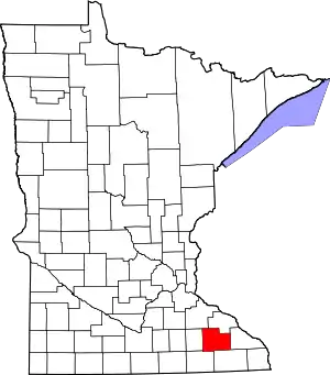 |
| Otter Tail County | 111 | Fergus Falls | 1858 | Pembina County, Cass County | Otter Tail Lake, a lake located within the county | 57,303 | 1,979.71 sq mi (5,127 km2) | 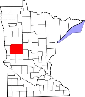 |
| Pennington County | 113 | Thief River Falls | 1910 | Red Lake County | Edmund Pennington (b. 1848), executive of the Minneapolis, St. Paul and Sault Ste. Marie Railroad | 13,930 | 616.54 sq mi (1,597 km2) | 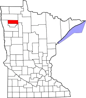 |
| Pine County | 115 | Pine City | 1856 | Chisago County, Ramsey County | Giant forests of Eastern White Pine and Red Pine that flourish in the county | 29,750 | 1,411.04 sq mi (3,655 km2) | 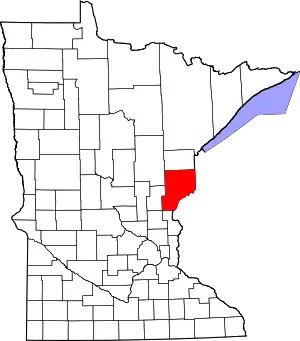 |
| Pipestone County | 117 | Pipestone | 1857 | Brown County | Name of a sacred Dakota quarry of red pipestone found in the county | 9,596 | 465.89 sq mi (1,207 km2) | 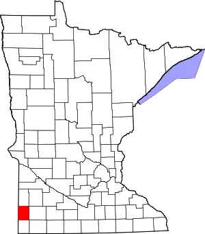 |
| Polk County | 119 | Crookston | 1858 | Pembina County | James K. Polk (1795-1849), eleventh president of the United States (1845-1849) | 31,600 | 1,970.37 sq mi (5,103 km2) | 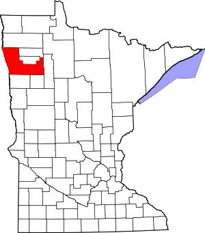 |
| Pope County | 121 | Glenwood | 1862 | Pierce County, Cass County, Unorganized Territory | John Pope (1822–1892), United States Army general during the Dakota War of 1862 | 10,995 | 670.14 sq mi (1,736 km2) | 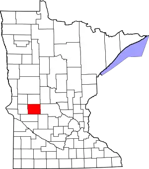 |
| Ramsey County | 123 | Saint Paul | 1849 | One of nine original counties; formed from residual St. Croix County, Wisconsin Territory. | Alexander Ramsey (1815-1903), second governor of Minnesota (1860-1863) | 508,640 | 155.78 sq mi (403 km2) | 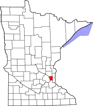 |
| Red Lake County | 125 | Red Lake Falls | 1896 | Polk County | Red Lake River, a river that flows through Minnesota. | 4,089 | 432.43 sq mi (1,120 km2) | 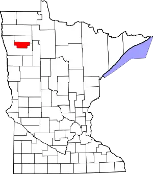 |
| Redwood County | 127 | Redwood Falls | 1862 | Brown County | Redwood River, a river that flows through Minnesota. | 16,059 | 879.73 sq mi (2,278 km2) | 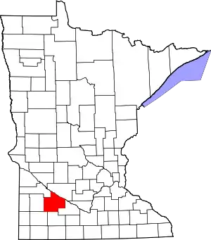 |
| Renville County | 129 | Olivia | 1855 | Nicollet County, Pierce County, Sibley County | Joseph Renville (1779-1846), interpreter for early explorations of the Louisiana Purchase | 15,730 | 982.92 sq mi (2,546 km2) | 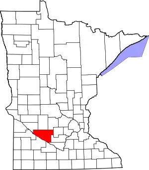 |
| Rice County | 131 | Faribault | 1853 | Dakota County, Wabasha County | Henry Mower Rice (1816-1894), former United States Senator from Minnesota (1858-1863) | 64,142 | 497.57 sq mi (1,289 km2) | 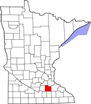 |
| Rock County | 133 | Luverne | 1857 | Brown County | Large rocky plateau located within the county, known as "the mound." | 9,687 | 482.61 sq mi (1,250 km2) |  |
| Roseau County | 135 | Roseau | 1894 | Kittson County, Beltrami County | Roseau River and Roseau Lake, both of which are located nearby | 15,629 | 1,662.51 sq mi (4,306 km2) | 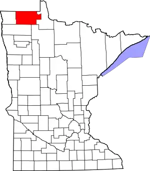 |
| Saint Louis County | 137 | Duluth | 1855 | Itasca County, Newton | Saint Louis River, a river that flows through Minnesota | 200,226 | 6,225.16 sq mi (16,123 km2) | 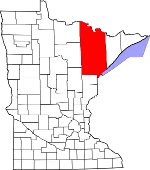 |
| Scott County | 139 | Shakopee | 1853 | Dakota County | Winfield Scott (1786–1866), United States Army general who served from (1808–1861) | 129,928 | 356.68 sq mi (924 km2) | 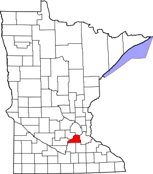 |
| Sherburne County | 141 | Elk River | 1856 | Benton County | Moses Sherburne (1813–1873), Associate Justice of the Minnesota Territorial Supreme Court (1853-1857) | 88,499 | 436.30 sq mi (1,130 km2) | 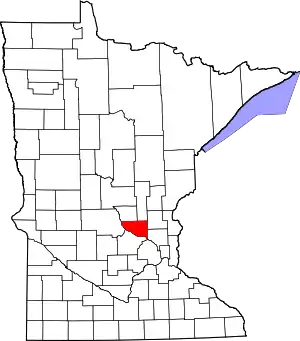 |
| Sibley County | 143 | Gaylord | 1853 | Dakota County | Henry Hastings Sibley (1811-1891), first governor of Minnesota (1858-1860) | 15,226 | 588.65 sq mi (1,525 km2) | 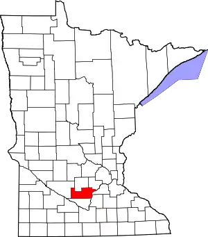 |
| Stearns County | 145 | St. Cloud | 1855 | Cass County, Nicollet County, Pierce County, Sibley County | Charles Thomas Stearns (1814-1888), early settler of St. Cloud and member of the Minnesota territorial legislature (1849-1858) | 150,642 | 1,344.52 sq mi (3,482 km2) | 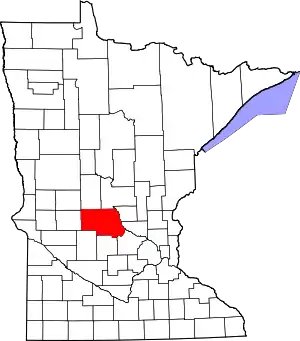 |
| Steele County | 147 | Owatonna | 1855 | Rice County, Blue Earth County, Le Sueur County | Franklin Steele (1813-1880), early settler of Minneapolis and developer of Saint Anthony Falls | 36,576 | 429.55 sq mi (1,113 km2) | 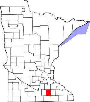 |
| Stevens County | 149 | Morris | 1862 | Pierce County, Unorganized Territory | Isaac Ingalls Stevens (1818-1862), first governor of Washington Territory (1853-1857) | 9,726 | 562.06 sq mi (1,456 km2) | 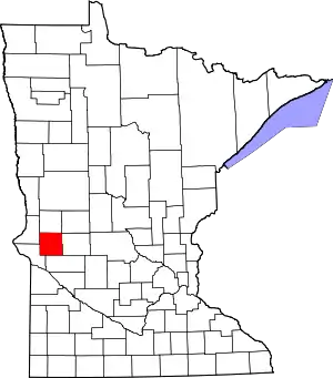 |
| Swift County | 151 | Benson | 1870 | Chippewa County | Henry Adoniram Swift (1823-1869), third governor of Minnesota (1863-1864) | 9,783 | 743.53 sq mi (1,926 km2) |  |
| Todd County | 153 | Long Prairie | 1855 | Cass County | John Blair Smith Todd, commander of Fort Ripley (1849-56); general in the Civil War; delegate in Congress from Dakota Territory (1861 and 1863-65); governor of Dakota Territory (1869-71) | 24,895 | 942.02 sq mi (2,440 km2) | 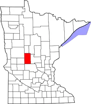 |
| Traverse County | 155 | Wheaton | 1862 | Pierce County, Unorganized Territory | Lake Traverse, a lake located in the county. | 3,558 | 574.09 sq mi (1,487 km2) | 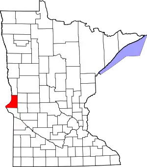 |
| Wabasha County | 157 | Wabasha | 1849 | One of nine original counties. | Named after M'dewakanton Dakota Indian Chief Wabasha III | 21,676 | 525.01 sq mi (1,360 km2) | 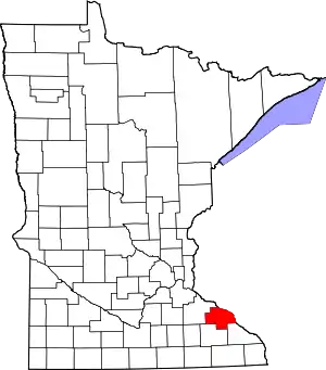 |
| Wadena County | 159 | Wadena | 1858 | Cass County, Todd County | Wadena Trading Post, in turn for a Ojibway word meaning "a little round hill". | 13,843 | 535.02 sq mi (1,386 km2) | 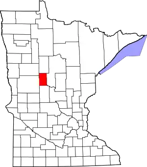 |
| Waseca County | 161 | Waseca | 1857 | Steele County | Dakota word meaning "rich and fertile" | 19,136 | 423.25 sq mi (1,096 km2) | 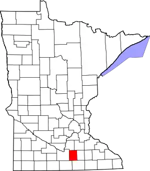 |
| Washington County | 163 | Stillwater | 1849 | One of nine original counties; formed from residual St. Croix County, Wisconsin Territory. | George Washington (1732-1799), first president of the United States (1789-1797) | 238,136 | 391.70 sq mi (1,014 km2) | 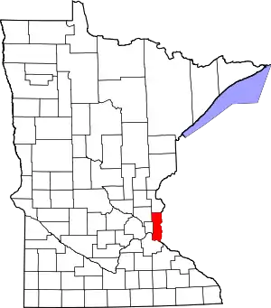 |
| Watonwan County | 165 | St. James | 1860 | Brown County | Watonwan River, a river that flows through Minnesota. | 11,211 | 434.51 sq mi (1,125 km2) |  |
| Wilkin County | 167 | Breckenridge | 1858 | Cass County, Pembina County | Alexander Wilkin (1820-1864), Minnesota politician and soldier killed in the Civil War | 6,576 | 751.43 sq mi (1,946 km2) | 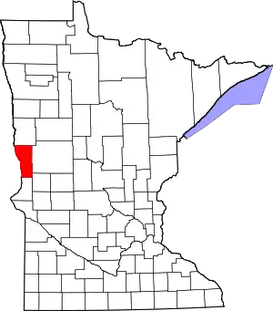 |
| Winona County | 169 | Winona | 1854 | Fillmore County, Wabasha County | Named after Wee-No-Nah, Sister or Cousin of Chief Wabasha III | 51,461 | 626.30 sq mi (1,622 km2) | 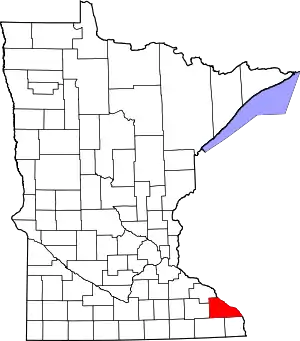 |
| Wright County | 171 | Buffalo | 1855 | Cass County, Sibley County | Silas Wright (1795-1847), former United States Senator from New York (1833-1844) | 124,700 | 660.75 sq mi (1,711 km2) | 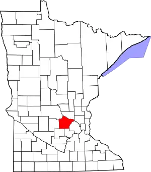 |
| Yellow Medicine County | 173 | Granite Falls | 1871 | Redwood County | Yellow Medicine River, a river that flows through Minnesota. | 10,438 | 757.96 sq mi (1,963 km2) | 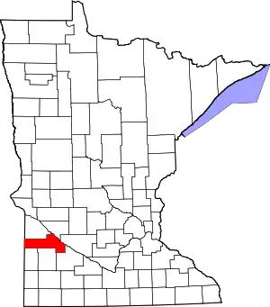 |
Historical counties
- St. Clair County, Indiana (1801–12) (Transferred to Illinois in 1809)
- St. Charles County, Louisiana (1809–13) (Transferred to Missouri in 1812)
- Madison County (IL) (1812–18) Formed from St. Clair County (IL)
- Michilimackinac County, Michigan Territory (1818–37)
- Crawford County, Michigan and Wisconsin Territories (1818–40)
- Chippewa County, Michigan Territory (1827–37)
- Dubuque County (MI) (1834–37)
- Fayette County (WI) (1837–49)
- St. Croix County, Wisconsin Territory (1840–49)
- La Pointe County, Wisconsin Territory (1845–49) Formed from St. Croix
- Mahkatah County (1849–51) (Mahkahto) (One of Original 9 counties) Dissolved to Pembina and Cass
- Wahnata County (1849–51) (One of Original 9 counties) Dissolved to Pembina and Cass
- Buchanan County (1857–61) Formed from Pine County, Dissolved back to Pine
- Pierce County (1853–62) Formed from Dakota County
- Superior County Name change to Saint Louis County then to Lake.
- Davis County (1855–62) Formed from Cass, Nicollet and Sibley Counties
- Toombs County (1858–62) Formed from Pembina. Name Changed to Andy Johnson.
- Newton County (1855–6) Formed from Itasca County and Un-Organized. Name Changed from Doty County, then to Saint Louis County.
- Monroe County merged with Mille Lacs.
- Lincoln County (1861–8) Formed from Renville County
- Lac qui Parle County (1862–8) Formed from Davis
- Manomin County (1857–1869) Formed from Ramsey County, Merged into Anoka County.
- Monongalia County (1861–70)Formed from Ramsey County, Pierce County and un-Organized. Dissolved to Kandiyohi County.
- Aiken County (1857–72) Formed from Pine and Ramsey Counties, Change name to Aitkin County
- Pembina County (1849–78) (One of Original 9 counties) Name Change to Kittson County
- Saint Louis County. Name change from Superior, then to Lake.
- Breckenridge County (1858–62) Formed from Pembina. Name Change to Clay in 1862
- Andy Johnson County (1862–8) Formally Toombs county. Named changed to Wilkin.
- Midway County (1857–8) Area created from Brown county, overlapped Pipestone county. Dissolved in 1858 when the State of Minnesota was formed and the rest of the territory not added to the state became unorganized.
See also
- List of Minnesota county name etymologies
- List of Minnesota county seats
References
- "Minnesota Place Names". Minnesota Historical Society. Archived from the original on 2007-08-14. Retrieved 2007-09-17.
- "Minnesota County History". Association of Minnesota Counties. Archived from the original on 2007-08-13. Retrieved 2007-09-02.
- "EPA County FIPS Code Listing". EPA. Retrieved 2007-04-09.
- National Association of Counties. "NACo - Find a county". Archived from the original on 30 September 2007. Retrieved 24 February 2012.
- Upham, Warren (1969). Minnesota Geographic Names. St. Paul: Minnesota Historical Society.
- "County Name Origins". Association of Minnesota Counties. Archived from the original on 2008-05-27. Retrieved 2008-11-05.
- "Origin of Minnesota County Name". Minnesota Secretary of State. Archived from the original on 2008-11-08. Retrieved 2008-11-05.
- "Minnesota QuickFacts". U.S. Census Bureau. Archived from the original on 17 January 2016. Retrieved 24 February 2012. (2010 Census)
- "Dodge County History" (PDF). Dodge County website. Archived from the original (PDF) on 2008-04-11. Retrieved 2008-02-17.
- "The History of Goodhue County". Goodhue County, Minnesota website. Archived from the original on 2008-06-06. Retrieved 2008-02-17.
- MCHS - William Morrison - Fur Trader Archived 2008-07-23 at the Wayback Machine
