Geographic Center of Taiwan
Geographic Center of Taiwan is the center point of Taiwan Island. It is located at Mount Hutou (t 虎頭山, s 虎头山, Hutoushan, "Tiger Head Mountain") in the township of Puli in Nantou County, Taiwan.[1]
| 臺灣地理中心 | |
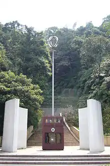 The first Geographic Center of Taiwan Monument | |
| Location | Mount Hutou Puli Nantou County Taiwan |
|---|---|
| Geographic Center of Taiwan | |||||||||
|---|---|---|---|---|---|---|---|---|---|
| Traditional Chinese | 臺灣地理中心 | ||||||||
| |||||||||
History
The first Geographic Center of Taiwan monument was constructed at the base of Mount Hutou in the 1970s. Following improved surveying, another monument was built later on, on the peak of the mountain. The peak monument was built on the former site of the Yoshitaka Shrine erected by the Japanese during their occupation of Taiwan.
Architecture
The base monument features an inscription by former President Chiang Ching-kuo. There are concentric steel rings on top of the monument pole, forming the basis of Puli Township logo.
The peak monument was built in an aboriginal style, using columns with flare tops.
See also
- Geography of Taiwan
- Cape Fugui, the northernmost point on Taiwan
- Eluanbi, the southernmost point on Taiwan
References
- "The Geographic Center of Taiwan 台灣地理中心". Spectral Codex. Oct 30, 2015.
| Wikimedia Commons has media related to Taiwan Geographical Center Stele. |