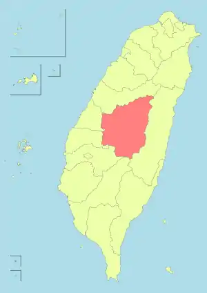
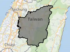
Nantou County
Nantou County (Chinese: 南投縣; pinyin: Nántóu Xiàn; Hokkien POJ: Lâm-tâu-koān; Hakka PFS: Nàm-thèu-yen) is the second largest county of Taiwan, located in the central part of the country.[1] It is also the only landlocked county in Taiwan. Its name derives from the Hoanya Taiwanese aboriginal word Ramtau.[2]
Nantou County
南投縣 | |||||||||||
|---|---|---|---|---|---|---|---|---|---|---|---|
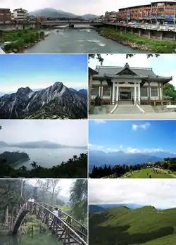 Top:Shuili Water Creek in Shuili Township, 2nd left:Mount Yu, 2nd right:Nantou County Museum of History in Nantou City, 3rd left:View of Sun Moon Lake, from Xuanzang Temple in Yuchi Township, 3rd right:Evergreen Glassland in Renci Township, Bottom left:Tou George Pond in Taiwan Educational University of Nature, Bottom right:Mount Hehuan | |||||||||||
 Flag  Logo | |||||||||||
 | |||||||||||
| |||||||||||
| Coordinates: 23°54′55.28″N 120°41′4.32″E | |||||||||||
| Country | |||||||||||
| Province | Taiwan | ||||||||||
| Seat | Nantou City | ||||||||||
| Largest city | Nantou City | ||||||||||
| Boroughs | 1 city, 12 (4 urban, 8 rural) townships | ||||||||||
| Government | |||||||||||
| • County Magistrate | Lin Ming-chen (KMT) | ||||||||||
| Area | |||||||||||
| • Total | 4,106.436 km2 (1,585.504 sq mi) | ||||||||||
| Area rank | 2 of 22 | ||||||||||
| Population (Dec. 2014) | |||||||||||
| • Total | 514,315 | ||||||||||
| • Rank | 15 of 22 | ||||||||||
| • Density | 130/km2 (320/sq mi) | ||||||||||
| Time zone | UTC+8 (National Standard Time) | ||||||||||
| ISO 3166 code | TW-NAN | ||||||||||
| Website | www.nantou.gov.tw | ||||||||||
| |||||||||||
| Nantou County | |||||||||||||||||||||||||||||
|---|---|---|---|---|---|---|---|---|---|---|---|---|---|---|---|---|---|---|---|---|---|---|---|---|---|---|---|---|---|
| Traditional Chinese | 南投縣 | ||||||||||||||||||||||||||||
| |||||||||||||||||||||||||||||
Its mountainous area makes it a tourist destination; Sun Moon Lake is located in this county. Other well-known areas of the county are Hehuanshan and Sitou. Notable cities in Nantou are Nantou City and Puli Town. The official butterfly of Nantou County is the broad-tailed swallowtail butterfly (Agehana maraho). Nantou's tung-ting tea is one of the most famous and high-quality oolong teas grown in Taiwan.[3]
History
Early history
Before the arrival of Han Chinese to Nantou, the Atayal, Bunun and Tsou tribes were distributed throughout the northern and central Nantou. These groups pioneered the early development of mountain regions in Nantou.[4]
Kingdom of Tungning
In 1677, Lin Yi (Chinese: 林圯), a general under the command of Koxinga, led soldiers to establish residence in Shalianbao (modern-day Zhushan). The Han Chinese began to enter Nantou via two main routes, the Zhuoshui River and Maoluo River.[4]
Japanese rule
In 1901, during Japanese rule, Nanto Chō (Japanese: 南投廳) was one of twenty local administrative offices established. In 1909, part of Toroku Chō (斗六廳) was merged into Nanto Cho. A major reorganization occurred in 1920, in which the area was administered under Taichū Prefecture together with modern-day Changhua County and Taichung City.
Republic of China
After the handover of Taiwan from Japan to the Republic of China on 25 October 1945, the present day area of Nantou County was administered under Taichung County of Taiwan Province.[5] On 16 August 1950, Nantou County was established by its separation from Taichung County, and Nantou Township was designed as the county seat. On 1 July 1957, the Zhongxing New Village in Nantou Township was designed to be the capital of Taiwan Province from the former Taipei City. In 1981, the county seat was upgraded from Nantou Township to Nantou City. The Chi-Chi earthquake occurred in 1999.
Geography

Nantou County has an area of 4,106.436 km2 (1,585.504 sq mi) with a width of 72 km (45 mi) and length of 95 km (59 mi). It is the second largest county in Taiwan after Hualien County.[6]
There are 41 mountains with peaks over 3,000 meters high, with Mount Yu in Xinyi Township is the highest peak in Nantou County and in Taiwan with a height of 3,952 meters. Around 83% of Nantou County area is covered by hills and mountains.
Rain that falls into the mountains area converge into the Dadu River and Zhuoshui River. There are inland ponds and lakes throughout the mountains in the county, such as the Sun Moon Lake, Bi Pond, Liyu Pond and Cilin Pond.
Climate
The annual average temperature in Nantou County is 23 °C (73 °F) on level ground and 20 °C (68 °F) on mountains. The annual average rainfall is less than 1,750 mm (68.9 in) on level ground and 2,800 mm (110.2 in) on mountains. The rainy season lasts from April to September and the dry season lasts from October to March.[6]
Government
.jpg.webp)

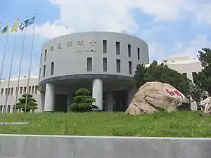
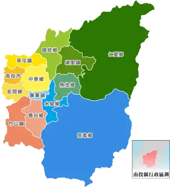
Nantou County consists of 1 city, 4 urban townships, 6 rural townships, 2 mountain indigenous townships, 128 villages and 133 neighborhoods.[7][8][9] Nantou City is the seat of the county which houses the Nantou County Government and Nantou County Council. The incumbent Magistrate of Nantou County is Lin Ming-chen of the Kuomintang.
Administrative divisions
| Type | Name | Chinese | Taiwanese | Hakka | Formosan |
|---|---|---|---|---|---|
| City | Nantou City | 南投市 | Lâm-tâu | Nàm-thèu | |
| Urban townships |
Caotun | 草屯鎮 | Chháu-tūn | Chhó-thùn | |
| Jiji | 集集鎮 | Chi̍p-chi̍p | Si̍p-si̍p | ||
| Puli | 埔里鎮 | Po͘-lí | Phû-lî | ||
| Jhushan (Zhushan) | 竹山鎮 | Tek-san | Tsuk-sân | ||
| Rural townships |
Guosing (Guoxing) | 國姓鄉 | Kok-sèng | Koet-siang | |
| Lugu | 鹿谷鄉 | Lo̍k-kok | Lu̍k-kuk | ||
| Mingjian | 名間鄉 | Bêng-kan | Miàng-kiên | ||
| Shueili (Shuili) | 水里鄉 | Chúi-lí | Súi-lî | ||
| Yuchih (Yuchi) | 魚池鄉 | Hî-tî | Ǹg-tshṳ̀ | QabizayThao | |
| Jhongliao (Zhongliao) | 中寮鄉 | Tiong-liâu | Chûng-liàu | ||
| Mountain indigenous townships |
Ren-ai (Ren'ai) | 仁愛鄉 | Jîn-ài | Yìn-oi | Atayal, Bunun, Seediq |
| Sinyi (Xinyi) | 信義鄉 | Sìn-gī | Sin-ngi | Nehunpu-siangBunun |
Colors indicate statutory language status of Hakka and Formosan languages in the respective subdivisions.
Politics
南投縣 Nantou County voted two Kuomintang legislators out of two seats to be in the Legislative Yuan during the 2016 Republic of China legislative election.[10]
Demographics and culture
| Year | Pop. | ±% |
|---|---|---|
| 1985 | 535,572 | — |
| 1990 | 536,479 | +0.2% |
| 1995 | 546,517 | +1.9% |
| 2000 | 541,537 | −0.9% |
| 2005 | 535,205 | −1.2% |
| 2010 | 526,491 | −1.6% |
| 2015 | 509,490 | −3.2% |
| Source:"Populations by city and country in Taiwan". Ministry of the Interior Population Census. | ||
Population
Nantou County has a population of 492,733 people as of January 2020.
- The following information is as of June 2020資料
| City Name | acreage (km²) | 下轄村 -{里}-數 | 下轄 鄰數 | Population | 人口 消長 | The population density (人/km²) | Postcode | Geographical division |
|---|---|---|---|---|---|---|---|---|
| Nantou City南投市 | 71.6021 | 34 | 814 | 99,263 | -21 | 1,386 | 540 | 烏溪 |
| Puli埔里鎮 | 162.2227 | 33 | 569 | 79,556 | -51 | 490 | 545 | 烏溪 |
| Caotun草屯鎮 | 104.0327 | 27 | 608 | 97,659 | +35 | 939 | 542 | 烏溪 |
| Jhushan (Zhushan)竹山鎮 | 247.3339 | 28 | 482 | 53,684 | -49 | 217 | 557 | 濁水溪 |
| Jiji集集鎮 | 49.7268 | 11 | 127 | 10,554 | -4 | 212 | 552 | 濁水溪 |
| Mingjian名間鄉 | 83.0955 | 23 | 372 | 37,728 | -19 | 454 | 551 | 濁水溪 |
| Lugu鹿谷鄉 | 141.8981 | 13 | 174 | 17,329 | -10 | 122 | 558 | 濁水溪 |
| Jhongliao (Zhongliao)中寮鄉 | 146.6541 | 18 | 258 | 14,460 | +25 | 98 | 541 | 烏溪 |
| Yuchih (Yuchi)魚池鄉 | 121.3735 | 13 | 192 | 15,544 | -9 | 128 | 555 | 烏溪 |
| Guosing (Guoxing)國姓鄉 | 175.7042 | 13 | 159 | 18,056 | -11 | 103 | 544 | 烏溪 |
| 水-{里}-鄉 | 106.8424 | 19 | 210 | 17,177 | -29 | 161 | 553 | 濁水溪 |
| Sinyi (Xinyi)信義鄉 | 1,422.4188 | 14 | 119 | 15,899 | +6 | 11 | 556 | 濁水溪 |
| Ren-ai (Ren'ai)仁愛鄉 | 1,273.5312 | 16 | 195 | 15,824 | -7 | 12 | 546 | 烏溪 |
| Nantou County南投縣 | 4,106.4360 | 262 | 4,279 | 492,733 | -144 | 120 |
- The population growth and decline is calculated by subtracting the population of the previous month from the current month’s population. Negative values are represented by red letters, positive values are represented by blue letters, and no growth is represented by green letters.
- The population density of each district is calculated by rounding 4 to 5 to 1 decimal place
- Population growth:
- 高度成長 High growth (年成長率高於1%) :NA(updated 2020)
- 穩定成長 Steady growth (年成長率0.1%~1%) :草屯 Caotun
- 成長停滯 Stagnant growth(年成長率±0.1%) :NA(updated 2020)
- 輕度流失 Mild loss (年成長率-0.5%~-0.1%):南投、仁愛
- 中度流失 Moderate Churn (年成長率-1%~-0.5%) :埔里Puli、名間、魚池
- 高度流失 High churn (年成長率-2%~-1%) :鹿谷、竹山、中寮、信義、水-{里}-、集集
- 嚴重流失 Severe drain (年成長率低於-2%) :國姓
Language
The official language of the county is Mandarin. Taiwanese, Hakka, English and aboriginal languages are also spoken.[11]
Education
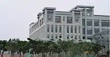
There are 2 colleges, 13 senior high and vocational schools, 30 junior high schools, 149 elementary schools, 106 kindergartens and 84 day care centers in the county.[12] Notable universities in the county are National Chi Nan University and Nan Kai University of Technology.
Energy

Nantou County houses Taiwan's first pumped-storage hydroelectric power plant, the Takuan Pumped Storage Hydro Power Plant commissioned in 1985 with an installed capacity of 1,008 MW. It also houses Taiwan's largest pumped-storage hydroelectric power plant, the Mingtan Pumped Storage Hydro Power Plant with an installed capacity of 1,602 MW. Both power plants are located in Shuili Township along the Shuili River.
Tourist attractions
- Chung Tai Chan Monastery
- Ci En Pagoda
- Paper Dome
- Fonghuanggu Bird and Ecology Park
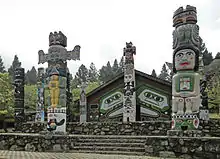
- Formosan Aboriginal Culture Village
- Jufang Hall
- Lalu Island
- Ming Shan Resort
- Nantou County Culture Park
- Qingjing Farm
- Shanlinxi Forest Recreation Area
- Sun Moon Lake
- Sun Moon Lake Wen Wu Temple
- Taroko National Park
- Wushe Incident Memorial Park
- Xitou Nature Education Area
- Xuanzang Temple
- Yushan National Park
- Zhushan Zinan Temple
Transportation
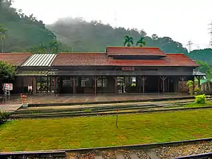
Rail
Nantou County is served by the Jiji Line of Taiwan Railways which consists of Checheng, Jiji, Longquan, Shuili and Zhuoshui Station
References
- See List of administrative divisions of Taiwan
- 南投的地方起源與變遷 (in Chinese). Archived from the original on 2012-02-06.
此地原本為平埔族Arikun族南投(Ramtau)社之故址所在,此「南投」之地名即翻譯自平埔族語。
- "Dong Ding Oolong Tea: Product Description" Archived 2016-04-25 at the Wayback Machine. The Brixton Tea Party. 2013. Retrieved April 27, 2013.
- "Nantou of Yesterday". Nantou County Government. Archived from the original on 7 January 2016. Retrieved 8 July 2016.
- "Rezoning Taiwan". Taiwan Today. 1 February 2011. Retrieved 9 December 2020.
- "Profile of Nantou County". Nantou County Government. 2015. Archived from the original on 2014-08-26. Retrieved 2014-08-24.
- "Organization". Nantou County Government. 2015. Archived from the original on 2014-12-27. Retrieved 2014-08-24.
- 臺灣地區鄉鎮市區級以上行政區域名稱中英對照表 (PDF). Online Translation System of Geographic Name, Ministry of Interior. 16 June 2011. p. 9. Archived from the original (PDF) on 25 March 2012.
- 1.7-鄉鎮市區戶口數 [Population for Township and District]. Ministry of the Interior (in Chinese and English). August 2020. Retrieved 21 September 2020.
南投縣 Nantou County南投市 Nantou City埔里鎮 Puli Township草屯鎮 Caotun Township竹山鎮 Jhushan Township集集鎮 Jiji Township名間鄉 Mingjian Township鹿谷鄉 Lugu Township中寮鄉 Jhongliao Township魚池鄉 Yuchih Township國姓鄉 Guosing Township水里鄉 Shueili Township信義鄉 Sinyi Township仁愛鄉 Renai Township
- "2016 The 14th Presidential and Vice Presidential Election and The 9th Legislator Election". Archived from the original on 2016-03-04. Retrieved 2016-02-24.
- "Profile of Nantou County". Nantou County Government. 7 January 2015. Archived from the original on 19 November 2017. Retrieved 25 May 2019.
Language: Mandarin is the official language; Taiwanese, Hakka, English and dialects of aborigines are also spoken.
- "About the Schools in Nantou County". Nantou County Government. 2007. Archived from the original on 2014-08-26. Retrieved 2014-08-24.
External links
| Wikimedia Commons has media related to Nantou County. |
| Wikivoyage has a travel guide for Nantou County. |
- Nantou County Government
 Geographic data related to Nantou County at OpenStreetMap
Places adjacent to Nantou County | |
|---|---|