Georgia State Route 100
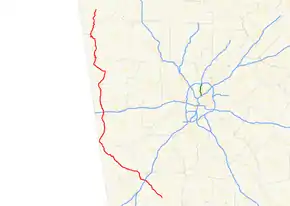
State Route 100 (SR 100) is a 136.5-mile-long (219.7 km) state highway that travels south-to-north through portions of Meriwether, Troup, Heard, Carroll, Haralson, Polk, Floyd, and Chattooga counties in the northwestern part of the U.S. state of Georgia. The route begins at US 27 Alt./SR 18/SR 41/SR 109 in Greenville and ends at US 27/SR 1/SR 114 in Summerville.
| ||||
|---|---|---|---|---|
 | ||||
| Route information | ||||
| Maintained by GDOT | ||||
| Length | 136.5 mi[1] (219.7 km) | |||
| Major junctions | ||||
| South end | ||||
| North end | ||||
| Location | ||||
| Counties | Meriwether, Troup, Heard, Carroll, Haralson, Polk, Floyd, Chattooga | |||
| Highway system | ||||
| ||||

Route description
SR 100 begins at an intersection with US 27 Alt./SR 18/SR 41/SR 109 in Greenville in Meriwether County. Moving north, SR 100 travels concurrent with SR 54 just east of the interchange with Interstate 85 (I-85) east of Hogansville. Once in Hogansville, SR 100 turns north concurrent with US 29/SR 14 for a short distance before continuing northwest alone. Southeast of Franklin, SR 100 joins US 27/SR 1. Just west of Franklin, SR 100, along with SR 34, splits from US 27 and continues west. In less than 1 mile (1.6 km), SR 100 splits from SR 34 and continues northwest. SR 100 continues north and travels concurrent with SR 5 for a short distance east of the Georgia–Alabama state line before continuing north. As SR 100 moves toward Tallapoosa, it crosses I-20, where it is the first eastbound exit in the state for that highway. Crossing US 78 in Tallapoosa, SR 100 travels concurrent with US 27 south of Cedartown. South of Cedartown, SR 100 turns west following US 278 for a brief distance before resuming a northwestern path. In Cave Spring, SR 100 turns west for a brief distance concurrent with US 411 before turning north once again. SR 100 turns west concurrent with SR 20 for a short distance before resuming its northern course toward Summerville. SR 100 ends at the intersection of US 27/SR 114 in Summerville in Chattooga County.[1]
Major intersections
| County | Location | mi[1] | km | Destinations | Notes |
|---|---|---|---|---|---|
| Meriwether | Greenville | 0 | 0.0 | Southern terminus | |
| | 13.2 | 21.2 | Southern end of SR 54 concurrency | ||
| Troup | | 13.8 | 22.2 | I-85 exit 28 | |
| Hogansville | 16.7 | 26.9 | Northern end of SR 54 concurrency; southern end of US 29/SR 14 concurrency | ||
| 17.2 | 27.7 | Northern end of US 29/SR 14 concurrency | |||
| Heard | | 27.1 | 43.6 | Southern end of US 27/SR 1 concurrency | |
| | 29.5 | 47.5 | Northern end of US 27/SR 1 concurrency | ||
| Franklin | 29.5 | 47.5 | Southern end of SR 34 concurrency | ||
| 32.5 | 52.3 | Northern end of SR 34 concurrency | |||
| Carroll | | 51.0 | 82.1 | Southern end of SR 5 concurrency | |
| | 51.5 | 82.9 | Northern end of SR 5 concurrency | ||
| Bowdon | 56.4 | 90.8 | Western terminus of SR 166 | ||
| Haralson | | 66.3 | 106.7 | Western terminus of SR 16 | |
| | 67.2 | 108.1 | I-20 exit 5 | ||
| Tallapoosa | 71.9 | 115.7 | Southern end of US 78/SR 8 concurrency | ||
| 72.1 | 116.0 | Northern end of US 78/SR 8 concurrency | |||
| 72.8 | 117.2 | Western terminus of SR 120 | |||
| Polk | | 88.9 | 143.1 | Southern end of US 27/SR 1 concurrency | |
| Cedartown | 92.2 | 148.4 | Northern end of US 27/SR 1 concurrency; southern end of US 278/SR 6 concurrency | ||
| 93.6 | 150.6 | Northern end of US 278/SR 6 concurrency | |||
| Floyd | Cave Spring | 104 | 167 | Southern end of US 411/SR 53 concurrency | |
| 105 | 169 | Northern end of US 411/SR 53 concurrency | |||
| Coosa | 116 | 187 | Southern end of SR 20 concurrency | ||
| | 119 | 192 | Northern end of SR 20 concurrency | ||
| Chattooga | Summerville | 135 | 217 | Southern end of SR 114 concurrency | |
| 136 | 219 | Northern terminus; northern end of SR 114 concurrency | |||
1.000 mi = 1.609 km; 1.000 km = 0.621 mi
| |||||
Tallapoosa spur route
| |
|---|---|
| Location | Tallapoosa |
| Length | 0.90 mi[2] (1.4 km) |
State Route 100 Spur (SR 100 Spur) is a 0.9-mile-long (1.4 km) spur route that exists entirely within the southwestern part of Haralson County. Its routing is entirely within the city limits of Tallapoosa.
It begins in the southern portion of Tallapoosa, at an intersection with the SR 100 mainline (Alewine Avenue). The highway travels to the east-northeast and quickly curves to the northwest. Just past Golf Course Road, the spur curves to the north-northeast and meets its northern terminus, an intersection with US 78/SR 8 (East Atlanta Street) in the eastern part of town.[2]
The entire route is in Tallapoosa, Haralson County.
| mi[2] | km | Destinations | Notes | ||
|---|---|---|---|---|---|
| 0.0 | 0.0 | Southern terminus | |||
| 0.9 | 1.4 | Northern terminus | |||
| 1.000 mi = 1.609 km; 1.000 km = 0.621 mi | |||||
See also
.svg.png.webp) Georgia (U.S. state) portal
Georgia (U.S. state) portal U.S. roads portal
References
- Google (June 5, 2014). "Route of SR 100 (Greenville to Coosa)" (Map). Google Maps. Google. Retrieved June 5, 2014.
Google (June 5, 2014). "Route of SR 100 (Coosa to Summerville)" (Map). Google Maps. Google. Retrieved June 5, 2014. - Google (April 15, 2014). "Route of SR 100 Spur" (Map). Google Maps. Google. Retrieved April 15, 2014.
External links
 Media related to Georgia State Route 100 at Wikimedia Commons