Georgia State Route 114
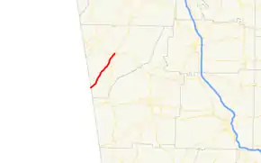
State Route 114 (SR 114) is a 12.7-mile-long (20.4 km) state highway located entirely within Chattooga County in the northwestern part of the U.S. state of Georgia.
| ||||
|---|---|---|---|---|
 | ||||
| Route information | ||||
| Maintained by GDOT | ||||
| Length | 12.7 mi[1] (20.4 km) | |||
| Major junctions | ||||
| South end | ||||
| North end | ||||
| Location | ||||
| Counties | Chattooga | |||
| Highway system | ||||
| ||||

Route description
The route begins at the Alabama state line as a continuation of Alabama State Route 68. The highway runs parallel to the Chattooga River, going through the towns of Chattoogaville and Lyerly before reaching Summerville. In Summerville, SR 100 has a short concurrency with SR 114 until they both reach their northern terminus at an intersection with US 27/SR 1.
SR 114 is not part of the National Highway System, a system of roadways important to the nation's economy, defense, and mobility.[2]
Major intersections
The entire route is in Chattooga County.
| Location | mi[1] | km | Destinations | Notes | |
|---|---|---|---|---|---|
| Chattoogaville | 0.0 | 0.0 | Continuation into Alabama | ||
| Summerville | 12.2 | 19.6 | Southern end of SR 100 concurrency | ||
| 12.7 | 20.4 | Northern terminus; northern end of SR 100 concurrency | |||
1.000 mi = 1.609 km; 1.000 km = 0.621 mi
| |||||
See also
.svg.png.webp) Georgia (U.S. state) portal
Georgia (U.S. state) portal U.S. roads portal
References
- Google (June 14, 2013). "Route of SR 114" (Map). Google Maps. Google. Retrieved June 14, 2013.
- "National Highway System: Georgia" (PDF). United States Department of Transportation. May 8, 2009. Retrieved June 14, 2013.
External links
This article is issued from Wikipedia. The text is licensed under Creative Commons - Attribution - Sharealike. Additional terms may apply for the media files.