Georgia State Route 113
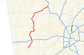
State Route 113 (SR 113) is a state highway in western Georgia. It is a 69-mile-long (111 km) route, connecting US 27/SR 1 in Carrollton and Interstate 75 (I-75) in Cartersville.
| ||||
|---|---|---|---|---|
 | ||||
| Route information | ||||
| Maintained by GDOT | ||||
| Length | 58.10 mi[1] (93.50 km) | |||
| Major junctions | ||||
| South end | ||||
| North end | ||||
| Location | ||||
| Counties | Carroll, Haralson, Paulding, Polk, Bartow | |||
| Highway system | ||||
| ||||

Route description

SR 113 begins at an intersection with US 27/SR 1 in Carrollton. The highway travels north, intersects I-20, then travels through the town of Temple. In extreme eastern Haralson County, the route begins a concurrency with SR 120 traveling east, then travels concurrent with SR 101 northward. North of Yorkville, SR 101/SR 113 also travels concurrent with US 278/SR 6 to Rockmart. The highway departs Rockmart to the northeast. After crossing the Etowah River, the highway travels through downtown Cartersville as Main Street, before reaching its northern terminus at I-75 in the eastern part of Cartersville. SR 113 is usually marked as a north–south signed highway, but in areas like Taylorsville, the highway is signed as an east–west route. It is also signed as an east–west highway at its northern terminus at I-75.
Major intersections
| County | Location | mi[1] | km | Destinations | Notes |
|---|---|---|---|---|---|
| Carroll | Carrollton | 0 | 0.0 | Southern terminus | |
| 1.1 | 1.8 | ||||
| Temple | 9.3 | 15.0 | I-20 exit 19 | ||
| 10.3 | 16.6 | ||||
| 10.9 | 17.5 | South end of SR 274 concurrency | |||
| 11.1 | 17.9 | North end of SR 274 concurrency | |||
| Haralson | Draketown | 18.4 | 29.6 | South end of SR 120 concurrency | |
| Paulding | Union | 22.2 | 35.7 | North end of SR 120 concurrency; south end of SR 101 concurrency | |
| Polk | | 31.6 | 50.9 | South end of US 278/SR 6 concurrency | |
| Rockmart | 32.5 | 52.3 | North end of SR 101 and US 278/SR 6 concurrencies | ||
| Bartow | | 51.4 | 82.7 | South end of SR 61 concurrency | |
| Cartersville | 55.4 | 89.2 | South end of SR 293 concurrency | ||
| 55.8 | 89.8 | North end of SR 61 and SR 293 concurrencies | |||
| 56.7 | 91.2 | ||||
| 58.1 | 93.5 | Northern terminus; I-75 exit 288 | |||
1.000 mi = 1.609 km; 1.000 km = 0.621 mi
| |||||
See also
.svg.png.webp) Georgia (U.S. state) portal
Georgia (U.S. state) portal U.S. roads portal
References
- Google (31 October 2012). "GA-113" (Map). Google Maps. Google. Retrieved 31 October 2012.
External links
 Media related to Georgia State Route 113 at Wikimedia Commons