Georgia State Route 142
State Route 142 (SR 142) is a 36.2-mile-long (58.3 km) state highway that runs northwest-southeast in the central part of the U.S. state of Georgia, within portions of Newton, Jasper, Putnam counties.
| ||||
|---|---|---|---|---|
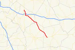 Georgia State Route 142 identified in red | ||||
| Route information | ||||
| Maintained by GDOT | ||||
| Length | 36.2 mi[1] (58.3 km) | |||
| Major junctions | ||||
| West end | ||||
| East end | ||||
| Location | ||||
| Counties | Newton, Jasper, Putnam | |||
| Highway system | ||||
| ||||

Route description
SR 142 begins at an intersection with SR 81, north of Covington, in Newton County. It heads southeast to first meet Interstate 20 (I-20) and then U.S. Route 278 (US 278)/SR 12 in Covington. The three routes head east concurrently and cross over the Alcovy River. SR 142 splits off to the southeast and meets SR 11 (Lamar Hays Memorial Parkway). SR 142 continues to the southeast and intersects SR 213 and SR 229 in Newborn. SR 142 and SR 229 run concurrent through town, and then enter Jasper County. After SR 142 splits off to the southeast, it enters Shady Dale, where it intersects SR 83 (Main Street). The highway enters Putnam County and intersects the route of former SR 300 (Glades Road) in Oconee National Forest. SR 142 continues to the southeast, until it meets its eastern terminus, and intersection with SR 16 (Monticello Road) in Willard, which is located west of Eatonton.[1]
History
A $12 million widening project was announced in 2009 with a scheduled completion in 2012.[2]
Major intersections
| County | Location | mi[1] | km | Destinations | Notes |
|---|---|---|---|---|---|
| Newton | | 0.0 | 0.0 | Western terminus | |
| Covington | 4.6 | 7.4 | I-20 exit 93 | ||
| 5.7 | 9.2 | Western end of US 278/SR 12 concurrency | |||
| | 7.3 | 11.7 | Alcovy River | ||
| | 8.0 | 12.9 | Eastern end of US 278/SR 12 concurrency; eastern terminus of SR 36 | ||
| | 12.3 | 19.8 | |||
| Newborn | 15.5 | 24.9 | Western end of SR 229 concurrency; eastern terminus of SR 213 | ||
| Jasper | | 20.8 | 33.5 | Eastern end of SR 229 concurrency | |
| Shady Dale | 26.7 | 43.0 | |||
| Putnam | Willard | 36.2 | 58.3 | Eastern terminus | |
1.000 mi = 1.609 km; 1.000 km = 0.621 mi
| |||||
See also
.svg.png.webp) Georgia (U.S. state) portal
Georgia (U.S. state) portal U.S. roads portal
References
- Google (June 28, 2013). "Route of SR 142" (Map). Google Maps. Google. Retrieved June 28, 2013.
- Mc Nure, Cissy (February 3, 2009). "ARRA Funded SR 142 Widening Project to Begin" (PDF) (Press release). Georgia Department of Transportation. Archived from the original (PDF) on May 28, 2010. Retrieved June 28, 2013.