Georgia State Route 78
State Route 78 (SR 78) is a 59.6-mile-long (95.9 km) backward question mark-shaped state highway in the southeast part of the U.S. state of Georgia. The highway travels from Soperton north and northwest to Wrightsville, then turning northeast to Wadley and, finally, east, to its eastern terminus, at a point northwest of Midville.
| ||||
|---|---|---|---|---|
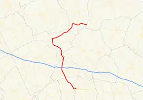 Georgia State Route 78 highlighted in red | ||||
| Route information | ||||
| Maintained by GDOT | ||||
| Length | 59.6 mi[1] (95.9 km) | |||
| Major junctions | ||||
| South end | ||||
| North end | ||||
| Location | ||||
| Counties | Treutlen, Emanuel, Johnson, Jefferson, Burke | |||
| Highway system | ||||
| ||||

Route description
SR 78 begins at an intersection with SR 46 in the northeast part of Soperton. It heads south, southwest, and northwest to an intersection with U.S. Route 221 (US 221)/SR 15/SR 56 in downtown Soperton. At this point, SR 15 begins a long concurrency with SR 78 to Wrightsville. Two blocks later, SR 78 has a second intersection with SR 46. North of Soperton, SR 78 has an interchange with Interstate 16 (I-16). South of Adrian, SR 86 crosses SR 78's path. When the route arrives in Adrian, it intersects US 80/SR 26. To the northwest, in Wrightsville, SR 78 intersects SR 57. The two routes have a one-block concurrency to the intersection of US 319/SR 15/SR 31. At this intersection, US 319/SR 78 begin a concurrency to the northeast.
South of Bartow, US 221/SR 171 join the concurrency. The four routes head north toward Bartow. Just south of the town, they intersect SR 242. In the town, US 319/SR 78turn to the east, while US 221/SR 171 head north. In Wadley, they intersect US 1 BUS/SR 4 BUS and then the US 1/SR 4 mainline. At the latter intersection, US 319 ends. East of the city, SR 78 meets its northern terminus, at an intersection with SR 17 northwest of Midville[1]
The only portion of SR 78 that is part of the National Highway System, a system of routes determined to be the most important for the nation's economy, mobility, and defense, is the concurrency with SR 15 from Soperton to Wrightsville.[2]
Major intersections
| County | Location | mi[1] | km | Destinations | Notes |
|---|---|---|---|---|---|
| Treutlen | Soperton | 0.0 | 0.0 | Southern terminus | |
| 1.0 | 1.6 | Southern end of SR 15 concurrency | |||
| 1.2 | 1.9 | ||||
| | 5.0 | 8.0 | I-16 exit 71 | ||
| | 8.5 | 13.7 | |||
| Emanuel | Adrian | 12.0 | 19.3 | ||
| Johnson | Wrightsville | 29.2 | 47.0 | Southern end of SR 57 concurrency | |
| 29.3 | 47.2 | Northern end of SR 15 and SR 57 concurrencies; southern end of US 319 concurrency; northern terminus of SR 31 | |||
| Jefferson | | 44.6 | 71.8 | Southern end of US 221/SR 171 concurrency | |
| | 47.9 | 77.1 | |||
| Bartow | 48.2 | 77.6 | Northern end of US 221/SR 171 concurrency | ||
| Wadley | 52.4 | 84.3 | |||
| 53.0 | 85.3 | Northern end of US 319 concurrency; northern terminus of US 319 | |||
| Burke | | 59.6 | 95.9 | Northern terminus of SR 78; northern terminus of Robert Johnson Road | |
1.000 mi = 1.609 km; 1.000 km = 0.621 mi
| |||||
See also
.svg.png.webp) Georgia (U.S. state) portal
Georgia (U.S. state) portal U.S. roads portal
References
- Google (October 12, 2012). "Overview map of SR 78" (Map). Google Maps. Google. Retrieved October 12, 2012.
- National Highway System: Georgia (PDF) (Map). Federal Highway Administration. May 8, 2019. Retrieved November 18, 2019.