Interstate 16
Interstate 16 (I-16), also known as Jim Gillis Historic Savannah Parkway, is an east–west Interstate Highway located entirely within the U.S. state of Georgia.[3] It carries the hidden designation of State Route 404 (SR 404) for its entire length. I-16 travels from downtown Macon, at an interchange with I-75 and SR 540 to downtown Savannah at Montgomery Street (Exit 167B).[4] It connects Macon and Savannah, via Dublin, Metter, and Pooler. I-16's unsigned designation of SR 404 has a spur that is signed in Savannah.
| |||||||
|---|---|---|---|---|---|---|---|
| Jim Gillis Historic Savannah Parkway | |||||||
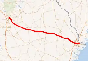
I-16 highlighted in red | |||||||
| Route information | |||||||
| Maintained by GDOT | |||||||
| Length | 166.81 mi[1] (268.45 km) | ||||||
| Existed | 1966[2]–present | ||||||
| Major junctions | |||||||
| West end | |||||||
| |||||||
| East end | Montgomery Street in Savannah | ||||||
| Location | |||||||
| Counties | Bibb, Twiggs, Bleckley, Laurens, Treutlen, Emanuel, Candler, Bulloch, Bryan, Effingham, Chatham | ||||||
| Highway system | |||||||
| |||||||

The westernmost segment in Macon, from I-75 and US 80/SR 87, is part of the Fall Line Freeway, a highway that connects Columbus and Augusta. This segment may also be incorporated into the proposed eastern extension of I-14, which is currently entirely within Central Texas and may be extended to Augusta.[5]
Route description
Bibb County
I-16 begins at an interchange with I-75/SR 540, just northwest of downtown Macon, in Bibb County. Here, it begins a concurrency with SR 540. The Interstate and SR 540 proceed southeast, traveling just east of the downtown area. They cross over the Ocmulgee River and then have an interchange with US 23/US 129/SR 49 (Spring Street/North Avenue). Then, they have a partial interchange with SR 22 (2nd Street) that is only accessible from the westbound lanes. Almost immediately is an interchange with US 80/SR 87 (Martin Luther King Jr. Boulevard/Coliseum Drive). At this intersection, SR 540 departs the concurrency to the north-northeast. Within the eastern part of this interchange, the highway travels under a railroad bridge that carries railroad tracks of Norfolk Southern Railway. In the east-central part of Macon, I-16 travels through Ocmulgee Mounds National Historical Park but without direct access. Visitors need to first exit at the US 80/SR 87 exit. On the southern edge of the national monument, it crosses over Walnut Creek. It then travels on a bridge over some railroad tracks of CSX and Boggy Branch. After leaving Macon, I-16 curves to the south-southeast and has an interchange with US 23/US 129 Alt./SR 87 (Ocmulgee East Boulevard). In the interchange, the highway crosses over Swift Creek. It crosses over Stone Creek before entering Twiggs County.[4]
Twiggs, Bleckley, and Laurens counties
I-16 curves back to the southeast and has an interchange with Sgoda Road. It crosses over Flat Creek and then has an interchange with Jeffersonville and Bullard roads. It curves to the east-southeast and crosses over Savage and Turvin creeks. It then curves back to the southeast. The highway has an interchange with SR 96. Almost immediately, it crosses over Richland Creek. It then has an interchange with SR 358. I-16 curves to the east-southeast and enters Bleckley County just before it has an interchange with SR 112 just south of Allentown. It then crosses over Rocky Creek just before entering Laurens County. The interstate curves back to the southeast and crosses under SR 278 before it travels south of Montrose. It crosses over Bay Branch just before an interchange with SR 26. It then enters the southwestern part of Dudley. There, it has an interchange with SR 338. I-16 curves back to the east-southeast and crosses over Little Rocky Creek just before a rest area. Just to the west-northwest of a crossing of Turkey Creek, the westbound lanes have a rest area. On the southwestern edge of Dublin, the highway has an interchange with SR 257. On the southern edge of the city are interchanges with US 319/US 441/SR 31. and SR 19 (Martin Luther King Jr. Drive). It then crosses over the Oconee River. It has an interchange with SR 199 (Old River Road) just before a crossing of Pughes Creek. Southeast of that is a crossing of Red Hill Creek. Just south of Rockledge, the highway crosses over Mercer Creek. On the eastern edge of the Creek, it enters Treutlen County.[4]
Treutlen County
I-16 curves to the east-northeast and crosses over some railroad tracks of CSX before an interchange with SR 29. It immediately curves back to the east-southeast. It crosses over Red Bluff Creek. Then is an interchange with SR 15/SR 78. The highway travels south of Sand Hill Lake before curving to the east-northeast. It crosses over Pendleton Creek and travels under a bridge that carries SR 86. Then, it begins to curve to the southeast. It has an interchange with US 221/SR 56. It crosses over Reedy Creek and curves to the east-southeast. It has an interchange with SR 297. At the overpass for SR 297, the highway enters Emanuel County.[4]
Emanuel County
After the SR 297 interchange, I-16 heads more to the southeast. It curves to a nearly due east direction and crosses over the Ohoopee River. Just after crossing over some railroad tracks of Norfolk Southern Railway, it enters the city limits of Oak Park. It curves to the southeast and has an interchange with US 1/SR 4/SR 46. After this interchange, the highway begins to parallel SR 46. It curves to the east-southeast and crosses over Jacks Creek. Then, it enters Candler County.[4]
Candler County
I-16 has an interchange with SR 57 (Aline Road). It crosses over Wolfe Creek and then heads to the east-northeast. It crosses over the Canoochee River and curves to a nearly due east direction. It crosses over Sams Creek before entering Metter. As soon as it enters Metter, it passes the Metter Municipal Airport. Right after the airport is an interchange with SR 23/SR 121. On the southeastern edge of Metter, I-16 travels under a bridge that carries SR 129. It crosses over 15 Mile Creek and then curves to the southeast. It crosses over Tenmile Creek and has an interchange with Pulaski–Excelsior Road just before entering Bulloch County.[4]
Bulloch County
The Interstate curves to the east-southeast and has an interchange with US 25/US 301/SR 73. Then, it crosses over Lotts and Little Lotts creeks. It then travels northeast of Nevils. It briefly curves to the east-southeast, where it has an interchange with SR 67, and then curves back to the southeast. It crosses over DeLoach Branch and then curves to the east-southeast. It crosses over Luke Branch and then Boggy Branch before curving to a nearly due east direction. It has an interchange with Ash Branch Church Road. After a crossing of Ash Branch, the highway curves to the east-southeast. It has an interchange with SR 119 just before entering Bryan County.[4]
Bryan, Effingham, and Chatham counties

Almost immediately, the highway crosses over Black Creek. It then curves to the southeast and has an interchange with US 280/SR 30 southwest of Blitchton. It crosses over some railroad tracks of CSX and then crosses over the Ogeechee River, which marks the Effingham County line. It has an interchange with Old River Road south of Meldrim and then enters Chatham County. The first city in the county that I-16 enters is Bloomingdale. There, it has an interchange with SR 17 (Bloomingdale Road). It crosses over the Little Ogeechee River. It very briefly travels along the Bloomingdale–Pooler city line before entering Pooler proper. It has an interchange with Pooler Parkway. It crosses over the Savannah–Ogeechee Canal just before an interchange with I-95. Here, I-16 begins traveling along the southern edge of the city limits of Pooler. Right after the I-95 interchange, the highway crosses over the Hardin Canal. At an interchange with SR 307 (Dean Forest Road), I-16 begins traveling along the Savannah–Garden City line. It briefly enters the city limits of Savannah before traveling along the Savannah–Garden City line again. It has an interchange with the Chatham Parkway. It then re-enters Savannah and curves to the east-southeast. It crosses over some railroad tracks of CSX just before an interchange with I-516/US 17/US 80/SR 21/SR 25/SR 26 (W.F. Lynes Parkway). Here, US 17 begins a concurrency with I-16. It crosses over the Springfield Canal just before a partial interchange with SR 204 (West 37th Street). This interchange is only accessible from the eastbound lanes. I-16/US 17 curves to the northeast. At the next interchange, US 17 splits off, where SR 404 Spur begins. This interchange also provides access to Gwinnett Street. The highway has an interchange with Martin Luther King Jr. Boulevard. The westbound access for this highway is at the eastern terminus. I-16 curves to the north-northeast and reaches its eastern terminus, an interchange with Montgomery Street in downtown Savannah.[4]
Miscellaneous notes
I-16 serves as a hurricane evacuation route for Savannah and other coastal areas. The road is designed for contraflow travel with railroad-type gates to block most entrance and exit ramps for the normally eastbound lanes. During hurricane evacuation, I-16 is converted into westbound traffic from Savannah to west of US 441 in Dublin (exit 51), a total of 125 miles.[6]
I-16's only two rest areas are between exits 42 and 49 near Dudley.[7]
All of I-16 is included as part of the National Highway System, a system of routes determined to be the most important for the nation's economy, mobility, and defense.[8][9][10]
History
The first part of I-16 opened October 11, 1966 to traffic between US 319 (exit 51) in Dublin to SR 29 (exit 67) near Rockledge.[2] In 1968, the segment between US 280 to downtown Savannah was completed and opened.[11] By the early 1970s, I-16 was completed from downtown Macon at I-75 to Jeffersonville Road near Danville. It was also extended from Dublin to Allentown.[12][13] In 1973, the connection between Macon to Dublin was completed.[14] The last part of the I-16 opened on September 22, 1978, placing it in Emanuel, Candler, and Bulloch counties and completing the connection between downtown Macon and Savannah.[15]
Until 2000, the state of Georgia used the sequential interchange numbering system on all of its Interstate Highways. The first exit on each highway would begin with the number "1" and increase numerically with each exit. In 2000, the Georgia Department of Transportation switched to a mileage-based exit system, in which the exit number corresponded to the nearest milepost.[16]
In 2001 the Georgia General Assembly passed a resolution,[17][18] to designate the Earl T. Shinhoster Interchange at the interchange with Martin Luther King, Jr. Boulevard in Savannah in honor of Earl Shinhoster, who was a Black civil rights activist. This interchange is located in the economic and cultural center for Black Savannah.[19]
In 2003, the Georgia General Assembly passed a resolution[20] to designate I-16 in honor of James L. Gillis, Sr., a Democrat who served as a state representative, state senator, and director of the Georgia Department of Transportation, as the Jim Gillis Historic Savannah Parkway.[21] Gillis' sons, Hugh and James, Jr., also served as Democratic state legislators. Hugh was a state representative from 1941 to 1953 and a state senator from 1953 to 1955 and from 1963 to 2005. James, Jr. was a state senator from 1945 to 1946.[22]
In 1999, Hurricane Floyd hit Georgia's coast. As a result, the eastbound I-16 lanes from Savannah to US 1 (exit 90) were opened to westbound traffic. This marked the first time I-16 was turned into a one-way interstate.[23] This contraflow traffic method has been used since, including in 2016 in evacuation efforts from Hurricane Matthew and 2017 for Hurricane Irma.[24][25]
Future
I-95 interchange
Due to high congestion during rush hour in Savannah and many deadly car accidents, the Georgia Department of Transportation (GDOT) has undertaken a new construction project at the interchange of I-95 and I-16 (exit 157 on I-16), along with other I-16 improvements.[26] The project includes:[27][28]
- The widening of I-16 from two lanes in each direction to three lanes between the junctions with I-95 and I-516 (exit 164).
- The construction of a turbine interchange (whirlpool interchange) at the junction of I-16 and I-95, in which two existing loop ramps, from I-16 westbound to I-95 southbound, and from I-95 southbound to I-16 eastbound, will be replaced with turbine configuration ramps.
- The construction of a two-lane emergency median cross-over for westbound I-16 traffic between Dean Forest Road/SR 307 (exit 160) and I-95, to be used to assist in hurricane evacuations from Savannah.
- The creation of a collector-distributor road on I-95 northbound to separate through traffic from cars exiting onto and entering from I-16.
- The reconstruction of six bridges, replacement of four bridges, and the construction of three new bridges near the area.
- The addition of new interchange lighting and Intelligent Transportation System technology to provide real-time driving conditions to travelers.
The project, upon completion, is expected to result in a 32% decrease in I-16 congestion by 2030.[28] Despite concerns from residents, no new noise barriers will be built along I-16 during the construction.[29] A noise study concluded that barriers would not be necessary since traffic noise were not predicted to be over 66 dB(A).[30]
The project is expected to cost around $295 million.[31] Construction, which will be completed by Savannah Mobility Contractors JV, will begin in the second half of 2019 and will be completed in 2022.[32]
I-75 interchange
The interchange of I-75 and I-16 is also undergoing construction, split into six phases, with the first three phases being worked on simultaneously and set to be completed by the end of 2021:[33]
- Phase 1: A collector-distributor road is being built on I-16 eastbound between the I-75 junction and Spring Street (exit 1A), including new bridges over the Ocmulgee River and Spring Street. The Spring Street loop ramp has been temporarily closed and replaced with a temporary left turn onto I-16 westbound. Also, the bridge over the Ocmulgee River on Martin Luther King, Jr. Boulevard is being reconstructed and widened in this phase.
- Phase 2: Construction includes improvements on I-75 between Hardeman Avenue (exit 164) and I-16 (exit 165) and the shifting of exit ramps from I-75 in each direction to I-16. Later in this phase, access to Spring Street for traffic coming from southbound I-75 via I-16 will be temporarily closed to allow for completion of the collector-distributor system.
- Phase 3: A new collector-distributor road is being built along I-75 north through the I-16 interchange, along with a new westbound collector-distributor road from Spring Street along I-16 over the Ocmulgee River and portions of other ramps.
Construction on phase 1 is being completed by C.W. Matthews at a cost of $63 million, while construction on phases 2 and 3 is being completed by E.R. Snell Company for $156 million.
Three additional phases are included in the project, which ultimately are intended to help improve access to and from downtown Macon and Gray Highway via the currently-underutilized Second Street bridge, reducing congestion on Spring Street and North Avenue:[33]
- Phase 4: Bids for a construction contract are scheduled to occur in 2021. Second Street will be widened and ramps from and to eastbound I-16 will be constructed. Construction from Phase 1 and Phase 2 will be completed, along with the collector-distributor road through the I-75 interchange along eastbound I-16 to the Coliseum Drive/Martin Luther King, Jr. Boulevard exit. Access from I-75 southbound via I-16 to Spring Street will be reopened at the conclusion of this phase.
- Phase 5: Bids for a construction contract are scheduled to occur in 2021. During this phase, the Spring Street loop ramp will be reopened and the temporary left turn lane on northbound Spring Street to I-16 westbound will be closed permanently. Also, Phase 3 construction will be completed, and a connection to the north-to-east ramp from Phase 2 will be built. This phase also includes the completion of the westbound collector-distributor road from phase 3, along with a new ramp from Second Street to westbound I-16.
- Phase 6: Bids for a construction contract are scheduled to occur in 2023. A 1,600-foot (490 m) tunnel will be built for the Norfolk Southern Railroad under I-75. All remaining construction will be completed in this phase.
Also as a part of this project, GDOT has spent $12 million in the Pleasant Hill neighborhood to help mitigate the effect of the construction and new highway ramps. The construction, which was completed in the summer of 2018, included the creation of two new parks and the transformation of Penniman House, the childhood home of musician Little Richard, into a community resource center.[34]
Effect of construction on Port of Savannah traffic
According to GDOT, with the expansion of I-16 at its interchanges with I-75, I-95, and I-516, the estimated increase in gross state product (GSP) would be $9,100,000,000 at a cost of $1,950,000,000. In addition, employment would increase annually by 2,426, and the return on investment (ROI) would be 4.7.[35]
Exit list
| County | Location | mi[4] | km | Old exit | New exit | Destinations | Notes |
|---|---|---|---|---|---|---|---|
| Bibb | Macon | 0.0 | 0.0 | 1 | 1 | Western end of SR 540 concurrency; western terminus; left exit 1 is for I-75 south; westbound exit and eastbound entrance; I-75 exit 165; tri-stack interchange | |
| 0.7 | 1.1 | 2 | 1A | No westbound exit or eastbound entrance from southbound Spring Street | |||
| 1.1 | 1.8 | 2 | 1A | Former westbound exit to Second Street northbound only; replaced by Coliseum Drive ramps | |||
| 1.0 | 1.6 | 3 | 1B | Westbound exit only | |||
| 1.3 | 2.1 | 4 | 2 | Eastern end of SR 540 concurrency; Phil Walden Memorial Interchange | |||
| | 5.4 | 8.7 | 5 | 6 | |||
| Twiggs | | 11.3 | 18.2 | 6 | 12 | Sgoda Road – Huber | |
| | 17.4 | 28.0 | 7 | 18 | Bullard Road – Jeffersonville | ||
| | 23.1 | 37.2 | 8 | 24 | |||
| | 26.8 | 43.1 | 9 | 27 | |||
| Bleckley | | 31.6 | 50.9 | 10 | 32 | ||
| Laurens | | 38.4 | 61.8 | 11 | 39 | ||
| Dudley | 40.9 | 65.8 | 12 | 42 | |||
| | 44.5 | 71.6 | Rest area | ||||
| | 47.7 | 76.8 | 13 | 49 | |||
| | 50.3 | 81.0 | 14 | 51 | |||
| | 52.6 | 84.7 | 15 | 54 | |||
| | 57.4 | 92.4 | 16 | 58 | |||
| Treutlen | | 65.9 | 106.1 | 17 | 67 | ||
| | 70.1 | 112.8 | 18 | 71 | |||
| | 76.5 | 123.1 | 19 | 78 | |||
| Treutlen–Emanuel county line | | 83.0 | 133.6 | 20 | 84 | ||
| Emanuel | Oak Park | 88.1 | 141.8 | 21 | 90 | ||
| Candler | | 96.7 | 155.6 | 22 | 98 | ||
| Metter | 102.5 | 165.0 | 23 | 104 | |||
| | 109.7 | 176.5 | 24 | 111 | Pulaski–Excelsior Road | ||
| Bulloch | | 114.9 | 184.9 | 25 | 116 | ||
| | 125.0 | 201.2 | 26 | 127 | Eastern terminus of SR 46 | ||
| | 130.2 | 209.5 | 27 | 132 | Ash Branch Church Road | ||
| | 134.9 | 217.1 | 28 | 137 | |||
| Bryan | Ellabell | 140.2 | 225.6 | 29 | 143 | ||
| 141.5 | 227.7 | Truck weigh stations | |||||
| Effingham | | 145.7 | 234.5 | 30 | 148 | Old River Road to US 80 (SR 26) | |
| Chatham | Bloomingdale | 149.6 | 240.8 | 31 | 152 | Southern terminus of SR 17; northern terminus of Little Neck Road; future western terminus of Jimmy DeLoach Parkway[36] | |
| Pooler | 151.9 | 244.5 | 155 | Pooler Parkway | |||
| 154.1 | 248.0 | 32 | 157 | Signed as exits 157A (south) & 157B (north); I-95 exits 99A-B; cloverleaf interchange; Clarence Thomas Interchange | |||
| Garden City | 156.7 | 252.2 | 33 | 160 | |||
| Savannah | 158.9 | 255.7 | 33A | 162 | Chatham Parkway | ||
| 160.3 | 258.0 | 34A | 164A | Western end of US 17 concurrency; I-516 exit 5 | |||
| 160.5 | 258.3 | 34B | 164B | I-516 exit 5 | |||
| 161.6 | 260.1 | 35 | 165 | Eastbound exit and westbound entrance | |||
| 161.9 | 260.6 | 36 | 166 | Eastern end of US 17 concurrency; eastbound exit and westbound entrance; former US 17 Alt.; western terminus of SR 404 Spur | |||
| 162.3 | 261.2 | 37A | 167A | M. L. King Jr. Boulevard / Gaston Street | Eastbound exit and westbound entrance; Earl T. Shinhoster Interchange; former US 17 south/US 80 east/SR 25 south/SR 26 east | ||
| Earl T. Shinhoster Bridge | Bridge over Martin Luther King Jr. Boulevard for the eastbound lanes only | ||||||
| 162.5 | 261.5 | 37B | 167B | Montgomery Street – Savannah Civic Center, Downtown Savannah | Eastern terminus; eastbound exit and westbound entrance; former US 17 north/US 80 west/SR 25 north/SR 26 west | ||
1.000 mi = 1.609 km; 1.000 km = 0.621 mi
| |||||||
Auxiliary routes
Spur route
| |
|---|---|
| Location | Savannah – South Carolina state line |
| Length | 3.070 mi (4.941 km) |
| Existed | 1989[37][38]–present |
State Route 404 Spur (SR 404 Spur) is a 3.07-mile-long (4.94 km) spur route that travels from I-16 exit 166 northward along US 17 to the South Carolina state line. As its number suggests, it is a spur from SR 404, the unsigned route that is designated along the full length of I-16. However, SR 404 Spur is actually a signed highway. Near the northern end is the Talmadge Memorial Bridge.
The entire route is in Savannah, Chatham County. All exits are unnumbered.
| mi[39] | km | Destinations | Notes | ||
|---|---|---|---|---|---|
| 0.000 | 0.000 | Southern end of US 17 concurrency; southern terminus; northbound exit and southbound entrance; I-16 exit 166 | |||
| 0.324 | 0.521 | Gwinnett Street | Northbound exit and southbound entrance; interchange | ||
| 0.952 | 1.532 | Louisville Road – Visitors Center | Northbound exit and southbound entrance; interchange | ||
| 1.277 | 2.055 | Southbound exit and northbound entrance; interchange | |||
| 1.426– 2.489 | 2.295– 4.006 | Talmadge Memorial Bridge over Savannah River | |||
| 2.569 | 4.134 | Hutchinson Island, Convention Center | Interchange | ||
| 3.070 | 4.941 | Northern end of US 17 concurrency; northern terminus at the South Carolina state line (Back River bridge) | |||
1.000 mi = 1.609 km; 1.000 km = 0.621 mi
| |||||
Interstate 516
| |
|---|---|
| Location | Garden City–Savannah, Georgia |
| Length | 6.49 mi[40] (10.44 km) |
| Existed | 1985–present |
Interstate 516 (I-516) is a 6.49-mile-long (10.44 km) auxiliary route from Garden City to DeRenne Avenue in Savannah, Georgia. It is also known as W.F. Lynes Parkway, and has an unsigned designation of State Route 421 (SR 421).
See also
 U.S. roads portal
.svg.png.webp) Georgia (U.S. state) portal
Georgia (U.S. state) portal
References
- Staff (October 31, 2002). "Tabele 1: Main Routes of the Eisenhower National System Of Interstate and Defense Highways". Route Log and Finder List. Federal Highway Administration. Retrieved July 31, 2011.
- State Highway Department of Georgia (January 1966). Official Highway Map (PDF) (Map). Scale not given. Atlanta: State Highway Department of Georgia. Retrieved February 5, 2017.
- Staff (December 31, 2003). Interstate Mileage Report (PDF) (Report). Georgia Department of Transportation. Retrieved August 30, 2015.
- Google (December 21, 2016). "Overview map of I-16" (Map). Google Maps. Google. Retrieved December 21, 2016.
- "14th Amendment Highway". Federal Highway Administration. Retrieved February 10, 2019.
- "Contra-Flow Lanes: I-16 One-Way Driving Guides". www.511ga.org. Retrieved August 13, 2019.
- "Rest Areas". Georgia Department of Transportation. Retrieved August 30, 2015.
- National Highway System: Georgia (PDF) (Map). Federal Highway Administration. May 8, 2019. Retrieved August 10, 2019.
- National Highway System: Macon, GA (PDF) (Map). Federal Highway Administration. May 9, 2019. Retrieved August 10, 2019.
- National Highway System: Savannah, GA (PDF) (Map). Federal Highway Administration. May 9, 2019. Retrieved August 10, 2019.
- State Highway Department of Georgia (January 1968). Official Highway Map (PDF) (Map). Scale not given. Atlanta: State Highway Department of Georgia. Retrieved February 9, 2017.
- State Highway Department of Georgia (January 1971). Official Highway Map (PDF) (Map). Scale not given. Atlanta: State Highway Department of Georgia. Retrieved February 9, 2017.
- State Highway Department of Georgia (January 1972). Official Highway Map (PDF) (Map). Scale not given. Atlanta: State Highway Department of Georgia. Retrieved February 9, 2017.
- Georgia Department of Transportation (January 1973). Official Highway Map (PDF) (Map). Scale not given. Atlanta: Georgia Department of Transportation. Retrieved February 9, 2017.
- Georgia Department of Transportation (January 1977). Official Highway Map (PDF) (Map) (1977–1978 ed.). Scale not given. Atlanta: Georgia Department of Transportation. Retrieved February 9, 2017.
- Phillips, Noelle (December 1, 1999). "Interstate Exit Signs to Get New Numbers in Georgia". The Florida Times-Union. Retrieved March 4, 2017.
- House of Representatives (April 19, 2001). "House Resolution 182". Atlanta, GA: Georgia General Assembly. Archived from the original on October 2, 2006. Retrieved February 15, 2008.
- State Senate (April 19, 2001). "Senate Resolution 6". Atlanta, GA: Georgia General Assembly. Archived from the original on February 8, 2012. Retrieved February 15, 2008.
- Elmore, Charles J. (April 26, 2004). "The Ralph Mark Gilbert Civil Rights Museum". The New Georgia Encyclopedia. Georgia Humanities Council and the University of Georgia Press. Retrieved February 15, 2008.
- House of Representatives (March 27, 2003). "House Resolution 88". Atlanta, GA: Georgia General Assembly. Archived from the original on March 24, 2012. Retrieved February 15, 2008.
- "Interstate 16". Interstate Guide. December 6, 2006. Retrieved February 15, 2008.
- Staff (February 2003). "Senator Hugh M. Gillis (D-SS 20)". Georgia General Assembly. Archived from the original on September 19, 2008. Retrieved February 15, 2008.
- https://planningtools.transportation.org/files/39.pdf
- "The Latest: Georgia turns I-16 into one-way evacuation route". WSBTV. October 6, 2016. Retrieved August 13, 2019.
- Corley, Laura (September 7, 2017). "Parts of I-16 eastbound to close Saturday; lanes to reverse for Hurricane Irma evacuees". The Telegraph. Retrieved August 13, 2019.
- Ray, Brittini. "Proposed I-16 work promises widening, safety". Savannah Morning News. Retrieved August 12, 2019.
- McLoud, Don. "I-16/I-95 rehab to include Ga.'s first turbine interchange". www.equipmentworld.com. Retrieved August 12, 2019.
- "I-16 at I-95 Improvement Projects - MMIP Project". www.dot.ga.gov. Retrieved August 12, 2019.
- Peebles, Will. "GDOT: New lanes on I-16, new I-95 interchange to be completed by 2022". Savannah Morning News. Retrieved August 12, 2019.
- https://www.in.gov/indot/files/Noise%20Barriers%20Brochure.pdf
- Antonacci, Kelly (October 24, 2018). "EXCLUSIVE: New artist rendition of I-16, I-95 interchange project". WSAV-TV. Retrieved August 12, 2019.
- Logan, Zach. "I-16/I-95 project to use new interchange configuration". WTOC. Retrieved August 12, 2019.
- "I-16/I-75 Interchange Project". www.dot.ga.gov. Retrieved August 12, 2019.
- Dunlap, Stanley (October 1, 2018). "Tired of interstate construction? Here's when you can expect it to be finished". The Telegraph. Retrieved August 13, 2019.
- http://www.dot.ga.gov/InvestSmart/Freight/Documents/Plan/Task%205_Recommendations.pdf
- "Surface Transportation Block Grant (STBG) Urban Attributable (Z230) Funds" (PDF). Savannah Metropolitan Planning Commission. January 2017. Retrieved May 13, 2020.
- Georgia Department of Transportation (1988). Official Highway and Transportation Map (PDF) (Map) (1988–1989 ed.). Scale not given. Atlanta: Georgia Department of Transportation. Retrieved March 31, 2017.
- Georgia Department of Transportation (1989). Official Highway and Transportation Map (PDF) (Map) (1989–1990 ed.). Scale not given. Atlanta: Georgia Department of Transportation. Retrieved March 31, 2017.
- "Road Inventory Data" (ESRI OpenFile Geodatabase). Atlanta: Georgia Department of Transportation. 2017. Retrieved August 10, 2019.
- "Table 2: Auxiliary Routes of the Dwight D. Eisenhower National System Of Interstate and Defense Highways as of December 31, 2015". Federal Highway Administration. Retrieved December 21, 2016.
External links
| Wikimedia Commons has media related to Interstate 16. |
| Signed | |
|---|---|
| Unsigned | |
| Lists | |
| Other | |
Major Interstates highlighted | |
