Gerrans Bay to Camels Cove
Gerrans Bay to Camels Cove is a coastal Site of Special Scientific Interest (SSSI) in south Cornwall, England, UK, noted for both its biological and geological interest.[1]
Geography
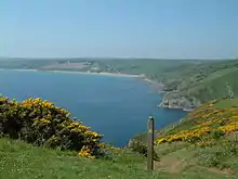
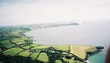
The 139.5-hectare (345-acre) site, notified in 1951, is situated on the south Cornish coast of the English Channel, 6 miles (9.7 km) south-east of the city of Truro. It starts at Creek Stephen Point in the west, following the coast of Gerrans Bay to Nare Head and then on to Manare Point, near Portloe in the east and also includes Gull Rock off the coast.[2][3]
The South West Coast Path runs through the SSSI and most of the coastline is owned by the National Trust.[3]
The site lies within the Cornwall Area of Outstanding Natural Beauty (AONB).
History
This site is an amalgamation of two previous SSSIs; Gerrans Bay to Nare Head SSSI and Camels Cove SSSI.[1]
References
- "Gerrans Bay to Camels Cove" (PDF). Natural England. 27 June 1986. Retrieved 6 December 2011.
- "Gerrans Bay to Camels Cove map". Natural England. Archived from the original on 13 October 2012. Retrieved 6 December 2011.
- Ordnance Survey: Landranger map sheet 204 Truro & Falmouth ISBN 978-0-319-23149-4
Cornwall Portal | |
| Unitary authorities | |
| Major settlements |
|
| Rivers | |
| Topics | |