Giles Weather Station
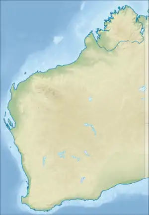
Giles Weather Station (also referred to as Giles Meteorological Station or Giles) is located in Western Australia near the Northern Territory border, about 750 kilometres (470 mi) west-south-west of Alice Springs and 330 kilometres (210 mi) west of Uluru.[4][5] It is the only staffed weather station within an area of about 2,500,000 square kilometres (970,000 sq mi)[6] and is situated mid-continent and near the core of the subtropical jetstream. This means it plays an important role as a weather and climate observatory for the country, particularly eastern and southeastern Australia, and particularly for rainfall predictions. The station is on the Great Central Road and the nearest township is the Warakurna Aboriginal settlement (population 180), 5 kilometres (3 mi) North. Giles is within the Shire of Ngaanyatjarraku and is in the foothills of the Rawlinson Ranges.
| Giles Western Australia | |||||||||
|---|---|---|---|---|---|---|---|---|---|
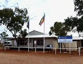 Giles Weather Station in 2011 | |||||||||
 Giles | |||||||||
| Coordinates | 25°02′0″S 128°18′0″E | ||||||||
| Population | 3 (2018)[1] | ||||||||
| Established | 1956 | ||||||||
| Postcode(s) | 0872 | ||||||||
| Elevation | 592 m (1,942 ft)[2] | ||||||||
| Time zone | ACST (UTC+9:30) | ||||||||
| • Summer (DST) | ACDT (UTC+10:30) | ||||||||
| Location |
| ||||||||
| LGA(s) | Shire of Ngaanyatjarraku | ||||||||
| State electorate(s) | Electoral district of Kalgoorlie | ||||||||
| Federal Division(s) | O'Connor | ||||||||
| |||||||||
| Footnotes | Time zone[3] | ||||||||
A staff of three operates the remote station on six-monthly tours.[1] Giles Airport, a 1,600-metre (5,200 ft) airstrip services the station and the Warakurna community.[7]
Tourists are invited to watch the daily release of weather balloons and browse through the Visitor's Centre. Station tours are no longer conducted on a regular basis.
History
Giles is named after English explorer Ernest Giles, the first European to travel through the area in 1874.[8]
Surveyor and roadbuilder Len Beadell, who worked for the Weapons Research Establishment (now known as the Defence Science and Technology Group), selected the site for a meteorological station in December 1955. It was needed to forecast weather conditions suitable for nuclear weapons testing at Emu Field and Maralinga.[4] The location was strongly opposed by Walter MacDougall since it lay on tribal land.[9] Beadell surveyed and built Giles Airport, and chose the name Giles during construction of the Gunbarrel Highway which links Carnegie Station and Giles. Beadell's grader, which is estimated to have travelled over 30,000 kilometres (19,000 miles) in the course of making the roads, was retired in 1963 and is preserved on display at Giles.[10]
Later, the weather station provided support for rocket testing programs at Woomera, as Giles was close to the centre-line of fire from the launch site. Wreckage from the first Blue Streak missile, launched from Woomera on 5 June 1964, is on display at the station.
Docker River, 100 kilometres (62 miles) north-east and just across the state border in the Northern Territory, was established by the government as an aboriginal settlement for local people in the 1960s. Overcrowding there and at Warburton created a need for a new community which became Warakurna in the mid-1970s.
In 1972 control of the station was transferred from the Department of Defence to the Bureau of Meteorology.[4]
A Landline story in 2018 stated that Giles would soon become the last mainland regional weather station to be permanently staffed, with all the others being automated.[1]
Climate
Giles is in an area that has a desert climate (Köppen climate classification BWh) with hot summers and mild winters.[2][11] Rainfall is highly variable; recorded annual values have ranged from 38.0 millimetres (1.50 in) in 1961 to 843.4 millimetres (33.20 in) in 2001.[11] The periodic southward movement of the monsoon trough and ex-tropical cyclones cause heavy rain events in the wetter months from November to March.[11] Dry spells often occur, particularly in winter; the longest period without rain was 125 days from 17 May to 21 September 1961.[11]
| Climate data for Giles Weather Station | |||||||||||||
|---|---|---|---|---|---|---|---|---|---|---|---|---|---|
| Month | Jan | Feb | Mar | Apr | May | Jun | Jul | Aug | Sep | Oct | Nov | Dec | Year |
| Record high °C (°F) | 45.7 (114.3) |
44.4 (111.9) |
44.6 (112.3) |
38.3 (100.9) |
33.9 (93.0) |
29.9 (85.8) |
30.8 (87.4) |
33.2 (91.8) |
38.2 (100.8) |
41.6 (106.9) |
43.9 (111.0) |
46.8 (116.2) |
46.8 (116.2) |
| Average high °C (°F) | 37.3 (99.1) |
36.1 (97.0) |
33.9 (93.0) |
29.5 (85.1) |
23.8 (74.8) |
20.3 (68.5) |
20.2 (68.4) |
22.8 (73.0) |
27.6 (81.7) |
31.9 (89.4) |
34.4 (93.9) |
35.9 (96.6) |
29.5 (85.1) |
| Average low °C (°F) | 23.6 (74.5) |
22.8 (73.0) |
20.6 (69.1) |
16.5 (61.7) |
11.3 (52.3) |
8.0 (46.4) |
6.9 (44.4) |
8.7 (47.7) |
13.0 (55.4) |
17.3 (63.1) |
20.0 (68.0) |
22.0 (71.6) |
15.9 (60.6) |
| Record low °C (°F) | 11.7 (53.1) |
9.8 (49.6) |
8.9 (48.0) |
5.4 (41.7) |
1.8 (35.2) |
−1.6 (29.1) |
−2.5 (27.5) |
−1.4 (29.5) |
2.0 (35.6) |
5.5 (41.9) |
7.0 (44.6) |
9.5 (49.1) |
−2.5 (27.5) |
| Average precipitation mm (inches) | 33.1 (1.30) |
43.2 (1.70) |
35.2 (1.39) |
17.8 (0.70) |
20.5 (0.81) |
18.1 (0.71) |
10.7 (0.42) |
9.3 (0.37) |
10.3 (0.41) |
15.7 (0.62) |
28.1 (1.11) |
46.6 (1.83) |
289.4 (11.39) |
| Source: Bureau of Meteorology[2] | |||||||||||||
References
- Hose, Nick (24 November 2018). "Welcome to Giles, the loneliest weather station in mainland Australia". Landline. Australian Broadcasting Corporation. Retrieved 24 November 2018.
- "Climate statistics: Giles". Bureau of Meteorology. Retrieved 21 March 2020.
- "Latest Weather Observations Giles*". Bureau of Meteorology. Retrieved 9 April 2016.
- "History of Giles Weather Station". Bureau of Meteorology. Archived from the original on 20 March 2011. Retrieved 23 August 2009.
- "Giles Weather Station - WA". =ExplorOz. Retrieved 23 August 2009.
- "Storm Boys". Landline. Australian Broadcasting Corporation. 15 June 2008. Retrieved 28 December 2018.
- "Giles Weather Station". Shire of Ngaanyatjarraku. Retrieved 16 July 2012.
- Joy, William (1964). The Explorers. Adelaide: Rigby. p. 105. ISBN 0 85179 112 3.
- Lindell, Geoffrey; Bennett, R. L. (2006). Parliament: The Vision in Hindsight. Federation Press. p. 201. ISBN 978-1-862-87406-0.
- Shephard, Mark (1998). A Lifetime in the Bush:The biography of Len Beadell. Adelaide: Corkwood Press. p. 214. ISBN 1876247053.
- "Climate of Giles". Bureau of Meteorology. Archived from the original on 20 March 2011. Retrieved 12 April 2013.
External links
| Wikimedia Commons has media related to Giles Weather Station. |
