Giovanni Francesco Zarbula
Giovanni Francesco Zarbula was a mural painter and sundial designer from Piedmont Italy who created a hundred or more vertical and vertical declining sundials in the French and Italian Alpes between 1830 and 1881. He worked exclusively in Savoy, in Piémont, the Valley of the Ubaye, le Queyras and around Briançon. [1]
Laying out the dial
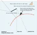
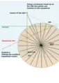
Zarbula's method was one of observation then geometric construction. He did not need to know the latitude or declination of the wall, he did not use tables or calculations he just worked directly on the wall. All his dial were within 2° of the 45th parallel, simplifying the construction, and all gave five-minute accuracy.
- With a plumb bob he drew a vertical line on the wall. This is the "Noon Line".
- He hammered a rod into the wall at right angles to the vertical. This is known as the "centre of the dial", or C
- He observed and marked the shadow thrown by the tip of that rod, throughout a day. This line, technically known as a hyperbolic declination line.[lower-alpha 1]
- Using a set of compasses, he determines the line of symmetry on the wall.[lower-alpha 2] This is the "substyle line".[lower-alpha 3]
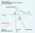
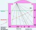
All the rest of the dial was laid out using a 45° square, with a 15° measure at the end. [lower-alpha 4]
- He drew a horizontal line at a point of choice on the dial plate. This was the "Horizon".
- The square was placed on the substyle facing outwards, it is slid into any convenient position where it cuts the horizon, and he drew a perpendicular line drawn to that point. This line is called the "equatorial". A line was drawn from that point to the centre of the dial; it was the 18h line (or 6h depending on the declination (d) of the wall). The points where the equatorial crosses the noon line and where the equatorial crosses the substyle line were important.
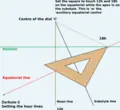
- He placed apex of the square on the substyle line, so the sides passed through the equatorial points mentioned. (The 12h and 18h markers). The apex point is called the "auxiliary equatorial centre".
- A protractor or squares [lower-alpha 5] drew off 15° intervals on the equatorial. These were connected to the centre of the dial: the hour lines. The distance from the auxiliary equatorial centre to the equatorial formed the substyle height at that point.[2][3]
The colours
Zarbula treated his paintings as frescos so the body colour was embedded in the supporting lime mortar. He didn't use organic pigments, just oxides. These do not fade in the strong alpine sunlight.
Existing Dials (cadrans)
Of the hundred dials by Zarbula, about 50 have survived, and a further dozen show visible traces.[4] In Hautes-Alpes, seven dials are protected as monument historique.[5]
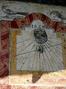
His dials can be divided into three specific styles Öiseau (Birds), Geometric, Baroque. The birds that appear in the dials of the early 1840s include toucans, jabirus, parakeets and other exotic birds not seen in these mountains. The geometric works of the late 1840s and 1850s are noted or their simplicity, and contain a little trompe-l'œil to give the design some artificial depth. The baroque dials are contain birds, vases, full trompe-l'œil and false-marbling. They contain the symbols of the Second Empire (1852-1870) and Napoleon III particularly the Imperial Eagle. The dials produced after 1865 include the Masonic device of the Square and Compasses: this is co-incidental to the rise and acceptance of masonry on both sides of the Italian French border.[6]
| Commune/Village | Lieu-dit/Hameau/Hamlet | Édifice | Region | Country | Date | Protection | Notes | Coords. | Illus. |
|---|---|---|---|---|---|---|---|---|---|
| Briançon | Saint-Blaise | Briançonnais | France | 1870 | Deux cadrans | 44°52′34″N 6°36′48″E | |||
| Briançon | Place d'Armes | Centre d'art contemporain | Briançonnais | France | 1876 | Peut-être inspiré de Zarbula | 44°53′56″N 6°38′34″E | ||
| Briançon | Saint-Blaise | Briançonnais | France | 1870 | 44°52′33″N 6°36′49″E | ||||
| Briançon | Pont-de-Cervières, 4 chemin du Canal-du-Four | Briançonnais | France | 1845 | 44°53′11″N 6°38′16″E | ||||
| Cervières | Maison Delouis | Briançonnais | France | 1839 | Base Mérimée: PA05000001, Ministère français de la Culture. (in French) | Deux cadrans | 44°52′11″N 6°43′22″E | ||
| Cervières | Hôtel de ville | Briançonnais | France | 44°52′10″N 6°43′14″E | |||||
| Eygliers | Le Cros | Briançonnais | France | 1841 | 44°40′55″N 6°37′28″E | ||||
| La Salle-les-Alpes | Les Pananches | Chapelle Saint-Jean-Baptiste | Briançonnais | France | 1879 | Attribué à Zarbula | 44°56′22″N 6°34′57″E | ||
| La Salle-les-Alpes | 38 rue de la Guisane | Briançonnais | France | 1841 | 44°56′44″N 6°33′47″E | ||||
| Puy-Saint-André | Pierre-Feu | Briançonnais | France | 1871 | 44°52′18″N 6°36′00″E | ||||
| Puy-Saint-André | Briançonnais | France | 44°52′45″N 6°35′57″E | ||||||
| Puy-Saint-Pierre | Le Pinet, 2 rue de Jérusalem | Briançonnais | France | 1842 | Base Mérimée: PA00135605, Ministère français de la Culture. (in French) | Deux cadrans | 44°53′26″N 6°37′31″E | ||
| Saint-Chaffrey | Le Villard-Laté, 27 rue des Trois-Fontaines | Briançonnais | France | 1847 | Base Mérimée: PA00135607, Ministère français de la Culture. (in French) | 44°56′12″N 6°35′40″E | |||
| Saint-Martin-de-Queyrières | Bouchier | Briançonnais | France | 1853 | 44°49′58″N 6°33′57″E | ||||
| Saint-Martin-de-Queyrières | Prelles | Briançonnais | France | 1845 | 44°51′17″N 6°34′51″E | ||||
| Saint-Martin-de-Queyrières | Prelles | Briançonnais | France | 44°51′14″N 6°34′49″E | |||||
| Saint-Martin-de-Queyrières | Église Saint-Martin | Briançonnais | France | 44°50′25″N 6°35′07″E | |||||
| Les Orres | Le Mélezet | Église Notre-Dame-de-la-Présentation des Orres | Les Orres | France | 1853 | Base Mérimée: PA05000006, Ministère français de la Culture. (in French) | 44°30′18″N 6°33′12″E | ||
| Arvieux | Le Coin | Maison Jean-Paul Blanc | Queyras | France | 1830 | Superposition de cadrans, l'un d'eux pouvant être de Zarbula | 44°46′21″N 6°43′58″E | ||
| Arvieux | Queyras | France | 1857 | 44°46′01″N 6°44′19″E | |||||
| Arvieux | Les Escoyères | Queyras | France | 1842 | 44°43′08″N 6°44′39″E | ||||
| Arvieux | Les Escoyères | Chapelle Saint-Roch | Queyras | France | 1857 | 44°43′06″N 6°44′35″E | |||
| Château-Ville-Vieille | Ville-Vieille | Queyras | France | Attribué à Zarbula | 44°45′23″N 6°47′22″E | ||||
| Château-Ville-Vieille | Clot-du-Riou | Queyras | France | Base Mérimée: PA00135602, Ministère français de la Culture. (in French) | Deux cadrans | 44°45′54″N 6°46′44″E | |||
| Château-Ville-Vieille | Ville-Vieille | Église Saint-André de Château-Ville-Vieille | Queyras | France | 1843 | 44°45′36″N 6°49′19″E | |||
| Château-Ville-Vieille | Ville-Vieille | Queyras | France | 1843 | 44°45′26″N 6°47′38″E | ||||
| Château-Ville-Vieille | La Rua | Queyras | France | 44°45′37″N 6°49′10″E | |||||
| Molines-en-Queyras | La Rua | Église Saint-Romain | Queyras | France | 1849 | 44°43′53″N 6°50′20″E | |||
| Saint-Véran | Les Forannes, la Pointe du Jour | Queyras | France | 1840 | Base Mérimée: PA05000004, Ministère français de la Culture. (in French) | 44°42′06″N 6°51′58″E | |||
| Saint-Véran | La Raux | Queyras | France | 1840 | 44°41′54″N 6°51′45″E | ||||
| Saint-Véran | Ferme de Mathieu Romain | Queyras | France | 1840 | 44°41′59″N 6°52′06″E | ||||
| Saint-Véran | Haut-Forranes | Queyras | France | 1840 | 44°42′11″N 6°51′54″E | ||||
| Saint-Véran | Pierre-Belle | Queyras | France | 1840 | 44°41′55″N 6°52′09″E | | |||
| Saint-Véran | Les Gabelous | Ancienne douane | Queyras | France | 1858 | 44°41′57″N 6°52′12″E | |||
| Saint-Paul-sur-Ubaye | Petite-Serennes | Ubaye | France | 1860 | 44°31′44″N 6°46′28″E | ||||
| Saint-Paul-sur-Ubaye | Maljasset | Ubaye | France | 1860 | 44°35′34″N 6°50′35″E | ||||
| Pragela | Souchères Basses | Chapelle | Val Cluson | Italie | 1872 | 45°01′47″N 6°57′39″E | |||
| Pragela | Traverse, 6 via Nazionale | Val Cluson | Italie | 45°00′00″N 6°55′34″E | |||||
| Pragela | Villarmont | Val Cluson | Italie | 1872 | 45°00′01″N 6°55′00″E | ||||
| Sauze di Cesana | Rollieres | Chapelle | Val Cluson | Italie | 1870 | Deux cadrans | 44°56′15″N 6°49′56″E | ||
| Sestrières | Champlas du Col, 28 via Nazionale | Val Cluson | Italie | 1870 | 44°56′51″N 6°51′06″E | ||||
| Sestrières | Champlas du Col, 7 via Nazionale | Val Cluson | Italie | 1870 | 44°56′52″N 6°51′10″E | ||||
| Sestrières | Borgata | Val Cluson | Italie | 1872 | 44°58′20″N 6°53′44″E | ||||
| Sestrières | Borgata, 14 via del Colle | Val Cluson | Italie | 1872 | 44°58′20″N 6°53′45″E | ||||
| Sestrières | Borgata, 12a via del Colle | Val Cluson | Italie | 1872 | 44°58′19″N 6°53′44″E | ||||
| Usseaux | Balboutet | Val Cluson | Italie | 1833 | Deux cadrans | 45°03′07″N 7°00′49″E | |||
| Névache | Ville-Haute | Église Saint-Marcellin de Névache | Vallée de la Clarée | France | 45°01′08″N 6°36′17″E | ||||
| Val-des-Prés | Pra-Premier | Vallée de la Clarée | France | 1843 | Base Mérimée: PA00135609, Ministère français de la Culture. (in French) | 44°57′06″N 6°40′32″E | |||
| Val-des-Prés | La Vachette | Vallée de la Clarée | France | 1840 | 44°55′03″N 6°40′31″E | ||||
| Val-des-Prés | La Vachette | Vallée de la Clarée | France | 1852 | 44°55′00″N 6°40′26″E | ||||
| Valloire | Valloire | France | 45°09′55″N 6°25′39″E | ||||||
| Valloire | Les Verneys | Valloire | France | 45°08′59″N 6°25′14″E | |||||
| Vallouise | Maison de Bardonèche | Vallouise | France | 1840 | Base Palissy: IM05003855, Ministère français de la Culture. (in French) | Deux cadrans | 44°50′40″N 6°29′08″E | ||
| Vallouise | Le Villard | Chapelle Saint-Sébastien | Vallouise | France | 1869 | Base Palissy: IM05003852, Ministère français de la Culture. (in French) | Deux cadrans | 44°50′30″N 6°28′22″E | |
| Valserres | Les Trancs | France | 1854 | 44°29′30″N 6°07′24″E |
References
- Footnotes
- Declination of the sun ( δ ) not declination of the wall (d)
- Indian or Hindu Circle for Sub-style determination
- In dialling language substyle is used like sub aqua, meaning- under the style- not like subsection, meaning a smaller part. Similarly, equation means an adjustment and height can mean a perpendicular angle.
- Zarbula was working within 2° of the 45th parallel, so it worked. Further north or south the triangle would need to use the latitude and co-latitude and a protractor would have been needed
- A combination of a 30°/ 60° square, and 45° square could also be used.
- References
- Les Cadrans solaires (ed.). "Giovanni Francesco Zarbula".
- http://www.ens-lyon.fr/RELIE/Cadrans/Promenades/Zarbula/Equerre
- Paul Gagnaire. "L'Équerre et l'Oiseau, l'Art et la Manière de Zarbula".
- Les Cadrans solaires (ed.). "La Technique de G. F. Zarbula".
- "Cadrans solaires de Zarbula protégés aux monuments historiques". Base Mérimée.
- Les Cadrans solaires (ed.). "La Style de G. F. Zarbula".
