Saint-Paul-sur-Ubaye
Saint-Paul-sur-Ubaye is a commune in the Alpes-de-Haute-Provence department in southeastern France.
Saint-Paul-sur-Ubaye | |
|---|---|
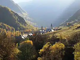 The hamlet of Grande Serenne, in Saint-Paul-sur-Ubaye | |
Location of Saint-Paul-sur-Ubaye 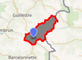
| |
 Saint-Paul-sur-Ubaye  Saint-Paul-sur-Ubaye | |
| Coordinates: 44°30′57″N 6°45′08″E | |
| Country | France |
| Region | Provence-Alpes-Côte d'Azur |
| Department | Alpes-de-Haute-Provence |
| Arrondissement | Barcelonnette |
| Canton | Barcelonnette |
| Intercommunality | Vallée de l'Ubaye |
| Government | |
| • Mayor (2008–2014) | Michel Tiran |
| Area 1 | 205.55 km2 (79.36 sq mi) |
| Population (2017-01-01)[1] | 186 |
| • Density | 0.90/km2 (2.3/sq mi) |
| Time zone | UTC+01:00 (CET) |
| • Summer (DST) | UTC+02:00 (CEST) |
| INSEE/Postal code | 04193 /04530 |
| 1 French Land Register data, which excludes lakes, ponds, glaciers > 1 km2 (0.386 sq mi or 247 acres) and river estuaries. | |
Population
| Year | Pop. | ±% |
|---|---|---|
| 1765 | 1,736 | — |
| 1793 | 1,396 | −19.6% |
| 1800 | 1,850 | +32.5% |
| 1806 | 1,872 | +1.2% |
| 1821 | 1,793 | −4.2% |
| 1831 | 1,802 | +0.5% |
| 1836 | 1,650 | −8.4% |
| 1841 | 1,714 | +3.9% |
| 1846 | 1,612 | −6.0% |
| 1851 | 1,594 | −1.1% |
| 1856 | 1,520 | −4.6% |
| 1861 | 1,512 | −0.5% |
| 1866 | 1,482 | −2.0% |
| 1872 | 1,538 | +3.8% |
| 1876 | 1,259 | −18.1% |
| 1881 | 1,238 | −1.7% |
| 1886 | 1,341 | +8.3% |
| 1891 | 1,064 | −20.7% |
| 1896 | 1,060 | −0.4% |
| 1901 | 987 | −6.9% |
| 1906 | 984 | −0.3% |
| 1911 | 945 | −4.0% |
| 1921 | 764 | −19.2% |
| 1926 | 652 | −14.7% |
| 1931 | 597 | −8.4% |
| 1936 | 560 | −6.2% |
| 1946 | 474 | −15.4% |
| 1954 | 324 | −31.6% |
| 1962 | 238 | −26.5% |
| 1968 | 232 | −2.5% |
| 1975 | 221 | −4.7% |
| 1982 | 208 | −5.9% |
| 1990 | 198 | −4.8% |
| 1999 | 190 | −4.0% |
| 2008 | 228 | +20.0% |
References
- "Populations légales 2017". INSEE. Retrieved 6 January 2020.
| Wikimedia Commons has media related to Saint-Paul-sur-Ubaye. |
This article is issued from Wikipedia. The text is licensed under Creative Commons - Attribution - Sharealike. Additional terms may apply for the media files.