Ubaye
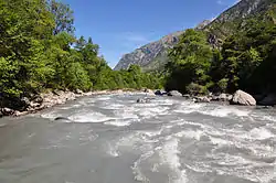
The Ubaye is a river of southeastern France. It is 83 kilometres (52 mi) long and flows through the Alpes-de-Haute-Provence department.[1] Its drainage basin is 1,009 km2 (390 sq mi).[2]
| Ubaye | |
|---|---|
 | |
 | |
| Location | |
| Country | France |
| Physical characteristics | |
| Source | |
| • location | Cottian Alps |
| Mouth | |
• location | Durance |
• coordinates | 44°28′31″N 6°17′52″E |
| Length | 83 km (52 mi) |
| Basin size | 1,009 km2 (390 sq mi) |
| Basin features | |
| Progression | Durance→ Rhône→ Mediterranean Sea |
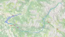
Its rises at the Col de Longet, in the Cottian Alps on the border with Italy. It flows generally southwest, through Saint-Paul-sur-Ubaye, Jausiers and Barcelonnette. It flows into the Lac de Serre-Ponçon (which is fed and drained by the Durance) near La Bréole.
See also
References
- Sandre. "Fiche cours d'eau - L'Ubaye (X04-0400)".
- Bassin versant : Ubaye (L'), Observatoire Régional Eau et Milieux Aquatiques en PACA
External links
This article is issued from Wikipedia. The text is licensed under Creative Commons - Attribution - Sharealike. Additional terms may apply for the media files.
