Golden Triangle of Jakarta
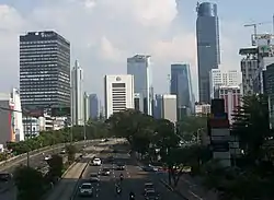
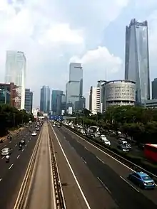
Golden Triangle of Jakarta (Indonesian: Segitiga Emas Jakarta) is roughly a triangular shape land area of Jakarta, Indonesia, which extends from Central Jakarta to South Jakarta. Most of the business, financial, and diplomatic establishments are located in the area, which also forms the center of the city. The area is the main CBD of Jakarta, where most of the tallest skyscrapers are located.[1] The area is bordered by main avenues of Jakarta, Thamrin Avenue-Sudirman Boulevard (North-Southwest), Rasuna Said Avenue (North-Southeast), and Gatot Subroto Avenue (East-West). There are many other roads criss-crossing the area. There are clusters of commercial buildings such as SCBD (45 hectares), Mega Kuningan (54 hectares), Rasuna Epicentrum (53.6 hectares) and Kuningan Persada (17 hectares).[2] Golden triangle is one of the fastest evolving CBD in Asia-Pacific region.[3]
History and geography

During the period between 1960-1965 Jakarta's urban development changed drastically when President Sukarno, also an architect and an urban planner, personally drove the city into a modern capital that would not only be the pride of the Indonesian nation, but would also be a "beacon" of a powerful new nation.[4][5] During 1950s development axis of Jakarta was shifted towards south direction starting from Medan Merdeka to Kebayoran as the center of Jakarta, replacing that of Medan Merdeka-Senen-Salemba-Jatinegara axis which has grown since the 18th century.
Some of the notable infrastructure projects of Sukarno during the first half of the 1960s were, construction of wide avenues like Jalan M.H. Thamrin, Jalan Jenderal Sudirman, Jalan Gatot Subroto and Semanggi "clover-leaf" highway interchange. Jalan H.R. Rasuna Said was being developed in 1970's, which after completion along with Sudirman, and Gatot Subroto roads formed the "golden triangle" of Jakarta. During the period, the earliest signs of building appeared in Sudirman Road north of Semanggi Interchange.[6] The concept of golden triangle has long been formed, at least began to be known in the era of the 1990s.[7] Three points of the triangle which formed the area are,
- Youth statue in Kebayoran Baru, South Jakarta
- Arjuna statue in Merdeka Square, Central Jakarta
- Dirgantara statue in Pancoran, South Jakarta
The golden triangle area of Jakarta includes major roads such as Thamrin, Sudirman, Gatot Subroto, Rasuna Said and Mas Mansyur and Satrio. Administratively the Golden Triangle area is located in Menteng, Tanah Abang, Setiabudi, Kebayoran Baru and Mampang Prapatan sub-district of Jakarta.
Important areas within Golden Triangle
Many commercial centers are developed gradually as clusters within Golden Triangle area, such as Hotel Indonesia roundabout, SCBD, Mega Kuningan. Most of the skyscrapers of Jakarta are located within this triangle.
- Many commercial, shopping and hotels are located in and around Hotel Indonesia roundabout, such as Grand Indonesia, Plaza Indonesia, Thamrin Nine, Hotel Indonesia, Wisma Nusantara, Menara BCA. Embassy of Japan, Germany, and France are situated on Jalan M.H. Thamrin, close to the roundabout. Bank Indonesia headquarter and first high-rise building of Jakarta Sarinah also located at Jalan M.H. Thamrin.
- Numerous high-rise building and skyscrapers are located along Sudirman Avenue, such as Wisma 46, Menara Astra, Sinarmas MSIG Tower, International Financial Center Jakarta, World Trade Center Jakarta, Sahid Sudirman Center.
- SCBD is a mixed development cluster of 45 hectares located at Jalan Jenderal Sudirman. The area has many commercial skyscraper, shopping and entertainment center. District 8, Pacific Place Jakarta, Indonesia Stock Exchange, The Energy, PCPD Tower, Sequis Center Tower, Equity Tower located within the district. As of June, 2017 the 2nd tallest building in Indonesia, Treasury Tower is located in the district at present. Jakarta Signature Tower, which is under construction, once completed this will be the tallest building in the city and 5th tallest building in the world, is also located in the district.[8]
- Legislative seat of Indonesia DPR/MPR Building located in between Jalan Jenderal Sudirman and Jalan Jenderal Gatot Subroto. Gelora Bung Karno Sports Complex, JCC, Plaza Senayan, Senayan City, FX Sudirman, Jakarta Metropolitan Police Headquarter located in and around Senayan area of Golden Triangle.
- Tallest building of Jakarta Gama Tower located at Rasuna Said Road. Foreign embassies of Australia, Malaysia, Singapore, Russia, Poland, Netherlands, Switzerland, Hungary, Bosnia and Herzegovina, Turkey, Algeria, Bangladesh, and India are located at this road.
- Mega Kuningan is a densely concentrated district of high rise buildings with a land area of about 55 hectares. Important buildings in the area are World Capital Tower, BTPN Towers, JW Marriott Jakarta, Ritz-Carlton Hotel, Ciputra World Jakarta complex etc.
- Rasuna Epicentrum is an area of 53.6 hectares, consisting of residential, offices, hotels, hospitals, places of worship, sports, shopping and entertainment and education in one area.
- Gatot Subroto Avenue runs east-west direction within Golden Triangle. It is now going through a transformation of building new skyscrapers. Four Seasons Hotel Tower, Telkom Landmark Complex, The Tower, Mangkuluhur City located in this road.
Transportation
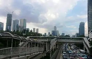
The area is served by TransJakarta Corridor 1, Corridor 6, Corridor 9. There are many routes operated by Kopaja, Mayasari Bakti and APTB buses. Sudirman, Cikini and Gondangdia station of Jakarta commuter rail are located within the area. The North-South line of Jakarta MRT crosses the area with multiple stations. The area will be also served by LRT.
See also
References
- "Segitiga Emas Jakarta Tetap Primadona". Kompas. Retrieved 2017-08-10.
- "Segitiga Emas Jakarta Tetap Jadi Patokan Kawasan Perkantoran". Detik. Retrieved 2017-06-20.
- "Where are the fastest evolving Central Business Districts in Asia Pacific?". Retrieved 2017-06-20.
- Silver 2007, p. 101.
- Sukarno's vision of a modern capital www.thejakartapost.com
- Merrillees 2015, p. 27.
- "Segitiga Emas Jakarta Tetap Jadi Patokan Kawasan Perkantoran". Detik. Retrieved 18 August 2017.
- "SCBD to get world's 5th tallest building". The Jakarta Post. Retrieved 2017-06-28.