South Jakarta
South Jakarta (Indonesian: Jakarta Selatan) is one of the five administrative cities (kota administrasi) which form the Special Capital Region of Jakarta, Indonesia. South Jakarta is not self-governed and does not have a city council, hence it is not classified as a proper municipality. It had a population of 2,062,232 at the 2010 Census;[2] the latest official estimate (for mid 2019) is 2,264,700,[3] and it is the third most populous among the five administrative cities of Jakarta, after East Jakarta and West Jakarta. The administrative centre is at Kebayoran Baru.
South Jakarta | |
|---|---|
| Administrative city of South Jakarta Kota Administrasi Jakarta Selatan | |
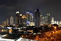 Sudirman Central Business District skyline at night | |
 Seal | |
 | |
| Country | |
| Province | Jakarta |
| Government | |
| • Mayor | Marullah Matali |
| • Vice Mayor | Isnawa Adji |
| Area | |
| • Total | 154.32 km2 (59.58 sq mi) |
| Population (2019)[1] | |
| • Total | 2,264,700 |
| • Density | 15,000/km2 (38,000/sq mi) |
| Time zone | UTC+7 (WIB) |
| Website | selatan.jakarta.go.id |
South Jakarta is bounded by Central Jakarta to the north, East Jakarta to the east, Depok city to the south, West Jakarta to the northwest, and by Tangerang and South Tangerang cities to the west.
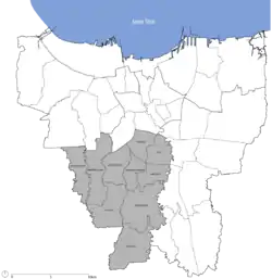
Districts
South Jakarta is subdivided into ten districts (kecamatan), listed below with their areas and their populations at the 2010 Census and according to the mid-2019 official estimates:[4]
| District | Area (km²) | Population (2010 Census) |
Population (2019 Estimate) |
Population density 2019 (/km²) |
|---|---|---|---|---|
| Jagakarsa | 24.87 | 310,220 | 413,300 | 16,618.4 |
| Pasar Minggu | 21.69 | 287,731 | 310,600 | 14,320.0 |
| Cilandak | 18.16 | 189,406 | 203,600 | 11,211.5 |
| Pesanggrahan | 12.76 | 211,761 | 223,900 | 17,547.0 |
| Kebayoran Lama | 16.72 | 293,646 | 309,500 | 18,510.1 |
| Kebayoran Baru | 12.93 | 141,714 | 144,100 | 11,144.6 |
| Mampang Prapatan | 7.73 | 141,859 | 147,900 | 19,133.2 |
| Pancoran | 8.53 | 147,972 | 156,400 | 18,335.3 |
| Tebet | 9.03 | 209,041 | 211,900 | 23,466.2 |
| Setiabudi | 8.85 | 128,882 | 143,600 | 16,214.7 |
| Totals | 154.32 | 2,062,232 | 2,264,700 | 14,675.3 |
Economy
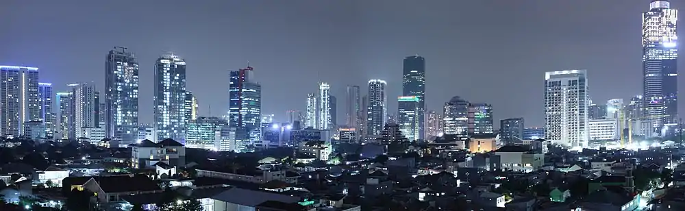
In the days following World War II, South Jakarta was planned to be a satellite city (especially the Kebayoran Baru area) and by using the oriental concept. This area also contains some industrial centers for different types of commodities. South Jakarta is a prosperous administrative city compared to the others, with much middle-to-upper class housing and major business centres.[5] South Jakarta has the highest Human Development Index of all Jakarta's administrative cities, with an HDI of 0.833.[6]
Much of the central business district is concentrated in Setiabudi, South Jakarta, such as Sudirman Central Business District (SCBD) in Senayan, Kebayoran Baru. Initially, SCBD was a service provider and real estate investment, but nowadays, it is becoming the most integrated mixed-use area in Indonesia.[7]
See also
References
- Badan Pusat Statistik, Jakarta, 2020.
- Biro Pusat Statistik, Jakarta, 2011.
- Badan Pusat Statistik, Jakarta, 2020.
- Badan Pusat Statistik, Jakarta, 2020.
- Jakarta, Jakarta Selatan, DKI. "Jakarta Selatan". selatan.jakarta.go.id. Retrieved 2019-03-24.
- "BPS Provinsi DKI Jakarta". 2016-10-03. Archived from the original on 2016-10-03. Retrieved 2019-03-24.
- "Tonggak Sejarah | SCBD - Kawasan Bisnis | CBD Indonesia | Office Building Jakarta | Pusat Bisnis Jakarta". SCBD. Retrieved 2019-03-23.
External links
| Wikivoyage has a travel guide for South Jakarta. |
- (in Indonesian) South Jakarta Community Site www.satujakarta.com
- (in Indonesian) List of Jakarta districts including South Jakarta.
- (in Indonesian) Jasa kirim Mobil jakarta
- (in Indonesian) Asuransi kesehatan terbaik
- SEO Official website