Goosenecks State Park
Goosenecks State Park is a state park in the U.S. state of Utah, overlooking a deep meander of the San Juan River. The park is located near the southern border of the state a short distance from Mexican Hat, Utah.[1] Millions of years ago, the Monument Upwarp forced the river to carve incised meanders over 1,000 feet (300 m) deep as the surrounding landscape slowly rose in elevation. Eroded by water, wind, frost, and gravity, this is a classic location for observing incised meanders.
| Goosenecks State Park | |
|---|---|
IUCN category V (protected landscape/seascape) | |
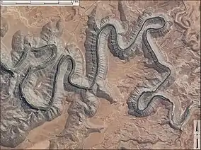 Aerial view of the Goosenecks | |
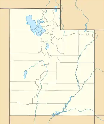 Location of Goosenecks State Park in Utah  Goosenecks State Park (the United States) | |
| Location | San Juan, Utah, United States |
| Coordinates | 37°10′29″N 109°55′37″W |
| Area | 10 acres (4.0 ha)[1] |
| Elevation | 4,500 ft (1,400 m)[2] |
| Established | 1962 |
| Visitors | 63778 (in 2011)[3] |
| Operator | Utah State Parks |
Goosenecks State Park is largely undeveloped. Primitive campsites with picnic tables are scattered back from the edge of the cliff, and vault toilets are available. Campers are advised to bring their own water, food, and other necessary gear.
There are no developed hiking trails in the park,[4] but the Honaker Trail, a few miles to the northwest, provides access to the San Juan River.[5]

References
- Utah.com. "Goosenecks State Park". Utah.com LC. Retrieved 2011-02-05.
- "Goosenecks State Park: About the Park". Utah State Parks. Archived from the original on 2011-03-16. Retrieved 2011-02-05.
- "Utah State Park 2011 Visitation" (PDF). Utah State Parks Planning. Retrieved 28 May 2012.
- Crossley, John. "Goosenecks State Park". Americansouthwest.net. Retrieved 2010-01-18.
- Hopkins, Ralph Lee (2002). Hiking the Southwest's Geology: Four Corners Region. The Mountaineers Books. p. 123. ISBN 978-0-89886-856-2.
External links
 Media related to Goosenecks State Park at Wikimedia Commons
- Goosenecks State Park