Gordonvale, Queensland
Gordonvale is a rural sugar-growing town and locality situated on the southern side of Cairns in the Cairns Region, Queensland, Australia.[2][3] In the 2016 census the locality of Gordonvale had a population of 6,671 people.[1]
| Gordonvale Cairns, Queensland | |||||||||||||||
|---|---|---|---|---|---|---|---|---|---|---|---|---|---|---|---|
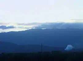 Mulgrave Central Mill and mountains | |||||||||||||||
 Gordonvale | |||||||||||||||
| Coordinates | 17.0936°S 145.7866°E | ||||||||||||||
| Population | 6,671 (2016 census locality)[1] | ||||||||||||||
| • Density | 116.63/km2 (302.06/sq mi) | ||||||||||||||
| Established | 1877 | ||||||||||||||
| Postcode(s) | 4865 | ||||||||||||||
| Elevation | 10 m (33 ft) | ||||||||||||||
| Area | 57.2 km2 (22.1 sq mi) | ||||||||||||||
| Time zone | AEST (UTC+10:00) | ||||||||||||||
| LGA(s) | Cairns Region | ||||||||||||||
| State electorate(s) | Mulgrave | ||||||||||||||
| Federal Division(s) | Kennedy | ||||||||||||||
| |||||||||||||||
Geography
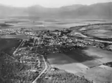
Gordonvale lies approximately 23 kilometres (14 mi) south of the Cairns central business district and is just east of the Gillies Range which leads to the Atherton Tableland.
The locality is bounded to the south-east by the Mulgrave River. The land is generally flat and low-lying (approx 10 metres (33 ft) above sea level), but on the eastern, southern and western boundaries of the locality the land begins to rise sharply as the locality is surrounded by mountainous terrain formating part of a number of ranges: Islet Hills to the north-west, Lamb Range to the south-west, Belleden Ker Range to the south, and Thompson Range to the east. The predominant land use in the locality is growing sugarcane.[4]
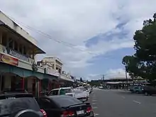
The town of Gordonvale is on the Mulgrave River and is on the south-eastern edge of the locality. The Mulgrave Sugar Mill (17.0931°S 145.7889°E) is on the western side of the town in Gordon Street.[4]
The Bruce Highway enters the locality from the south-east (Aloomba), bypasses the town centre to the west and then proceeds north to exit to Wrights Creek.[4]
The North Coast railway line enters the locality from the south-east (Aloomba), passes through the town and then travels north through the locality to exit to Wrights Creek.[4][5] The town is served by the Gordonvale railway station (17.0932°S 145.7879°E) which is located immediately adjacent to the sugar mill. The Kamma railway siding (17.0522°S 145.7688°E) is just prior to the exit to Wrights Creek. The former Meringa railway station (17.0752°S 145.7757°E) in the centre of the locality has been abandoned.[5] There is an extensive network of cane tramways through the locality and beyond that deliver harvested sugarcane to the Mulgrave Sugar Mill.[4]
History
Gordonvale was established on Yidinji tribal land. Yidinji (also known as Yidinj, Yidiny, and Idindji) is an Australian Aboriginal language. Its traditional language region is within the local government areas of Cairns Region and Tablelands Region, in such localities as Cairns, Gordonvale, and the Mulgrave River, and the southern part of the Atherton Tableland including Atherton and Kairi.[6]
British settlement began in 1877 with William Saunders Alley and Mr Blackwell and their families who cut a road through to Trinity Inlet so they could haul out cedar logs. It was called Plain Camp by Alley.[7] By 1880, the road was well-used by miners and packers and they established the Riverstone Hotel to service the passing trade. After a while, a small town developed, encompassing three pubs, a store and a butcher shop run by John Gordon.
In the Cairns area, a Chinese businessman, Andrew Leon built the first sugar mill in 1882, named Pioneer Mill, and established the Hap Wah Plantation on 612 acres (2.48 km2) of land. Other plantations and sugar mills were also established in the area in years following, and the region developed into a sugar cultivation and milling area.
In 1890 the area became known Mulgrave after the Mulgrave River.[7] In 1896 it was name Nelson, named after Queensland Premier Sir Hugh Muir Nelson.[8] However this caused postal confusion with Nelson in New South Wales. On 24 January 1914 the town was officially renamed Gordonvale after John Gordon, a pioneer in the district who was a butcher, dairyman and grazier and early director of Mulgrave Central sugar mill.[2][3]
In the late 19th century, the Bryce brothers built the town's general store which expanded greatly over the years, supplying the community and farmers with provisions as well as equipment. Also in the late 19th century "Snowy" Thomas and his family built a butcher shop with adjoining bakery that also became the lifeblood of the town and ran a delivery service using horses. Similarly, the Harris brothers ran a mechanical repair store for farming equipment and personal vehicles, another essential service for the small farming community.
Mulgrave State School opened on 15 March 1897.[9] In 1914 it was renamed Gordonvale State School in 1914. On 28 March 1924 it became Gordonvale Rural School. In 1963 a secondary school department was added until a permanent secondary school was established in 1965. On 1 January 1965 it was renamed Gordonvale State School again.[10]
Around 1902, Anthony Abdullah (Simon) moved to Gordonvale with his wife, Mary. The Abdullahs were among the earliest Lebanese families to migrate to Australia, hailing from the tiny village of Kfarsghab.[11] Anthony owned the grounds where today stand St Michael's Catholic Church. The convent was his original family home. He ran a drapery business, and was known locally and with fondness as 'Abdullah the Turk'.[12] The family were great benefactors of the Church. They moved to Sydney in 1923, leaving Gordonvale forever.[13]
Around 1914 the first cinema in the town was established by Vince and Daisy Medlik with the latter's sister Nellie Sutcliffe. Vince Medlik was a carpenter and was the owner-builder. Running silent movies at first, the cinema was called "Vince Medlik's Silent Pictures". As well as movies, once a month they presented a vaudeville night produced by Nellie and the dancers from her dancing school. Displaying a rare technical skill in its time, especially for a woman, Nellie also operated the projection and took care of inaugurating the "talkies" when they later came in. Due to unforeseen circumstances the business had to be moved just before the Great Depression to the newly built and nearby Nelson Hall. It subsequently had to be closed down during the Depression even though by that stage other family members had become involved in its operation such a Vince's son Laurie Medlik. Before the Second World War the cinema reopened with new proprietors and employed Nellie Sutcliffe and Laurie Medlik, the latter managing it.
St Alphonsus Catholic School was established in Muir Street in 1923 by the Sisters of Mercy.[10][14] It was officially opened on Sunday 15 April 1923 by Bishop John Heavey.[15] A special excursion train was provided for people wishing to attend the ceremony.[16] In December 1959 it was replaced by the St Michael's Catholic Primary School an the former school building became a parish hall. The Sisters of Mercy ended their involvement with the school in 1990 and it now operates under lay leadership.[17][18]
Little Mulgrave State School opened on 26 July 1926 and closed on 21 February 1964.[10]
On Sunday 15 July 1934 the Apostolic Delegate, Archbishop Filippo Bernardini laid the foundation stone for a new Catholic Church.[19] On Sunday 27 January 1935 Bishop John Heavey officially opened and blessed the new church.[20] The Gordonvale parish of the Roman Catholic Vicariate Apostolic of Cooktown (now the Roman Catholic Diocese of Cairns) was established in 1935.[21]
Cane toads (Bufo marinus) were deliberately introduced into Australia in an attempt to control the native Frenchi beetle (Lepidiota frenchi) and the greyback cane beetle (Dermolepida albohirtum) whose larvae (colloquially known as "cane grubs") were destroying sugar cane crops in North Queensland. In June 1935 the Queensland Bureau of Sugar Experiment Stations imported 102 cane toads (Bufo marinus) into Gordonvale from Hawaii in June 1935 (with one dying in transit due to dehydration) in the belief that the toads would eat the cane beetles, a pest in the sugarcane industry. By March 1937 some 62,000 toadlets had been bred and distributed into sugar cane fields up and down the Queensland coast. The experiment did not work and the toads have spread throughout much of Australia.[22]
In June 1935 the Queensland Bureau of Sugar Experiment Stations imported 102 cane toads (Bufo marinus) into Gordonvale from Hawaii in June 1935 (with one dying in transit due to dehydration) in the belief that the toads would eat the cane beetles, a pest in the sugarcane industry. By March 1937 some 62,000 toadlets had been bred and distributed into sugar cane fields up and down the Queensland coast. The experiment did not work and the toads have spread throughout much of Australia.[22]
During World War II a contingent of approximately 3,000 American paratroopers was stationed in Gordonvale and did their training there for their missions in New Guinea. The American Army commandeered some of the town's hotels to use as hospitals as many troops were injured during this training. Quite a number of local women were employed to do parachute packing.
The Gordonvale Library opened on 19 February 1954, replacing the old School of Arts which was built in 1900.[23][24]
All Saints' Anglican Church was consecrate on 14 June 1963 by Anglican Bishop of North Queensland Ian Shevill and Anglican Archbishop of Sydney Hugh Gough. It was designed by Cairns architects Sidney George Barnes and Edwin Oribin.[25]
On 26 October 1964 Senior Constable Desmond Trannore was shot attending a domestic disturbance.[26][27]
Gordonvale State High School opened on 25 January 1965, taking over the secondary department of Gordonvale State School.[9][10] In 2015, Gordonvale State High School celebrated its 50th anniversary.[28]
In the 1990s a number of mosaics were commissioned by the "Friends of Gordonvale" commemorating through imagery the original businesses and shops in the town. These mosaics were cemented permanently within the footpaths directly outside the original sites of the businesses. The granddaughter of picture theatre owner Vince Medlik, award-winning artist Jewel Isaacs, designed the image for that business.
Gordonvale was located within the Shire of Mulgrave until its amalgamation with the City of Cairns in 1995. The City was subsequently merged into the larger Cairns Region in 2008.
Djarragun College opened in 2001.[29] The school's mission is "to develop proud, strong, educated Indigenous men and women, who walk confidently in two worlds, to be leaders, and to be role models for their families and communities".[30]
At the 2006 census Gordonvale had a population of 4,420.[31]
In the 2011 census Gordonvale had a population of 6,214 people.[32]
In 2012 the new Gordonvale Ambulance Station opened. It replaced the old ambulance station built in 1916 at 1 Cannon Street (17.0933°S 145.7873°E).[33][34] The old ambulance building was sold on 8 October 2013 for $405,000.[35]
The Cairns Adventist College officially opened in Gordonvale on 27 October 2014. The school commenced as an Adventist primary school in Cairns in 1950 in a number of locations, the longest and most recent being Gatton Street at the Adventist Church prior to the relocation to Gordonvale to create a larger campus.[36]
In the 2016 census the locality of Gordonvale had a population of 6,671 people.[1]
The first Gordonvale Fire Station opened in 1950 at 105 Norman Street (17.0943°S 145.7863°E).[37] The new Gordonvale Fire Station on Gillies Range Road was completed in 2017. The new site was chosen to provide better access to both the Bruce Highway and the Gillies Highway.[38]

On 22 November 2018 the new Gordonvale Police Station was officially opened on Draper Road by Police Minister Mark Ryan and Police Commissioner Ian Stewart. The new police station cost $4.5 million and was built to serve the growing population in the corridor south of Cairns. It features Indigenous artwork "Looking to the Stars" by Gilimbaa artist Jenna Lee of the Larrakia people.[27] The previous police station was in Cannon Street (17.0933°S 145.7866°E).[39]
Heritage listings
Gordonvale has a number of heritage-listed sites, including:
- 71378 Bruce Highway: Meringa Sugar Experiment Station[40]
- Gillies Highway: Alley Family Graves[41]
Education
Gordonvale State School is a government primary (Prep-6) school for boys and girls at 28 George Street (17.0900°S 145.7850°E).[42][43] In 2018, the school had an enrolment of 553 students with 42 teachers (36 full-time equivalent) and 34 non-teaching staff (20 full-time equivalent).[44] It includes a special education program.[42]
St Michael's Catholic Primary School is a Catholic primary (Prep-6) school for boys and girls at 58 Mill Street (17.0955°S 145.7873°E).[42][45] In 2018, the school had an enrolment of 307 students with 25 teachers (21 full-time equivalent) and 16 non-teaching staff (11 full-time equivalent).[44]
Cairns Adventist College is a private primary (Prep-6) school for boys and girls at 42 Crossland Road (17.0760°S 145.7923°E).[42][46] In 2018, the school had an enrolment of 73 students with 6 teachers and 6 non-teaching staff (4 full-time equivalent).[44]
Djarragun College is a private primary and secondary (Prep-12) day and boarding school for predominantly Aboriginal and Torres Strait Islander boys and girls at 1 Maher Road (17.0799°S 145.7763°E).[42][30] In 2018, the school had an enrolment of 308 students with 25 teachers and 47 non-teaching staff (41 full-time equivalent).[44] About 25% of the students are boarders coming from the Torres Strait Islands, Cape York Peninsula, and remote areas in Queensland and the Northern Territory.[29]
Gordonvale State High School is a government secondary (7-12) school for boys and girls at 85 Sheppards Street (17.0887°S 145.7783°E).[42][47] In 2018, the school had an enrolment of 793 students with 73 teachers (69 full-time equivalent) and 40 non-teaching staff (30 full-time equivalent).[44] It includes a special education program.[42]
Facilities
Gordonvale Police Station is at 46 Draper Road (17.0850°S 145.7706°E).[48]
Gordonvale Fire Station is at 27 Gillies Range Road (Gillies Highway) (17.1070°S 145.7750°E).[49]
Gordonvale Ambulance Station is 14 Alley Street (17.0876°S 145.7859°E).[39][50]
Gordonvale SES facility is at 2 Simmonds Street (17.0866°S 145.7883°E).[39][51]
Gordonvale Memorial Hospital is a public hospital at 1-11 Highleigh Road (17.0875°S 145.7862°E).[52][53]
Gordonvale Cemetery is a general cemetery on the corner of Highleigh Road and Maher Road operated by the Cairns Regional Council (17.0836°S 145.7853°E).[54][55]
Amenities
The Gordonvale Library at 88 Norman Street (17.0931°S 145.7860°E) is operated by the Cairns Regional Council.[56][23][24]
St Michael's Catholic Church is at 64 Mill Street (17.0959°S 145.7872°E). It is within the Gordonvale Parish of the Roman Catholic Diocese of Cairns.[21]
Gordonvale Uniting Church (also known as Eternal Life Fellowship) is at 72 Gordon Street (17.09146°S 145.7877°E).[57]
All Saints' Anglican Church is at 5-7 Church Street (17.0948°S 145.7872°E).[58][25]
Gordonvale Presbyterian Church is at 9 Norman Street (17.0893°S 145.7869°E).[59]
Gordonvale QCWA Hall is at 92 Norman Street (17.0934°S 145.7860°E).[60] Although the QCWA branch is no longer active, the hall continues to be used for community purposes.
The Gordonvale Aquatic Centre is at 73-77 Sheppards Street (17.0892°S 145.7805°E). It has a swimming pool and associated services.[61]
Communications
The Mulgrave News, "Letting the local people know." is the local independent monthly suburban. It covers local news, real estate, classifieds and more.
Sport
Souths Football Club Inc. is a locally run playing club based in Gordonvale which caters for footballers aged 3 to adults.
The Gordonvale Touch Association conducts Touch Football competitions on Monday, Wednesday, and Friday nights throughout the year. The competitions cater for Men, Women, Mixed and Juniors and is one of the largest sporting associations in Gordonvale.[62]
Pyramid Power AFL Club competes in the AFL Cairns competition. The Power have sides in the Under 8 through to Under 18, as well as a Senior Women's side. The home ground for Pyramid Power is at Power Park on Maher Road.
Southern Suburbs Rugby League competes in the Cairns District Rugby League, in both junior and senior divisions. There are junior teams from ages 7 to 16 years old. The A-grade, reserve grade, C-Grade and under 18's make up the senior sides. The home ground for Southern Suburbs is Alley park.
There is also a Gordonvale Golf Club for golfers. The 18-hole golf course is split into 2 parts as 8 of the 18 holes are within the race track. Social competitions are held throughout the year. The Gordonvale cup is held annually.
There is also a swimming club located next to Gordonvale high school.
There are also small martial art schools, two in particular. Choi Kwang Do and tae Kwang Do operate in the same hall (Gordonvale State Primary School) but on different nights.
For equestrians, there is a Pony Club on Vico Street in Crystal Brook.
Gordonvale and District Tennis Association is a sports club (17.0926°S 145.7872°E).[63]
Gordonvale Bowls Club is a sports club (17.0981°S 145.7863°E).[63]
Events
The Great Pyramid Race and Country Fair is held on the second weekend of August each year.[64] In a local Gordonvale pub, with two cane farmers were having an ‘argument’ after the end of a hard days work! They decided to settle this ‘argument’, with a race to the peak of the nearby Walsh’s Pyramid. This was (and still is) no ordinary race. A wager was made between the two cane farmers to see who could run up in the quickest possible time. This race created so much interest that the local bookie took bets on which cane farmer was ‘right’. From this humorous start, to a full day event with the "Great Pyramid Mountain Race" now having 175 runners. Since the race began, the training for the competition has gone from "no training at all and chasing wild pigs in the scrub", to "intense training programmes for dedicated athletes". The first official race took place in 1959 to coincide with Queensland’s Centenary Celebrations and now is an annual event hold on the second weekend of August, where some of the finest and strongest from around the world gather and strive to conquer the Mountain. Now recognized on the National Race Endurance Calendar and part of the Australian Mountain Running Association Calendar and with Trans Tasman links and other international attention, it has made this Mountain Challenge a "Great Race".
Attractions


Operating since 1896, the Mulgrave Central sugar mill is located near the town centre in Gordon St. The mill services about 300 sugarcane farms in the local region and operates during the 'crush' season (about six months of the year). When operating, the mill emanates a strong sugary smell downwind. Tours of the mill were previously available, but with the increase in global sugar prices, tours have been stopped as the focus is now on sugar production.
The Mulgrave Settlers Museum is across Gordon Street from the mill (17.0913°S 145.7881°E).[65] It is operated by the Mulgrave Shire Historical Society. The museum has a number of historical items donated from the local community and displays that represent the early gold miners, cedar cutters, Chinese workers and packers (mule train suppliers to the Atherton Tableland). The museum is open Monday to Saturday from 10AM to 2PM.[66][67]
Gordonvale Golf Club is at 75 George Street (17.0914°S 145.7845°E) and has an 18-hole golf course.[63] The course is unusual as nine holes are shared with a horse-racing track, Gordonvale Racecourse (which predated the golf course by many years), with the other nine going through bushland to run up against the Bruce Highway. The Gordonvale Turf Club is also at 75 George Street (17.0930°S 145.7808°E).[68][69]
The suburb is surrounded predominantly by sugarcane fields and is only a short drive from many interesting places including the Bellenden Ker National Park and Goldsborough Valley State Forest.
Notable residents
- Brianna Coop, Australian Paralympic sprinter
- Nate Myles, Australia and Queensland rugby league player
References
- Australian Bureau of Statistics (27 June 2017). "Gordonvale (SSC)". 2016 Census QuickStats. Retrieved 20 October 2018.

- "Gordonvale – town in Cairns Region (entry 14395)". Queensland Place Names. Queensland Government. Retrieved 5 December 2020.
- "Gordonvale – locality in Cairns Region (entry 50118)". Queensland Place Names. Queensland Government. Retrieved 5 December 2020.
- "Queensland Globe". State of Queensland. Retrieved 6 December 2020.
- "Railway stations and sidings - Queensland". Queensland Open Data. Queensland Government. 2 October 2020. Archived from the original on 5 October 2020. Retrieved 5 October 2020.
-
 This Wikipedia article incorporates CC-BY-4.0 licensed text from: "Yidinji". Queensland Aboriginal and Torres Strait Islander languages map. State Library of Queensland. Retrieved 30 January 2020.
- "Our Area". Mulgrave Settlers Museum. Archived from the original on 5 December 2020. Retrieved 5 December 2020.
- "The Brisbane Courier". The Brisbane Courier. LII (11, 961). Queensland, Australia. 15 May 1896. p. 4. Archived from the original on 5 December 2020. Retrieved 5 December 2020 – via National Library of Australia.
- "Opening and closing dates of Queensland Schools". Queensland Government. Retrieved 18 April 2019.
- Queensland Family History Society (2010), Queensland schools past and present (Version 1.01 ed.), Queensland Family History Society, ISBN 978-1-921171-26-0
- "Kfarsghab Migration". Australian Kfarsghab Association. Archived from the original on 24 April 2016.
- "Archived copy" (PDF). Archived from the original (PDF) on 24 January 2013. Retrieved 18 March 2016.CS1 maint: archived copy as title (link)
- "11 Jul 1923 - Mr. Abdullah Leaving Gordonvale. - Trove". Trove. Archived from the original on 23 April 2016.
- "New School for Gordonvale". The Northern Herald. XXXVIII (494). Queensland, Australia. 20 September 1922. p. 5. Archived from the original on 5 December 2020. Retrieved 6 December 2020 – via National Library of Australia.
- "Consecration of Scliool at Gordonvale". Cairns Post. XXXV (4551). Queensland, Australia. 18 April 1923. p. 4. Archived from the original on 5 December 2020. Retrieved 6 December 2020 – via National Library of Australia.
- "Advertising". Cairns Post. XXXV (4545). Queensland, Australia. 11 April 1923. p. 2. Archived from the original on 5 December 2020. Retrieved 6 December 2020 – via National Library of Australia.
- "Our History". St Michael's Catholic Primary School. Archived from the original on 5 December 2020. Retrieved 5 December 2020.
- "St Michael's School, Gordonvale". Celebrating 175 Catholic Education. 3 December 2020. Archived from the original on 5 December 2020. Retrieved 5 December 2020.
- "EDUCATION SYSTEM PRAISED". The Courier-mail (275). Queensland, Australia. 16 July 1934. p. 15. Archived from the original on 5 December 2020. Retrieved 20 November 2020 – via National Library of Australia.
- "GORDONVALE CATHOLIC CHURCH". Cairns Post (10, 288). Queensland, Australia. 28 January 1935. p. 6. Archived from the original on 5 December 2020. Retrieved 20 November 2020 – via National Library of Australia.
- "Gordonvale Parish". Roman Catholic Diocese of Cairns. Archived from the original on 18 November 2020. Retrieved 18 November 2020.
- "Introducing the cane toad". Queensland Historical Atlas. University of Queensland. Archived from the original on 6 December 2020. Retrieved 6 December 2020.
- "Queensland Public Libraries Statistical Bulletin 2016-2017" (PDF). Public Libraries Connect. Archived (PDF) from the original on 30 January 2018. Retrieved 31 January 2018.
- "Locations & Hours". Cairns Libraries. Cairns Regional Council. Archived from the original on 6 December 2020. Retrieved 6 December 2020.
- "Cairns Region Planning Scheme Schedules and Appendices Part 2" (PDF). Cairns Regional Council. pp. 740–741. Archived (PDF) from the original on 6 December 2020. Retrieved 6 December 2020.
- "ROLL OF HONOUR 1964 - 1987". Queensland Police. Archived from the original on 1 June 2017. Retrieved 1 June 2017.
- Marek, Heidi (23 November 2018). "Gordonvale Police Station officially opened!". Queensland Police. Archived from the original on 5 December 2020. Retrieved 5 December 2020.
- "Queensland school anniversaries (2015)". education.qld.gov.au. Archived from the original on 19 January 2018. Retrieved 2 February 2018.
- "Djarragun College Ltd - Annual Report 2019" (PDF). Archived (PDF) from the original on 17 March 2020. Retrieved 6 December 2020.
- "Djarragun College". Archived from the original on 17 November 2018. Retrieved 21 November 2018.
- Australian Bureau of Statistics (25 October 2007). "Gordonvale (Urban Centre/Locality)". 2006 Census QuickStats. Retrieved 30 March 2008.
- Australian Bureau of Statistics (31 October 2012). "Gordonvale (SSC)". 2011 Census QuickStats. Retrieved 5 April 2016.
- "Ambos celebrate century of service". Cairns Post. 1 July 2016. Archived from the original on 3 July 2016. Retrieved 5 December 2020.
- "New Ambulance Station for Gordonvale". Curtis Pitt. Archived from the original on 5 December 2020. Retrieved 5 December 2020.
- "1 Cannon Street, Gordonvale, Qld 4865". Realestate.com.au. Retrieved 5 December 2020.
- "History". Cairns Adventist College. Archived from the original on 13 August 2020. Retrieved 5 December 2020.
- "Gordonvale Fire Station - Cairns Arts and Culture Map". Cairns Art and Culture Map. Cairns Regional Council. Archived from the original on 5 December 2020. Retrieved 5 December 2020.
- "Gordonvale Fire Station". JMc Architects. Archived from the original on 5 December 2020. Retrieved 5 December 2020.
- "Emergency services facilities - Queensland". Queensland Open Data. Queensland Government. 18 November 2020. Archived from the original on 24 November 2020. Retrieved 24 November 2020.
- "602835". Queensland Heritage Register. Queensland Heritage Council. Retrieved 16 December 2017.
- "Alley Family Graves (entry 601141)". Queensland Heritage Register. Queensland Heritage Council. Retrieved 7 July 2013.
- "State and non-state school details". Queensland Government. 9 July 2018. Archived from the original on 21 November 2018. Retrieved 21 November 2018.
- "Gordonvale State School". Archived from the original on 7 March 2016. Retrieved 21 November 2018.
- "ACARA School Profile 2018". Australian Curriculum, Assessment and Reporting Authority. Archived from the original on 27 August 2020. Retrieved 28 January 2020.
- "St Michael's School". Archived from the original on 11 March 2019. Retrieved 21 November 2018.
- "Cairns Adventist College". Archived from the original on 29 October 2018. Retrieved 21 November 2018.
- "Gordonvale State High School". Archived from the original on 16 March 2020. Retrieved 21 November 2018.
- "Gordonvale Police Station". www.police.qld.gov.au. Archived from the original on 5 December 2020. Retrieved 5 December 2020.
- "Far Northern Region". Queensland Fire and Emergency Services. Archived from the original on 28 November 2020. Retrieved 5 December 2020.
- "Category 2 Ambulance Station". Peddle Thorp Architects. Archived from the original on 5 December 2020. Retrieved 5 December 2020.
- "State Emergency Service Volunteer Units within the Cairns Regional Council Area" (PDF). Cairns Regional Council. December 2014. Archived (PDF) from the original on 6 December 2020. Retrieved 6 December 2020.
- "Landmark Areas - Queensland". Queensland Open Data. Queensland Government. 18 November 2020. Archived from the original on 21 November 2020. Retrieved 21 October 2020.
- "Gordonvale Memorial Hospital". Queensland Health. Archived from the original on 6 December 2020. Retrieved 6 December 2020.
- "Cemetery Areas - Queensland". Queensland Open Data. Queensland Government. 12 November 2020. Archived from the original on 15 November 2020. Retrieved 12 November 2020.
- "Cemeteries". Cairns Regional Council. 24 October 2018. Archived from the original on 6 December 2020. Retrieved 6 December 2020.
- "Gordonvale Library". Public Libraries Connect. Archived from the original on 31 January 2018. Retrieved 31 January 2018.
- "Find a church". Uniting Church in Australia, Queensland Synod. Archived from the original on 6 December 2020. Retrieved 6 December 2020.
- "Gordonvale". Anglican Diocese of North Queensland. Archived from the original on 6 December 2020. Retrieved 6 December 2020.
- "Gordonvale-Babinda Presbyterian Church". Presbyterian Church of Queensland. Archived from the original on 6 December 2020. Retrieved 6 December 2020.
- "Cairns Reginal Council Local Heritage Register - Consideration of Submissions" (PDF). Cairns Regional Council. 25 January 2012. p. 131. Archived (PDF) from the original on 6 December 2020. Retrieved 6 December 2020.
- "Swimming pools". Cairns Regional Council. 4 December 2020. Archived from the original on 6 December 2020. Retrieved 6 December 2020.
- "News - Gordonvale Touch Association - FOX SPORTS PULSE". FOX SPORTS PULSE.
- "Building points - Queensland". Queensland Open Data. Queensland Government. 17 November 2020. Archived from the original on 25 November 2020. Retrieved 25 November 2020.
- "オトナ世代の髪美活". Archived from the original on 15 June 2013.
- "Building areas - Queensland". Queensland Open Data. Queensland Government. 17 November 2020. Archived from the original on 17 November 2020. Retrieved 17 November 2020.
- "Mulgrave Shire Historical Society - Cairns - Tourism Town - Find & book authentic experiences in Cairns". www.cairnstoday.com.au. Archived from the original on 26 April 2018. Retrieved 26 April 2018.
- "Mulgrave Settlers Museum". Mulgrave Settlers Museum. Archived from the original on 26 April 2018. Retrieved 26 April 2018.
- "Land for public recreation - Queensland". Queensland Open Data. Queensland Government. 20 November 2020. Archived from the original on 22 November 2020. Retrieved 22 November 2020.
- "Home". Gordonvale Turf Club. Archived from the original on 6 December 2020. Retrieved 6 December 2020.
External links
| Wikimedia Commons has media related to Gordonvale, Queensland. |
- "Gordonvale". Queensland Places. Centre for the Government of Queensland, University of Queensland.
- "Town map of Gordonvale". Queensland Government. 1981.
- "Mulgrave Central Mill".