Grade I and II* listed buildings in the London Borough of Southwark
There are over 9,000 Grade I listed buildings and 20,000 Grade II* listed buildings in England. This page is a list of these buildings in the London Borough of Southwark.
Grade I
| Name | Location | Type | Completed [note 1] | Date designated | Grid ref.[note 2] Geo-coordinates |
Entry number [note 3] | Image |
|---|---|---|---|---|---|---|---|
| Cathedral Church of St Saviour and St Mary Overie (Southwark Cathedral) | Borough, Southwark | Cathedral | 19th century | 2 March 1950 | TQ3268080311 51°30′22″N 0°05′23″W |
1378460 | 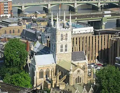 Cathedral Church of St Saviour and St Mary Overie (Southwark Cathedral) |
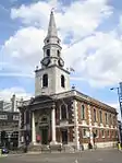
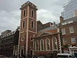
| Church of St Peter | Liverpool Grove, Walworth, Southwark | Church | 1823–1825 | 2 March 1950 | TQ3253178127 51°29′12″N 0°05′33″W |
1385662 | |
| The George Inn | 77 Borough High Street, Southwark | Coaching Inn | 16th century | 2 March 1950 | TQ3266180089 51°30′15″N 0°05′24″W |
1378357 | |
| Tower Bridge (that Part That Lies Within the Borough of Southwark) | Bermondsey, Southwark | Suspension Bridge | 1886–1894 | 6 December 1949 | TQ3364580196 51°30′18″N 0°04′33″W |
1385980 | 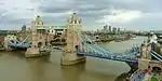 Tower Bridge (that Part That Lies Within the Borough of Southwark) |

Grade II*
| Name | Location | Type | Completed [note 1] | Date designated | Grid ref.[note 2] Geo-coordinates |
Entry number [note 3] | Image |
|---|---|---|---|---|---|---|---|
| Bell House | College Road, Dulwich, Southwark | House | 1767 | 30 June 1954 | TQ3321273470 51°26′40″N 0°05′04″W |
1385409 | |
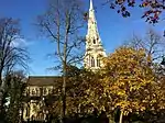
| Church of St Augustine | Lynton Road, Southwark | Church | 1875–1878 | 27 September 1972 | TQ3453578487 51°29′22″N 0°03′49″W |
1385687 |  Church of St Augustine |
| Church of St George the Martyr | Borough High Street, Southwark | Gate Pier | 1734–1736 | 2 March 1950 | TQ3249179763 51°30′05″N 0°05′33″W |
1378366 | |
| Church of St Giles | Camberwell, Southwark | Church | 1842–1844 | 30 June 1954 | TQ3296576633 51°28′23″N 0°05′13″W |
1378398 | |
| Church of St James | Thurland Road, Southwark | Church | 1827–1829 | 6 December 1949 | TQ3429379336 51°29′49″N 0°04′00″W |
1385962 | |
| Church of St Mary Magdalene | Bermondsey Street, Southwark | Church | 15th century | 6 December 1949 | TQ3331179459 51°29′54″N 0°04′51″W |
1376567 | |
| Church of St Mary Rotherhithe | St Marychurch Street, Southwark | Church | Medieval | 6 December 1949 | TQ3517279848 51°30′05″N 0°03′14″W |
1385867 | 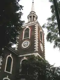 Church of St Mary Rotherhithe |
| Church of St Paul | Herne Hill, Southwark | Church | 1843–1844 | 30 June 1954 | TQ3216074583 51°27′17″N 0°05′57″W |
1385599 |  Church of St Paul |
| Dulwich College, Main Building | Dulwich, Southwark | School | 1866–1870 | 27 September 1972 | TQ3319673006 51°26′25″N 0°05′06″W |
1385418 |  Dulwich College, Main Building |
| Dulwich Picture Gallery and Mausoleum | Dulwich, Southwark | Art Gallery | Late 19th century | 30 June 1954 | TQ3308473628 51°26′46″N 0°05′11″W |
1385543 | |
| Guy's Hospital main building including wings and chapel | Borough, Southwark | Hospital | 1774–1777 | 27 September 1972 | TQ3279380084 51°30′15″N 0°05′17″W |
1385877 | 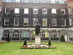 Guy's Hospital main building including wings and chapel |
| Half Moon public house | Half Moon Lane, Herne Hill | Public House | 1896 | 17 September 1998 | TQ3207474332 51°27′09″N 0°06′02″W |
1385592 | .jpg.webp) Half Moon public house |
| Hopton's Almshouses, Hopton Gardens | 10–11 Hopton Gardens, Southwark | Meeting Hall | 1746–1759 | 2 March 1950 | TQ3185480349 51°30′24″N 0°06′05″W |
1385622 | 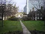 Hopton's Almshouses, Hopton Gardens |
| Hoptons Almshouses, Hopton Gardens | 1–9 Hopton Street, Southwark | Almshouse | 1746–1749 | 2 March 1950 | TQ3183080362 51°30′25″N 0°06′07″W |
1385621 | Hoptons Almshouses, Hopton Gardens |
| Hoptons Almshouses, Hopton Gardens | 12–21 Hopton Street, Southwark | Almshouse | 1746–1749 | 2 March 1950 | TQ3183280330 51°30′24″N 0°06′07″W |
1385623 | .jpg.webp) Hoptons Almshouses, Hopton Gardens |
| Mary Sheridan House (part) and Area Railings | 11–13 St thomas Street, Borough, Southwark | Terraced House | Early 18th century | 6 December 1949 | TQ3279780177 51°30′18″N 0°05′17″W |
1385874 | 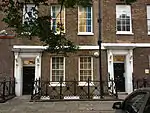 Mary Sheridan House (part) and Area Railings |
| Nelson House Including Railings to Steps | 265 Rotherhithe Street, Southwark | House | c. 1740 | 6 December 1949 | TQ3655880223 51°30′16″N 0°02′02″W |
1385837 | .jpg.webp) Nelson House Including Railings to Steps |
| Number 142 and Attached Railings | 142 Long lane, Southwark | House | c. 1732 | 6 December 1949 | TQ3287779589 51°29′59″N 0°05′13″W |
1385666 |  Number 142 and Attached Railings |
| Number 9 and Attached Railings | 9 St Thomas Street, Southwark | Treasurers House | c. 1706 | 6 December 1949 | TQ3278080184 51°30′18″N 0°05′18″W |
1385872 | 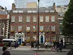 Number 9 and Attached Railings |
| Obelisk at the Centre of St George's Circus | Elephant and Castle, Southwark | Obelisk | 1771 | 2 March 1950 | TQ3165179453 51°29′55″N 0°06′17″W |
1385642 | 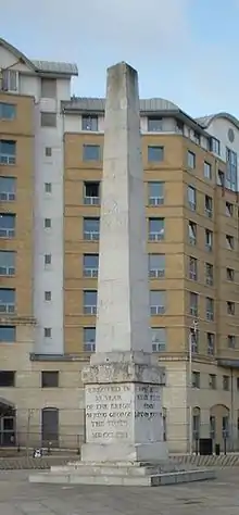 Obelisk at the Centre of St George's Circus |
| Remains of Winchester Palace | Borough, Southwark | Bishops Palace | Early 14th century | 2 March 1950 | TQ3257280391 51°30′25″N 0°05′28″W |
1378484 | 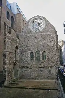 Remains of Winchester Palace |
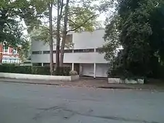
| Six Pillars | Crescent Wood Road, Sydenham, SE26 | House | 1935 | 16 January 1981 | TQ3408972226 51°25′59″N 0°04′21″W |
1385456 | |
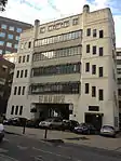
| Southwark Adult Education Institute | formerly Pioneer Health Centre, St Mary's Road, Peckham, Southwark | Further Education College | 1972 | 27 September 1972 | TQ3527676588 51°28′20″N 0°03′13″W |
1385863 |  Southwark Adult Education Institute |
| St Olaf House | London Bridge, Southwark | Sculpture | 1931 | 13 May 1971 | TQ3290380352 51°30′23″N 0°05′11″W |
1385977 | |
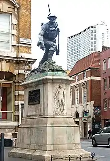
| St Saviour's War Memorial | High Street, Southwark | War memorial | 1922 | 23 March 2018 | TQ3259680097 51°30′15″N 0°05′27″W |
1378368 | |
| Thames Tunnel (that Part which lies in London Borough of Southwark) | Southwark | Tunnel | 1825–43 | 24 March 1995 | TQ3518479963 51°30′09″N 0°03′13″W |
1378391 | 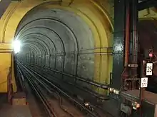 Thames Tunnel (that Part which lies in London Borough of Southwark) |
| 67 Grange Walk | 67 Grange Walk, Bermondsey, Southwark | House | Early 18th century | 27 September 1972 | TQ3345279267 51°29′48″N 0°04′44″W |
1385574 | .jpg.webp) 67 Grange Walk |
| 9a St Thomas Street | 9A St Thomas Street, Borough, Southwark | Museum | 1901 | 6 December 1949 | TQ3276380190 51°30′18″N 0°05′19″W |
1385873 |
.jpg.webp)
.jpg.webp)


Notes
- The date given is the date used by Historic England as significant for the initial building or that of an important part in the structure's description.
- Sometimes known as OSGB36, the grid reference is based on the British national grid reference system used by the Ordnance Survey.
- The "List Entry Number" is a unique number assigned to each listed building and scheduled monument by Historic England.
External links
 Media related to Grade I listed buildings in the London Borough of Southwark at Wikimedia Commons
- Media related to Grade II* listed buildings in the London Borough of Southwark at Wikimedia Commons
This article is issued from Wikipedia. The text is licensed under Creative Commons - Attribution - Sharealike. Additional terms may apply for the media files.