Herne Hill
Herne Hill /hɜːrn/ is a district in South London, England, approximately four miles from Charing Cross and bordered by Brixton, Denmark Hill, Dulwich Village, Loughborough Junction and Tulse Hill. It overlaps the boundary between the boroughs of Lambeth and Southwark. There is a road of the same name in the area (which is part of the A215 and was formerly called Herne Hill Road), as well as a railway station.
Toponymy
In Rocque's 1746 map, the area is shown as "Island Green", probably reflecting the presence of the River Effra and smaller tributaries.[1] Early references to the area also use the form "Ireland Green".
The earliest documented reference to "Herne Hill" is in two fire insurance policies issued by the Sun Insurance Company in 1792 (where the spelling is "Hearns" and "Herns" Hill).[2][3]
History


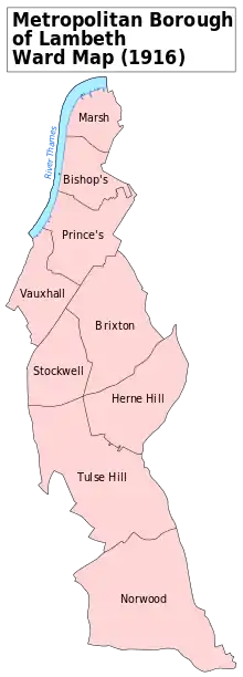
The area now known as Herne Hill was part of the Manor of Milkwell, which existed from at least 1291, and was a mixture of farms and woodland until the late 18th century.[4] It was divided between the ancient parishes of Camberwell and Lambeth.[5] In 1783, Samuel Sanders (a timber merchant) bought the land now occupied by Denmark Hill and Herne Hill from the Manor; he then began granting leases for large plots of land to wealthy families.[6]
By the mid-19th century, the road from the modern Herne Hill Junction to Denmark Hill was lined with large residential estates and the area had become a prosperous suburb for the merchant class. (John Ruskin grew up, from the age of 4, in a house on Herne Hill).[7]

Herne Hill was transformed by the arrival of the London, Chatham & Dover Railway in 1862. Cheap and convenient access to London Victoria, the City of London, Kent and south-west London created demand for middle-class housing; the terraced streets that now characterise the area were constructed in the decades after the opening of Herne Hill station and the old estates were entirely built over.[7]
A letter reporting a Herne Hill sighting of Victorian folklore demon Spring-heeled Jack, "that malapropre fellow of the ghost", was published in the Camberwell and Peckham Times on 9 November 1872. The incident was recorded as taking place where the footpath on Herne Hill ran past St.Paul's Church into Half Moon Lane.[8]
The Half Moon is a Grade II* listed public house in Half Moon Lane.[9]
Herne Hill escaped lightly from V-weapons attacks during World War II, with five V-1 flying bombs and six deaths recorded.[10]
During the early morning of 7 August 2013, an 88‑year‑old 0.9 m diameter water main on Half Moon Lane burst, flooding Herne Hill, Dulwich Road and Norwood Road along with 36 properties (including the Half Moon public house) to create a scene described as "biblical" by local residents.[11] Thames Water admitted liability and estimated the total cost of the damage to be around £4 million.[12] The Half Moon reopened in March 2017, following a vigorous local campaign to save it as a pub; Southwark Council has designated it an asset of community value.[13][14]
Geography

Herne Hill is situated between Brixton, Dulwich Village and Camberwell. It also straddles two boroughs, and is a community of around 15,000 people,[15] with a range of independent shops, art galleries, bars and restaurants. The Southwark half of Herne Hill is part of what is now called the 'North Dulwich Triangle' by estate agents. Famous Herne Hill residents from history include John Ruskin and the Lupino family, and actor Roddy McDowall was born there.
Local landmarks
The area is home to the 50.8 ha (125.5 acres) Brockwell Park. Near a hilltop in Brockwell Park stands the Grade II* listed Brockwell Hall,[16] which was built in 1831. The hall and the land surrounding it were opened to the public in 1891 after being purchased by London County Council. Brockwell Park hosts the annual Lambeth Country Show and was the site of London's Gay Pride festival for several years in the 1990s. The park also houses Brockwell Lido, a 1937 open-air swimming-pool that faces on to Dulwich Road.
Herne Hill railway station on Railton Road was opened by the London, Chatham and Dover Railway in 1862; the Gothic, polychrome brick[17] station building was Grade II listed in 1998.[18] The associated railway viaduct and bridges are also noteworthy; The Building News stated in 1863 that the viaduct was "one of the most ornamental pieces of work we have ever seen attempted on a railway" for its fine brickwork.[19]
The Herne Hill Velodrome, situated in a park off Burbage Road, was built in 1891 and hosted the track cycling events in the 1948 Summer Olympics. Unlike most modern, steeply-banked velodromes, it is a shallow concrete bowl; the 'Save the Herne Hill Velodrome' campaign is seeking a way to secure the future of the site.[20] The same park also has a football pitch and was the home of Crystal Palace F.C. from 1915 until 1918.
A Blue Plaque at 84 Burbage Road marks the former home of the athletics coach Sam Mussabini. Mussabini was later immortalised in the film Chariots of Fire, in which he was played by actor Ian Holm. In 1894, Mussabini was appointed coach to the Dunlop cycling team which trained at the Herne Hill Velodrome. In 1913, Mussabini was appointed coach to the Polytechnic Harriers at the Herne Hill athletics track, which ran round the inside of the Velodrome cycle track. Here he trained athletes, including the fourteen-year-old Harold Abrahams.
In recognition of the historical importance and specialist character of the area within its urban context, Stradella Road was designated as a Conservation Area, by Southwark Council in 2000, under the Civic Amenities Act of 1967. The Conservation Area consists principally of properties in Stradella and Winterbrook Roads, and includes bordering properties in Burbage Road and Half Moon Lane.[21]
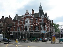
The Half Moon Public House on Half Moon Lane was built in 1896 (although a tavern has existed on the site since the 17th century) and was Grade II* listed in 1998.[22] The pub hosted a boxing gym for more than 50 years.[23] The Commercial on Railton Road was rebuilt in 1938, and is locally listed by Lambeth Council as an inter-war pub of architectural and historic interest.[24]
The Church of St Paul on Herne Hill was originally built by G Alexander in 1843 at a cost of £4,958,[25] but dramatically rebuilt by Gothic architect G E Street in 1858 after a destructive fire. It is now Grade II* listed.[26]
The lake in Sunray Gardens (at the junction of Elmwood Road and Red Post Hill) was originally the fish pond in Casino House (a large estate established in 1796/97, now demolished); the adjoining Casino Estate still bears the house's name.
Delawyk Crescent is a housing estate with an unusual Radburn layout, separating vehicle and pedestrian movements. It was built in the 1960s and 1970s built on land from the Dulwich Estate.[27]
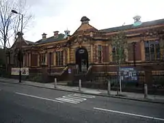
The Carnegie Public Library on the road now named Herne Hill Road opened in 1906 after a Lambeth librarian got a grant from Andrew Carnegie for building a library within the Herne Hill area. It is also a listed Grade II building.[28]
A Blue Plaque at 51 Herne Hill (by the junction with Danecroft Road) marks the former home of author Sax Rohmer (a.k.a. Arthur Henry Ward), most famous as author of the series of novels featuring the master criminal Dr. Fu Manchu.
Notable former and current residents
- George Nicoll Barnes, Labour politician
- Elhanan Bicknell, merchant and art collector
- Sir James Black, Nobel Prize winning pharmacologist[29]
- John Blades, glassware manufacturer, builder of Brockwell Hall
- John Braham, singer
- Horace Brodzky, Australian-born artist and writer
- Anita Brookner, novelist, winner of the Man Booker Prize
- Richard Church, writer and poet
- Judah Cohen, merchant and slave-owner
- Olivia Colman, actress
- Michael Crawford, actor, singer, comedian
- Huw Edwards, broadcaster
- Henry Havelock Ellis, writer
- Hans Eysenck, psychologist
- Joel Fry, actor
- Andy Hamilton, comedian
- Harriet Harman, MP for Camberwell and Peckham
- Robert Hunt, Assistant Commissioner (Metropolitan Police)
- Ernie Izzard, British lightweight champion boxer, nicknamed "The Herne Hill Hairpin"
- Elly Jackson, lead singer of La Roux
- C.L.R. James, writer and political philosopher
- Reginald Victor Jones, physicist and Scientific Intelligence Expert
- Marie Loftus, music hall artiste
- Cecilia Loftus, actress
- Ida Lupino, actress and director
- Roddy McDowall, actor
- Eric Mottram, central figure in the British Poetry Revival
- James Nesbitt, actor
- Sam Mussabini, athletics coach
- Jay Rayner, food critic
- Lillian Rich, film actress
- George Robey, English music hall comedian and singer
- Sax Rohmer, Creator of Fu Manchu
- John Ruskin, art critic and social thinker
- Mark Rylance, actor
- Ed Simons, one half of The Chemical Brothers
- Micky Stewart, England and Surrey cricketer
- Anna Storace, singer
- Bert Temple, founder of the Ancient Order of Froth Blowers
- Steve Waller, musician
- Jessie Ware, singer[30]
- Mortimer Wheeler, archaeologist
- Yungen, rapper
- Adrian Thrills, music journalist
- Sinan Savaskan, composer and educator
Transport
Rail
Direct rail services are available from Herne Hill railway station to London Blackfriars, Farringdon, St. Pancras International, Luton Airport and London Victoria.
Nearby railway stations offer services to other destinations: London Bridge station can be reached from North Dulwich; since December 2012 Denmark Hill has trains to Clapham Junction in south-west London and Highbury and Islington in north-east London via the London Overground's South London Line. The nearest London Underground station is Brixton on the Victoria line. There have been past proposals to extend the Victoria line to Herne Hill station on a large reversing loop.[31]
References
- The Story of Norwood J.B. Wilson & H.A. Wilson ISBN 978-0951538418
- See article by B. Nurse, Herne Hill Society Magazine, Summer 2016, https://issuu.com/hernehillsociety/docs/herne-hill-mag-135. The earliest recorded reference on a map is in James Edwards, A Companion from London to Brighthelmston, in Sussex: Consisting of a Set of Topographical Maps from Actual Surveys. Edwards' Companion was published in complete form in 1801, but the relevant map has the publication date 1 March 1800. The map uses the spelling "Hearn". The descriptive text, which does not mention Herne Hill, refers to the survey being under way in 1789. The name therefore appeared at some point between then and 1800, prompted by the need to find a description for the location of the newly built houses, though it is likely it must have been in use orally long before then. This is consistent with the evidence of the fire insurance policies and a small sketch by Thomas Girtin (1705–1802), inscribed “Herne Hill” and not dated, but attributed to 1796/7 in D. Girtin and D. Loshak , The Art of Thomas Girtin (London, 1974), the sketch appearing to show a small group of buildings on sloping ground with building materials in the foreground (sketch in the Huntingdon Library, California, object no. 59.55.596).
- Herne Hill Society, Herne Hill Heritage Trail (rev. edn, 2013); J. Brunton, A Short History of Herne Hill (Herne Hill Society, 2011). See also A Dictionary of London Place-Names, A. D. Mills, OUP Oxford, 2010, ISBN 9780199566785, probably named from a field called “le Herne” (c.1495), that is "the angle or corner of land" from Anglo Saxon hyrne (cognate with the English word "horn"), with the later addition of “hill”. Alternatively, it may take its name from the family called Herne mentioned in connection with nearby Dulwich from the 17th century (although their surname almost certainly derives from the same, or a similar, early place name). A link to “heron” has also been suggested, the river Effra being once frequented by herons.
- British History Online - Myatt's Fields, Denmark Hill and Herne Hill
- "Parishes: Camberwell", British History Online.
- Survey of London: volume 26: Lambeth: Southern area, British History Online.
- "Myatt's Fields, Denmark Hill and Herne Hill", British History Online.
- Matthews, John (2016). The Mystery of Spring-Heeled Jack: From Victorian Legend to Steampunk Hero. Simon & Schuster. ISBN 1620554976.
- Historic England. "Half Moon public house (1385592)". National Heritage List for England. Retrieved 18 April 2014.
- "V1 & V2 logs SE24 Herne Hill". Retrieved 19 June 2016.
- "Herne Hill properties flooded after burst water main". BBC News Online. 7 August 2013. Retrieved 8 November 2013.
- Prynn, Jonathan (9 August 2013). "Thames Water's £4m bill for Herne Hill flood after burst water main". London Evening Standard. Retrieved 8 November 2013.
- Mike Urban, "Campaign to save the Herne Hill’s Half Moon pub gathers momentum with an ACV application", Brixton Buzz, 27 November 2015.
- "Latest on The Half Moon", Herne Hill Society.
- "Herne Hill". lambeth.gov. Retrieved 10 February 2018.
- Historic England. "BROCKWELL HALL (1080511)". National Heritage List for England. Retrieved 28 April 2012.
- Cherry, Bridget; Pevsner, Nikolaus (1983). Buildings of England, London: South, Volume 2. London: Penguin. p. 363.
- Historic England. "HERNE HILL RAILWAY STATION, ENTRANCE BLOCK ONLY (1376144)". National Heritage List for England. Retrieved 20 April 2012.
- "London, Chatham and Dover Railway". The Building News. The Proprietor of the "Building News". 10 (9 January): 27. 1863.
- Save the Herne Hill Velodrome. Retrieved 28 April 2012
- "Stradella Road - Conservation Area Appraisal" (PDF). southwark.gov. Southwark Council. Retrieved 20 May 2018.
- Historic England. "HALF MOON PUBLIC HOUSE (1385592)". National Heritage List for England. Retrieved 28 April 2012.
- "Where the pugilists drink", Times Online. Retrieved 28 April 2012.
- "List of heritage assets of Local Architectural or Historic Interest (Local List)" (PDF). Lambeth Council. Retrieved 25 February 2018.
- Calne - Cambourne, British History Online.
- Historic England. "CHURCH OF ST PAUL, HERNE HILL (1385599)". National Heritage List for England. Retrieved 28 April 2012.
- Delawyk Residents Management Organisation http://www.delawyk.org/about.html
- Myatt's Fields, Denmark Hill and Herne Hill. British History Online.
- "Sir James Black: Blue Plaque application for JKPS building". Judith Kerr Primary School. Retrieved 1 November 2016.
- Manning, James. "Jessie Ware interview: 'My sound man tells me to shut up'". Time Out London. Retrieved 17 September 2017.
- "Archived copy". Archived from the original on 16 August 2013. Retrieved 29 August 2013.CS1 maint: archived copy as title (link) (Click on the arrow pointing south east from Brixton and then, on the popup, click on "more")
- Buses from Herne Hill (PDF). Transport for London. 2011. Retrieved 20 April 2012.
External links
| Wikimedia Commons has media related to London SE24. |
| Wikimedia Commons has media related to Herne Hill. |


