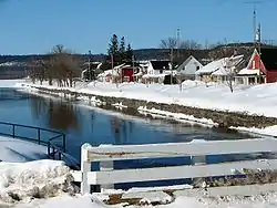
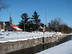
Grenville, Quebec
Grenville is a village municipality in the Argenteuil Regional County Municipality of the Laurentides region of Quebec, Canada. It is located opposite Hawkesbury, Ontario, on the Ottawa River.
Grenville | |
|---|---|
 | |
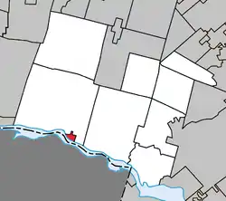 Location within Argenteuil RCM. | |
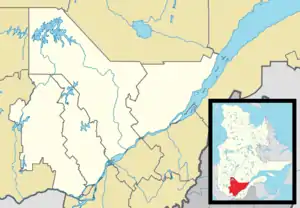 Grenville Location in central Quebec. | |
| Coordinates: 45°38′N 74°36′W[1] | |
| Country | |
| Province | |
| Region | Laurentides |
| RCM | Argenteuil |
| Settled | 1810 |
| Constituted | January 1, 1876 |
| Government | |
| • Mayor | Luc Grondin |
| • Federal riding | Argenteuil—La Petite-Nation |
| • Prov. riding | Argenteuil |
| Area | |
| • Total | 5.30 km2 (2.05 sq mi) |
| • Land | 2.81 km2 (1.08 sq mi) |
| Population (2011)[3] | |
| • Total | 1,577 |
| • Density | 560.4/km2 (1,451/sq mi) |
| • Pop 2006-2011 | |
| • Dwellings | 738 |
| Time zone | UTC−5 (EST) |
| • Summer (DST) | UTC−4 (EDT) |
| Postal code(s) | J0V 1J0 |
| Area code(s) | 819 |
| Highways | |
| Census profile | 2476055[3] |
| MAMROT info | 76055[2] |
| Toponymie info | 26968[1] |
| Website | www |
History
Although Grenville was already shown on the Gale and Duberger Map of 1795, it was not until January 28, 1808, that Grenville Township was officially established; the township's name commemorated Lord George Grenville. Two years later, in 1810, the first French and English settlers arrived in the area.[4][5]
Its strategic location on the Ottawa River and the construction of the Carillon Canal in 1819 led to the town's real growth.[6] In 1826 the first general store opened and in 1828, the first school. In 1830 "Kingsey" sawmill was built, and a flour mill was added in 1838. In 1857 construction began on the Carillon and Grenville Railway, which was completed six years later.[5]
In 1861 the village and its surroundings had about 900 inhabitants. On January 1, 1876, the Village Municipality of Grenville was formed at which time it exceeded one thousand persons.[6]
In 1910 the Carillon and Grenville Railway was abandoned and later on dismantled.[5]
Grenville Canal
The Grenville Canal, the Chute-à-Blondeau Canal, and the Carillon Canal were built to navigate the Long Sault Rapids on the Ottawa River which stretched for 21 kilometers (13 mi) from Carillon to Grenville. The impetus for these canals was the War of 1812. During this war, attacks along the Saint Lawrence River jeopardized the communication lines between Kingston and Montreal, the two main military positions of Upper and Lower Canada. The Ottawa River Canal and the Rideau Canal were thus designed as an alternative military supply route in the event of war with the Americans.[7][8]
Work on the canal began in 1818 with the construction of a storage warehouse. In 1819 Captain Henry Vernet of the Royal Engineers arrived from Britain to lead the construction of the project. Hundreds of Irish immigrants and French Canadians were used to excavate the canal under the direction of a hundred British soldiers. In 1833 the Grenville Canal was completed with an original length of 9.5 kilometers (5.9 mi) and the entire network on the Ottawa River, including the 11 locks, was not fully completed until about 1843.[9]
The military requirements decided all aspects of the canal. The size of the locks were set to 134 feet (41 m) long, 33 feet (10 m) wide, and only 5 feet (1.5 m) deep at the thresholds. These dimensions, standards adopted for military use, were insufficient for any commercial use.[9] Forestry had become the main economic activity in this region, and from 1867, local business people demanded that the government carry out improvements to the network because the original canal network had become outdated. In 1870 the Canals Commission recommended making the Ottawa River deeper between Lachine and Ottawa. Therefore, between 1873 and 1882, the Grenville and Carillon Canals were enlarged (the dam built upstream from the village of Carillon raised the level of the Ottawa River at Chute-à-Blondeau, making the need for a lock there no longer necessary).[7]
Further changes were made from 1959 to 1963 with the construction of the Carillon hydroelectric dam and a modern 20 meters (66 ft) high lock at Carillon. This work substantially and irreversibly changed the canal network. The dam raised the water level by over 62 feet (19 m) at Carillon and over 9 feet (2.7 m) at Grenville. The new water level flooded Greece's Point and its surroundings several feet underwater and inundated the rapids of Long-Sault, transforming them into calm water.[9] Shortly afterwards, the steel swing bridge and canal locks were dismantled.[5]
Demographics
Population:[10]
- Population in 2011: 1577
- Population in 2006: 1398
- Population in 2001: 1315
- Population in 1996: 1443
- Population in 1991: 1362
Private dwellings occupied by usual residents: 666 (total dwellings: 738)
Mother tongue:[11]
- English as first language: 9%
- French as first language: 88%
- English and French as first language: 2%
- Other as first language: 1%
Education
The Commission scolaire de la Rivière-du-Nord operates French-language public schools.[12]
- École Dansereau/Saint-Martin
- École polyvalente Lavigne in Lachute
The Sir Wilfrid Laurier School Board operates the English-language public schools.
- Grenville Elementary School[13]
- Laurentian Regional High School in Lachute[14]
Notable people
- Marcel Desjardins (1941–2003), journalist, news editor and director[15]
References
- Reference number 26968 of the Commission de toponymie du Québec (in French)
- Geographic code 76055 in the official Répertoire des municipalités (in French)
- "(Code 2476055) Census Profile". 2011 census. Statistics Canada. 2012.
- "Grenville (Canton)" (in French). Commission de toponymie du Québec. Retrieved 2009-02-09.
- "Historique" (in French). Village de Grenville. Retrieved 2009-02-09.
- "Grenville (Municipalité de village)" (in French). Commission de toponymie du Québec. Retrieved 2009-02-09.
- "Carillon Canal National Historic Site of Canada, Cultural Heritage". Parks Canada. Archived from the original on 2007-05-06. Retrieved 2009-02-09.
- "Canal" (in French). Village de Grenville. Retrieved 2009-02-09.
"La construction du canal était la conséquence des conflits militaires de 1812. Ce canal devait constituer avec son réseau de canalisation, en temps de guerre, une voie d’approvisionnement militaire vers Kingston et les Grands Lacs."
English: "The construction of the [Grenville] canal was a consequence of the military conflicts in 1812. This canal was to constitute, along with a network of other canals, a military supply route towards Kingston and the Great Lakes during wartime." - "Canal" (in French). Village de Grenville. Retrieved 2009-02-09.
- Statistics Canada: 1996, 2001, 2006, 2011 census
- "(Code 2476055) Community Profiles". 2006 census. Statistics Canada. 2007.
- "Trouver une école ou un centre." Commission scolaire de la Rivière-du-Nord. Retrieved on September 24, 2017. For attendance boundary information, click "Par bassin d'école"
- "Home." Grenville Elementary School. Retrieved on September 16, 2017.
- "LAURENTIAN REGIONAL HS ZONE." Sir Wilfrid Laurier School Board. Retrieved on September 4, 2017.
- Hustak, Alan (11 February 2003). "Assistant publisher at La Presse leaves a great void". The Gazette. Montreal, Quebec. p. 6.

External links
 Media related to Grenville, Quebec at Wikimedia Commons
Adjacent Municipal Subdivisions | |
|---|---|
| Towns | |
|---|---|
| Municipalities | |
| Townships | |
| Villages | |
| |