Guelmim-Es Semara
Guelmim-Es Semara (Arabic: كلميم السمارة) was one of the sixteen former regions of Morocco from 1997 to 2015. It covered an area of 122,825 km² and had a population of 501,921 (2014 census).[1] The regional capital was Guelmim.
Guelmim-Es Semara
كلميم السمارة | |
|---|---|
.svg.png.webp) Location in Morocco | |
| Coordinates: 28°09′N 10°04′W | |
| Country | |
| Created | 1997 |
| Abolished | September 2015 |
| Capital | Guelmim |
| Area | |
| • Total | 122,825 km2 (47,423 sq mi) |
| Population (2014 census) | |
| • Total | 501,921 |
| Time zone | UTC+0 (WET) |
| • Summer (DST) | UTC+1 (WEST) |
Geography
The southern half of Guelmin-Es Semara formed part of the Western Sahara. The region was bordered to the north by Souss-Massa-Drâa and to the west by Laayoune-Boujdour-Sakia El Hamra, with the Algerian province of Tindouf to the east. Its disputed territory in the Western Sahara bordered the Mauritanian Tiris Zemmour Region. Guelmin-Es Semara had a coastline on the Atlantic Ocean, with the Spanish Canary Islands lying off it. The Draa River, at 1,100 km the longest in Morocco, flowed through the region into the Atlantic Ocean near Tan-Tan.
The region was made up of the following provinces:
Municipalities by population (2004 census)[2]
- Guelmin, Guelmim Province: 95,599
- Tan-Tan, Tan-Tan Province: 60,560
- Es Semara, Es Smara Province: 33,910[3]
- Tata, Tata Province: 15,192
- Bouizakarne, Guelmim Province: 11,982
- Assa, Assa-Zag Province: 11,667
- Foum Zguid, Tata Province: 9,611
- Zag, Assa-Zag Province: 7,751
- El Ouatia, Tan-Tan Province: 6,294
- Akka, Tata Province: 6,312
- Fam El Hisn, Tata Province: 6,183
References
- "Recensement général de la population et de l'habitat de 2004" (PDF). Haut-commissariat au Plan, Lavieeco.com. Retrieved 22 April 2012.
- Maaroufi, Youssef. "Recensement général de la population et de l'habitat 2004".
- Within the Western Sahara
Capital: Guelmim | ||
| Provinces | 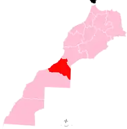 | |
| Cities | ||
| from 2015 | ||
|---|---|---|
| 1997–2015 |
| |
| 1971–1997 |
| |
Regions falling partly (*) or entirely (**) within the disputed territory of Western Sahara | ||