Guiuan
Guiuan ([ˈgiˌwan] ![]() (listen); Waray: Bungto han Guiuan, Filipino: Bayan ng Guiuan), officially the Municipality of Guiuan, is a 2nd class municipality in the province of Eastern Samar, Philippines. According to the 2015 census, it has a population of 52,991 people. [3]
(listen); Waray: Bungto han Guiuan, Filipino: Bayan ng Guiuan), officially the Municipality of Guiuan, is a 2nd class municipality in the province of Eastern Samar, Philippines. According to the 2015 census, it has a population of 52,991 people. [3]
Guiuan | |
|---|---|
| Municipality of Guiuan | |
 Municipal Hall | |
| Etymology: Tenigbang (Waray-waray for "partly chiseled off") | |
| Motto(s): Sulong pa, Guiuan! (Waray-waray for "Advance, Guiuan!"); Guiuan, Bungto ta, Higugma-a ta. (Waray-waray for "Let us Love our Town, Guiuan.") | |
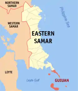 Map of Eastern Samar with Guiuan highlighted | |
.svg.png.webp) Guiuan Location within the Philippines | |
| Coordinates: 11°02′N 125°44′E | |
| Country | |
| Region | Eastern Visayas (Region VIII) |
| Province | Eastern Samar |
| District | Lone District |
| Barangays | 60 (see Barangays) |
| Government | |
| • Type | Sangguniang Bayan |
| • Mayor | Annaliza G. Kwan |
| • Vice Mayor | Veronica C. Ramirez |
| • Representative | Maria Fe R. Abunda |
| • Councilors | List
|
| • Electorate | 35,670 voters (2019) |
| Area | |
| • Total | 175.49 km2 (67.76 sq mi) |
| Elevation | 8.0 m (26.2 ft) |
| Population | |
| • Total | 52,991 |
| • Density | 300/km2 (780/sq mi) |
| • Households | 12,394 |
| Demonym(s) | Guiuananon |
| Economy | |
| • Income class | 2nd municipal income class |
| • Poverty incidence | 34.59% (2015)[4] |
| • Revenue | ₱123,167,904.38 (2016) |
| Time zone | UTC+8 (PST) |
| ZIP code | 6809 |
| PSGC | |
| IDD : area code | +63 (0)55 |
| Climate type | tropical rainforest climate |
| Native languages | Waray Tagalog |
| Website | www |
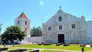
Guiuan played a significant part in Philippine history. In the 16th century, when Ferdinand Magellan discovered the Philippines, it is believed that he first landed on the island of Homonhon, which lies within the municipality. It is probably because of this that the majority of the population of the town are Catholics. The town's church, the Church of the Immaculate Conception, is one of the oldest in the country.
During the Second World War, Guiuan served as one of the naval bases for the Allies. Now all that is left of the American occupation are concrete slabs which once served as the foundations of a vast supply depot, and an air strip, which now serves as the town's own airport.
As well as a rich historical background, Guiuan has many scenic spots. Being a coastal town on the Pacific side, the town has many white-sand beaches that are suitable for swimming and surfing.
The Guiuan Church is currently in the tentative list for UNESCO World Heritage Sites under the Baroque Churches of the Philippines (Extension). A proposal has been suggested by scholars to make a separate UNESCO inclusion for the Old Centre of Guiuan which includes the Guiuan Church. The same would be made for other churches listed in UNESCO's tentative sites, where each town plaza and surrounding heritage buildings would be added. No government agency has yet to take action on the proposal.
In 8 November 2013, it was the first town in the Philippines that was hit by Typhoon Haiyan (Super Typhoon Yolanda).
History
Guiuan is widely known for two significant events in history 423 years apart. In 1521, Ferdinand Magellan, first European to set foot on Philippine soil, landed in Homonhon, now part of Guiuan. In 1944, the American Forces landed on the island of Suluan where they fought their first battle in the Philippine territory three days before Gen. Mac Arthur stormed the beaches of Leyte.
The name of the town originated from its geographical location. The first settlers named the town Guibang when they discovered a sharp break in the mountain range (Waray: tenigbang, 'partly chiseled off') which screens the town from the Pacific Ocean in the East. Subsequently, settlers modified its name to Guiuan.
The occurrence of World War II shook the town and people moved to the mountains to find comfort. On June 28, 1943, several Japanese soldiers set foot on Guiuan soil. Not as fearful and brutal as they were thought of by the local populace, a cordial relation soon existed between the conquered and the conquerors. Evacuees came down from the mountains and resumed a normal urban life.
Except for a few killings of suspected traitors by both Japanese, Filipino soldiers and local guerillas, not a drop of blood was shed needlessly. This made Guiuan one of the few places in the islands where World War II did not leave so many tragic memories.
The first sign of liberation of the town came on November 27, 1944, when a US Navy submarine chaser steamed the harbor for reconnaissance duty. On December 1, 1944, a fleet of LCTs, Liberty ships and barges poured into the Guiuan Bay to unload machines that was to transform Guiuan into one of the biggest Naval Bases in the Far East that time, set up by the American Navy, part of the Allies.
Now all that is left of the American occupation are concrete slabs which once served as the foundations of a vast supply depot, and an air strip, which now serves as the town's own airport.
In 1949, the International Refugee Organisation made an appeal to tackle the displacement crisis caused by the war and a precursor to the UNHCR. It wanted new homes for thousands of White Russians in the aftermath of the Bolshevik Revolution (Russian Revolutions) and subsequent civil war. More than 5,000 of them, under the care of John Maximovitch (Saint John of Shanghai and San Francisco), the Orthodox Archbishop of Shanghai who would later be canonised, were taken to the island of Tubabao, located a couple of hundred metres from the coast of Guiuan.[5]
In 1952, the sitios of Talisay, Bagambang, Calamrisan, Lo-ok and Barawalti, belonging to Barrio Tubabao, were separated and created into the barrio of Trinidad.[6]
On November 10, 1978, Proclamation No. 1801 was issued declaring Guiuan as a Tourist Zone and Marine Reserve under the administration and control of the Philippine Tourism Authority (PTA).
On November 8, 2013, the city suffered heavy damage, along with 107 fatalities, 16 missing and over 3,626 injuries, as it was hit by the eye of Typhoon Haiyan (Super Typhoon Yolanda) with maximum ten-minute sustained wind speeds of 230 km/h (145 mph). Haiyan made its first landfall over Guiuan at 04:40 PhST.[7]
Almost every building was heavily damaged or deroofed, including the designated typhoon shelters, the Catholic Church, hospital and gymnasium. However, one house in Lactason remained intact because of the owner's effort to hold it in place with her bare hands. The woman was later identified as Mana Maring, a moron (a Filipino delicacy) maker and vendor.
Geography
The municipality of Guiuan is located at the southeasternmost tip of Samar Island. It is bounded on the north by the municipality of Mercedes, on the east by the Philippine Sea and the Pacific Ocean, on the south by the Surigao Strait, and on the west by the Leyte Gulf.
Clustered around the municipality are numerous islands and islets such as Manicani, Calicoan, Sulangan, Candulo, Homonhon, Suluan and Tubabao. They are protected as part of the marine reserve known as the Guiuan Protected Landscape and Seascape.
Guiuan is 109 kilometres (68 mi) south of Borongan and 154 kilometres (96 mi) from Tacloban. It has a total land area of 175.49 square kilometres. It is composed of sixty (60) barangays and the only town in the province with biggest number of island barangays.
Barangays
Guiuan is politically subdivided into 60 barangays,[8] 37 of which is located in the mainland of Guiuan, i.e. the portion of Guiuan that is contiguous with the Samar Island, and the remaining 23 in the islands surrounding the mainland.
Mainland barangays

Poblacion barangays: The poblacion, or town center, is located on the southwestern coastal area of the Guiuan mainland, facing the Leyte Gulf.
- Poblacion Ward 1
- Poblacion Ward 2
- Poblacion Ward 3
- Poblacion Ward 4
- Poblacion Ward 4-A
- Poblacion Ward 5
- Poblacion Ward 6
- Poblacion Ward 7
- Poblacion Ward 8
- Poblacion Ward 9
- Poblacion Ward 9-A
- Poblacion Ward 10
- Poblacion Ward 11
- Poblacion Ward 12
Other mainland barangays:
- Alingarog
- Bagua
- Banahao
- Barbo
- Bucao
- Bungtod
- Cagdara-o
- Campoyong
- Cantahay
- Cogon
- Dalaragan
- Gahoy
- Hagna
- Hollywood
- Lupok
- Mayana
- Salug
- Santo Niño (or Sto. Niño)
- Sapao
- Surok
- Tagporo
- Taytay
- Timala
Island barangays
.jpg.webp)
Barangays in Calicoan Island and neighboring islets:
- Baras
- Ngolos
- Pagnamitan
- Sulangan
Barangays in Tubabao Island and neighboring islets:
- Camparang
- San Antonio
- San Juan
- San Pedro
- Trinidad
Barangays in Manicani Island:
- Banaag
- Buenavista
- Hamorawon
- San Jose
Barangays in Homonhon Island:
- Bitaugan
- Cagusu-an
- Canawayon
- Casuguran
- Culasi
- Habag
- Inapulangan
- Pagbabangnan
Other island barangays:
- Victory - Victory Group of Islands
- Suluan - Suluan Island
Climate
| Climate data for Guiuan, Eastern Samar (1981–2010, extremes 1973–2012) | |||||||||||||
|---|---|---|---|---|---|---|---|---|---|---|---|---|---|
| Month | Jan | Feb | Mar | Apr | May | Jun | Jul | Aug | Sep | Oct | Nov | Dec | Year |
| Record high °C (°F) | 32.9 (91.2) |
33.8 (92.8) |
34.3 (93.7) |
36.1 (97.0) |
37.6 (99.7) |
37.0 (98.6) |
35.4 (95.7) |
35.0 (95.0) |
35.8 (96.4) |
34.5 (94.1) |
36.0 (96.8) |
33.0 (91.4) |
37.6 (99.7) |
| Average high °C (°F) | 28.4 (83.1) |
28.8 (83.8) |
29.6 (85.3) |
31.0 (87.8) |
32.0 (89.6) |
31.7 (89.1) |
31.0 (87.8) |
31.3 (88.3) |
31.4 (88.5) |
30.7 (87.3) |
29.8 (85.6) |
28.9 (84.0) |
30.4 (86.7) |
| Daily mean °C (°F) | 26.2 (79.2) |
26.5 (79.7) |
27.0 (80.6) |
28.1 (82.6) |
28.8 (83.8) |
28.6 (83.5) |
28.1 (82.6) |
28.3 (82.9) |
28.3 (82.9) |
27.8 (82.0) |
27.2 (81.0) |
26.6 (79.9) |
27.6 (81.7) |
| Average low °C (°F) | 24.0 (75.2) |
24.1 (75.4) |
24.4 (75.9) |
25.2 (77.4) |
25.6 (78.1) |
25.4 (77.7) |
25.1 (77.2) |
25.3 (77.5) |
25.2 (77.4) |
25.0 (77.0) |
24.7 (76.5) |
24.4 (75.9) |
24.9 (76.8) |
| Record low °C (°F) | 19.0 (66.2) |
20.0 (68.0) |
18.0 (64.4) |
19.7 (67.5) |
20.7 (69.3) |
20.3 (68.5) |
18.5 (65.3) |
20.6 (69.1) |
20.0 (68.0) |
20.0 (68.0) |
20.0 (68.0) |
20.0 (68.0) |
18.0 (64.4) |
| Average rainfall mm (inches) | 371.3 (14.62) |
276.7 (10.89) |
218.8 (8.61) |
125.7 (4.95) |
141.2 (5.56) |
185.6 (7.31) |
211.5 (8.33) |
160.6 (6.32) |
177.4 (6.98) |
290.0 (11.42) |
406.7 (16.01) |
440.1 (17.33) |
3,005.6 (118.33) |
| Average rainy days (≥ 0.1 mm) | 23 | 19 | 18 | 16 | 15 | 16 | 16 | 13 | 15 | 19 | 22 | 25 | 217 |
| Average relative humidity (%) | 88 | 86 | 85 | 84 | 84 | 85 | 85 | 85 | 84 | 86 | 88 | 89 | 86 |
| Source: PAGASA[9][10] | |||||||||||||
Demography
|
| ||||||||||||||||||||||||||||||||||||||||||||||||
| Source: Philippine Statistics Authority [3] [11] [12][13] | |||||||||||||||||||||||||||||||||||||||||||||||||
Guiuan recorded a total population of 38,694 in 2000, which rose to 47,037 in 2010 and 52,991 in 2015.[14] It has the second largest population in Eastern Samar (after Borongan) with a population density of 270 persons per km2.
Majority or 97.7% of the Guiuananons speak the Waray-Waray language. Less than 3.0% speak Cebuano (including the Boholano dialect) and Tagalog. A few percentage can converse in English, with varying degrees of proficiency.
Economy
.jpg.webp)
Guiuan is classified as a second income class municipality as of CY 2008. Its Total Financial Resources amounted to 67.71 million pesos. Its Internal Revenue Allotment (IRA) represents 78.0% of its total financial resources.
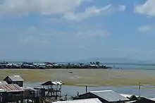
Being a fishing community and the only municipality with the most number of island barangays, the town is rich in fishery and aquatic resources. It is considered by the fisheries authorities as the best fishing belt in the region.
The coastal waters offer almost all species of marine life: euchuema, abalone, ornamental fish, lobster and the golden cowry (known for its extraordinary golden sheen). They also offer delicacies, shellcraft products as well as fresh and processed marine products.
Existing land use indicates a predominance of agriculture which covers 38.2% of the total land area. Most of the agricultural lands are dominantly planted with coconut trees. Other major crops include vegetables, root crops, palay, corn, banana and other fruit trees, coffee and pineapple.
The municipality is likewise rich in mineral resources. It has an estimated mineral reserve of bauxite, nickel and titaferous magnitie of more than 26.7 million metric tons.
Transportation
.jpg.webp)
- By air
Guiuan Airport has a 2,800-metre (9,200-ft) runway which can service light private planes, chartered cargo and military planes. The Guiuan Airport was upgraded in 2010. Cebu-based airline Mid-Sea Express had scheduled flights from Cebu City to Guiuan twice weekly on Saturdays and Mondays, using a 19-seater Jetstream 32 aircraft. Service started in 2012 but has now been discontinued.
- By land
The town is accessible by land with highway connection from Tacloban City, about three-four hours travel. Several buses and vans regularly shuttle passengers to Guiuan. It is also accessible from Borongan City. Alternatively, several bus companies have daily trips to Guiuan from Manila. Travel time is approximately twenty-one hours.
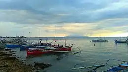
Since the town is a coastal municipality, it has a small seaport operational throughout the year.
Point of Interest
- Sulangan Church
The church is also known as The Shrine of St. Anthony of Padua. It is known to both the locals and pilgrims around Eastern Visayas because of being miraculous. Saint Anthony of Padua is considered the patron saint for lost items, articles, people, or even spiritual goods. Many people visit the church to ask Saint Anthony even the most impossible wishes and the saint is believed to grant them.
- Linao Cave
Linao Cave is one of the most famous attractions in Guiuan because of its crystal clear water. The cave is named linao which means “clear” in Waray.
Utilities

Telephone companies operating in the municipality includes TELECOM, Globelines and Bayantel. Smart and Globe cellular phone companies are also operational. The town also has a local radio station, Radyo Natin Guiuan (103.7 MHz), serving Guiuan and neighboring areas in Eastern Visayas.

In 2004, Eastern Samar Electric Cooperative (ESAMELCO) was able to energize Guiuan, Calicoan Island up to Sulangan covering 37 out of 60 barangays. Island barangays are served with electricity through generator sets either privately owned or operated by the barangay council. However, electricity shortages are frequent and subscribers experience weekly power failures, lasting for 10 to 12 hours or for 24 hours in severe cases.
Guiuan is also the site of one of the weather stations of the Philippine Atmospheric, Geophysical and Astronomical Services Administration, located in Barangay Sapao. Positioned at 60 metres (200 ft) above sea level, the facility consists of a Surface Synoptic Station for usual weather observation and a Doppler weather radar station for detecting intensity (reflectivity) and velocity (by Doppler effect) of distant weather elements. The radar station was built and renovated with the aid of the Japan International Cooperation Agency (JICA).
References
- Municipality of Guiuan | (DILG)
- "Province: Eastern Samar". PSGC Interactive. Quezon City, Philippines: Philippine Statistics Authority. Retrieved 12 November 2016.
- Census of Population (2015). "Region VIII (Eastern Visayas)". Total Population by Province, City, Municipality and Barangay. PSA. Retrieved 20 June 2016.
- "PSA releases the 2015 Municipal and City Level Poverty Estimates". Quezon City, Philippines. Retrieved 12 October 2019.
- "A forgotten episode in Russian history leaves links with the Philippines". INDEPENDENT.co.uk. Retrieved January 13, 2019.
- "An Act Creating the Barrio of Trinidad, Guiuan, Province of Samar". LawPH.com. Retrieved 2011-04-09.
- Final Report RE: Effects of Typhoon "Yolanda" (Haiyan) (PDF) (Report). The Philippine National Disaster Risk Reduction and Management Council. December 11, 2015. Archived (PDF) from the original on May 6, 2016. Retrieved May 6, 2016.
- "Province: Eastern Samar". PSGC Interactive. Makati City, Philippines: National Statistical Coordination Board. Archived from the original on 5 June 2013. Retrieved 24 April 2013.
- "Guiuan, Eastern Samar Climatological Normal Values". Philippine Atmospheric, Geophysical and Astronomical Services Administration. Archived from the original on 14 October 2018. Retrieved 14 October 2018.
- "Guiuan, Eastern Samar Climatological Extremes". Philippine Atmospheric, Geophysical and Astronomical Services Administration. Archived from the original on 14 October 2018. Retrieved 14 October 2018.
- Census of Population and Housing (2010). "Region VIII (Eastern Visayas)". Total Population by Province, City, Municipality and Barangay. NSO. Retrieved 29 June 2016.
- Censuses of Population (1903–2007). "Region VIII (Eastern Visayas)". Table 1. Population Enumerated in Various Censuses by Province/Highly Urbanized City: 1903 to 2007. NSO.
- "Province of Eastern Samar". Municipality Population Data. Local Water Utilities Administration Research Division. Retrieved 17 December 2016.
- "Total Population by Province, City, Municipality and Barangay: as of May 1, 2010" (PDF). 2010 Census of Population and Housing. National Statistics Office. Archived from the original (PDF) on 20 March 2013. Retrieved 24 April 2013.
External links
| Wikimedia Commons has media related to Guiuan, Eastern Samar. |
| Wikivoyage has a travel guide for Guiuan. |
- Guiuan Profile at PhilAtlas.com
- Municipality of Guiuan
- Philippine Standard Geographic Code
- Philippine Census Information
- Local Governance Performance Management System
Places adjacent to Guiuan | |
|---|---|
