Taft, Eastern Samar
Taft, officially the Municipality of Taft (Waray: Bungto han Taft; Tagalog: Bayan ng Taft), is a 4th class municipality in the province of Eastern Samar, Philippines. According to the 2015 census, it has a population of 18,915 people. [3]
Taft | |
|---|---|
| Municipality of Taft | |
 St. James the Greater Parish Church | |
| Motto(s): Diri natumba, naluros nala | |
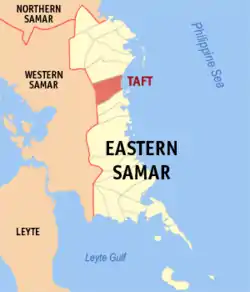
 Map of Eastern Samar with Taft highlighted | |
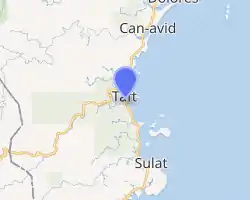
OpenStreetMap 
| |
.svg.png.webp) Taft Location within the Philippines | |
| Coordinates: 11°54′N 125°25′E | |
| Country | |
| Region | Eastern Visayas (Region VIII) |
| Province | Eastern Samar |
| District | Lone District |
| Named for | William Howard Taft |
| Barangays | 24 (see Barangays) |
| Government | |
| • Type | Sangguniang Bayan |
| • Mayor | Gina A. Ty |
| • Vice Mayor | Ma. Concepcion A. Hilario |
| • Representative | Maria Fe R. Abunda |
| • Councilors | List
|
| • Electorate | 14,510 voters (2019) |
| Area | |
| • Total | 231.27 km2 (89.29 sq mi) |
| Elevation | 22 m (72 ft) |
| Population | |
| • Total | 18,915 |
| • Density | 82/km2 (210/sq mi) |
| • Households | 4,376 |
| Economy | |
| • Income class | 4th municipal income class |
| • Poverty incidence | 41.89% (2015)[4] |
| • Revenue | ₱80,128,753.59 (2016) |
| Time zone | UTC+8 (PST) |
| ZIP code | 6816 |
| PSGC | |
| IDD : area code | +63 (0)55 |
| Climate type | tropical rainforest climate |
| Native languages | Waray Tagalog |
| Website | taft-esamar |
It is bounded on the north by the town of Can-avid and on the south-southeast by the town of Sulat.
The municipality was named in honor of former United States President William Howard Taft, who served as Governor-General of the Philippines during the first decade of the 20th century.
Barangays
Taft is politically subdivided into 24 barangays. [2]
- Batiawan
- Beto
- Binaloan
- Bongdo
- Dacul
- Danao
- Del Remedios
- Gayam
- Lomatud (Burak)
- Mabuhay
- Malinao
- Mantang
- Nato
- Pangabutan
- Poblacion Barangay 1
- Poblacion Barangay 2
- Poblacion Barangay 3
- Poblacion Barangay 4
- Poblacion Barangay 5
- Poblacion Barangay 6 (Bliss)
- Polangi
- San Luis
- San Pablo
- San Rafael
History
Taft is one of the ancient pueblos in Samar situated in the eastern coast which was called Tubabao or Tubabaw in early times. This town was originally named after the river called Malinaw, but since the river causes heavy floods during rainy season, people began calling the place Tubig, which means water in Waray-Waray.[5]
Demographics
| Year | Pop. | ±% p.a. |
|---|---|---|
| 1903 | 3,031 | — |
| 1918 | 3,866 | +1.64% |
| 1939 | 5,743 | +1.90% |
| 1948 | 7,078 | +2.35% |
| 1960 | 10,463 | +3.31% |
| 1970 | 11,296 | +0.77% |
| 1975 | 12,554 | +2.14% |
| 1980 | 14,545 | +2.99% |
| 1990 | 13,449 | −0.78% |
| 1995 | 16,613 | +4.04% |
| 2000 | 16,435 | −0.23% |
| 2007 | 16,362 | −0.06% |
| 2010 | 17,183 | +1.80% |
| 2015 | 18,915 | +1.85% |
| Source: Philippine Statistics Authority [3] [6] [7][8] | ||
The population of Taft, Eastern Samar, in the 2015 census was 18,915 people, [3] with a density of 82 inhabitants per square kilometre or 210 inhabitants per square mile.
Climate
| Climate data for Taft, Eastern Samar | |||||||||||||
|---|---|---|---|---|---|---|---|---|---|---|---|---|---|
| Month | Jan | Feb | Mar | Apr | May | Jun | Jul | Aug | Sep | Oct | Nov | Dec | Year |
| Average high °C (°F) | 27 (81) |
27 (81) |
28 (82) |
29 (84) |
30 (86) |
30 (86) |
29 (84) |
29 (84) |
29 (84) |
29 (84) |
28 (82) |
28 (82) |
29 (83) |
| Average low °C (°F) | 22 (72) |
22 (72) |
22 (72) |
23 (73) |
24 (75) |
24 (75) |
24 (75) |
24 (75) |
24 (75) |
24 (75) |
23 (73) |
23 (73) |
23 (74) |
| Average precipitation mm (inches) | 97 (3.8) |
64 (2.5) |
69 (2.7) |
58 (2.3) |
98 (3.9) |
161 (6.3) |
167 (6.6) |
140 (5.5) |
158 (6.2) |
171 (6.7) |
169 (6.7) |
154 (6.1) |
1,506 (59.3) |
| Average rainy days | 17.1 | 13.4 | 14.8 | 15.2 | 21.1 | 25.2 | 26.8 | 25.4 | 25.5 | 26.5 | 23.0 | 20.3 | 254.3 |
| Source: Meteoblue[9] | |||||||||||||
Notable people
- Andres Pagaran - poet and songwriter[10]
References
- Municipality of Taft | (DILG)
- "Province: Eastern Samar". PSGC Interactive. Quezon City, Philippines: Philippine Statistics Authority. Retrieved 12 November 2016.
- Census of Population (2015). "Region VIII (Eastern Visayas)". Total Population by Province, City, Municipality and Barangay. PSA. Retrieved 20 June 2016.
- "PSA releases the 2015 Municipal and City Level Poverty Estimates". Quezon City, Philippines. Retrieved 12 October 2019.
- Kobak, Cantius (2002). Historical Sketches of the Pueblos of Samar and Leyte: 1580-1900. Milwaukee, Wisconsin: Unpublished. p. 724 - 760.
- Census of Population and Housing (2010). "Region VIII (Eastern Visayas)". Total Population by Province, City, Municipality and Barangay. NSO. Retrieved 29 June 2016.
- Censuses of Population (1903–2007). "Region VIII (Eastern Visayas)". Table 1. Population Enumerated in Various Censuses by Province/Highly Urbanized City: 1903 to 2007. NSO.
- "Province of Eastern Samar". Municipality Population Data. Local Water Utilities Administration Research Division. Retrieved 17 December 2016.
- "Taft, Eastern Samar : Average Temperatures and Rainfall". Meteoblue. Retrieved 31 December 2018.
- Sugbo, Victor, ed. (1995). Tinipigan: An Anthology of Waray Literature. Manila, Philippines: National Commission for Culture and the Arts. p. 272. OCLC 645852700. Retrieved 27 September 2019.
External links
| Wikimedia Commons has media related to Taft, Eastern Samar. |