Maydolong
Maydolong, officially the Municipality of Maydolong (Waray: Bungto han Maydolong; Tagalog: Bayan ng Maydolong), is a 4th class municipality in the province of Eastern Samar, Philippines. According to the 2015 census, it has a population of 14,743 people. [3]
Maydolong | |
|---|---|
| Municipality of Maydolong | |
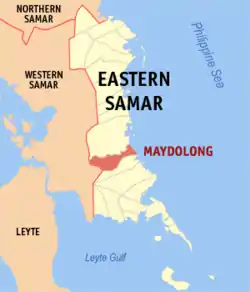 Map of Eastern Samar with Maydolong highlighted | |
OpenStreetMap 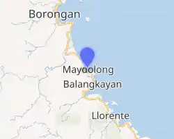
| |
.svg.png.webp) Maydolong Location within the Philippines | |
| Coordinates: 11°30′N 125°30′E | |
| Country | |
| Region | Eastern Visayas (Region VIII) |
| Province | Eastern Samar |
| District | Lone District |
| Founded | May 1, 1951 |
| Barangays | 20 (see Barangays) |
| Government | |
| • Type | Sangguniang Bayan |
| • Mayor | Godofredo T. Garado |
| • Vice Mayor | Louie A. Borja |
| • Representative | Maria Fe R. Abunda |
| • Councilors | List
|
| • Electorate | 11,088 voters (2019) |
| Area | |
| • Total | 399.63 km2 (154.30 sq mi) |
| Elevation | 18 m (59 ft) |
| Population | |
| • Total | 14,743 |
| • Density | 37/km2 (96/sq mi) |
| • Households | 3,224 |
| Economy | |
| • Income class | 4th municipal income class |
| • Poverty incidence | 39.94% (2015)[4] |
| • Revenue | ₱95,085,424.81 (2016) |
| Time zone | UTC+8 (PST) |
| ZIP code | 6802 |
| PSGC | |
| IDD : area code | +63 (0)55 |
| Climate type | tropical rainforest climate |
| Native languages | Waray Tagalog |
| Website | www |
Etymology
There are two stories about the naming of Maydolong. Officially accepted by the Sangguniang Bayan is the story of a fisherman who used to travel to the village of Matnog. Because they needed to rest from their travel along the east coast of Samar, these fisherman used to say "Matnog it Dolong" which means "the bow must point to Matnog" in the local dialect. This saying got shortened to Maydolong, which eventually became the name of the village.[5]
History
Maydolong comprised barrios Maydolong, Balogo, Maybocog, Omawas, Tagaslian, Kampakirit, Suribao, Mayburak, Kanmanungdong, Malobago, Tabi, Maytigbao, and Kanluterio, which used to belong to the Municipality of Borongan, Eastern Samar.[6]
Barangays
Maydolong is politically subdivided into 20 barangays. [2]
- Camada
- Campakerit (Botay)
- Canloterio
- Del Pilar
- Guindalitan
- Lapgap
- Malobago
- Maybocog
- Maytigbao
- Omawas
- Patag
- Barangay Poblacion 1
- Barangay Poblacion 2
- Barangay Poblacion 3
- Barangay Poblacion 4
- Barangay Poblacion 5
- Barangay Poblacion 6
- Barangay Poblacion 7
- San Gabriel
- Tagaslian
Demographics
| Year | Pop. | ±% p.a. |
|---|---|---|
| 1960 | 7,827 | — |
| 1970 | 8,424 | +0.74% |
| 1975 | 12,317 | +7.92% |
| 1980 | 11,353 | −1.62% |
| 1990 | 10,656 | −0.63% |
| 1995 | 12,201 | +2.57% |
| 2000 | 11,741 | −0.82% |
| 2007 | 12,766 | +1.16% |
| 2010 | 13,614 | +2.37% |
| 2015 | 14,743 | +1.53% |
| Source: Philippine Statistics Authority [3] [7] [8][9] | ||
The population of Maydolong in the 2015 census was 14,743 people, [3] with a density of 37 inhabitants per square kilometre or 96 inhabitants per square mile.
Climate
| Climate data for Maydolong, Eastern Samar | |||||||||||||
|---|---|---|---|---|---|---|---|---|---|---|---|---|---|
| Month | Jan | Feb | Mar | Apr | May | Jun | Jul | Aug | Sep | Oct | Nov | Dec | Year |
| Average high °C (°F) | 27 (81) |
28 (82) |
28 (82) |
30 (86) |
30 (86) |
30 (86) |
29 (84) |
29 (84) |
29 (84) |
29 (84) |
28 (82) |
28 (82) |
29 (84) |
| Average low °C (°F) | 22 (72) |
22 (72) |
22 (72) |
23 (73) |
24 (75) |
24 (75) |
24 (75) |
24 (75) |
24 (75) |
24 (75) |
23 (73) |
23 (73) |
23 (74) |
| Average precipitation mm (inches) | 114 (4.5) |
81 (3.2) |
94 (3.7) |
81 (3.2) |
119 (4.7) |
192 (7.6) |
186 (7.3) |
158 (6.2) |
167 (6.6) |
185 (7.3) |
202 (8.0) |
176 (6.9) |
1,755 (69.2) |
| Average rainy days | 18.6 | 14.7 | 16.8 | 17.8 | 22.3 | 25.9 | 27.5 | 26.2 | 26.6 | 27.0 | 24.6 | 22.3 | 270.3 |
| Source: Meteoblue [10] | |||||||||||||
References
- Municipality of Maydolong | (DILG)
- "Province: Eastern Samar". PSGC Interactive. Quezon City, Philippines: Philippine Statistics Authority. Retrieved 12 November 2016.
- Census of Population (2015). "Region VIII (Eastern Visayas)". Total Population by Province, City, Municipality and Barangay. PSA. Retrieved 20 June 2016.
- "PSA releases the 2015 Municipal and City Level Poverty Estimates". Quezon City, Philippines. Retrieved 12 October 2019.
- "The History of Maydolong". Municipality of Maydolong. Archived from the original on 2011-08-20. Retrieved 2011-04-13.
- "An act creating the municipality of Maydolong, province of Samar". LawPH.com. Retrieved 2011-04-09.
- Census of Population and Housing (2010). "Region VIII (Eastern Visayas)". Total Population by Province, City, Municipality and Barangay. NSO. Retrieved 29 June 2016.
- Censuses of Population (1903–2007). "Region VIII (Eastern Visayas)". Table 1. Population Enumerated in Various Censuses by Province/Highly Urbanized City: 1903 to 2007. NSO.
- "Province of Eastern Samar". Municipality Population Data. Local Water Utilities Administration Research Division. Retrieved 17 December 2016.
- "Maydolong, Eastern Samar : Average Temperatures and Rainfall". Meteoblue. Retrieved 31 December 2018.
External links
- Maydolong Profile at PhilAtlas.com
- Official Website of the Municipality Maydolong
- Philippine Standard Geographic Code
- Philippine Census Information
- Local Governance Performance Management System
Places adjacent to Maydolong | ||||||||||
|---|---|---|---|---|---|---|---|---|---|---|
| ||||||||||
