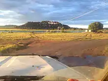
Gunbalanya, Northern Territory
Gunbalanya (also spelt Kunbarlanja, and historically referred to as Oenpelli) is an Aboriginal Australian town in west Arnhem Land in the Northern Territory of Australia, about 300 kilometres (190 mi) east of Darwin. The main language spoken in the community is Kunwinjku (aka Bininj Gun-Wok). At the 2016 Australian census, Gunbalanya had a population of 1,116.

Only accessible by air in the wet season, Gunbalanya is known for its Aboriginal art, in particular rock art and bark painting. It has a range of services, including a police station, school and community arts centre, Injalak Arts.
It is the nearest town to the Awunbarna, also known as Mount Borradaile, an Aboriginal sacred site and the location of significant Indigenous Australian rock art.
Etymology and history
The area now known as Gunbalanya was originally called "Uwunbarlany" by Erre-speaking people, who were its original inhabitants.[1] Oenpelli was the way Paddy Cahill (1863–1923),[2] the founder of the original cattle station in the area, pronounced the local word.[3] The present toponym is an anglisation of the word Kunbarlanja[4] current in Kunwinjku, the language of the people who now live there, who began moving into the area from the east following the Cahill's establishment of his cattle station there in 1909.
Oenpelli, as it was known then, was established by the Rev. Alfred Dyer as a mission in 1925 by the Church of England's Church Missionary Society, on the former cattle station.[5] Dyer and his wife Mary established a typical mission station, with church, school, dispensary, garden and store, to which they added pastoral work with feral cattle and horses. Among those who attended the mission school was the celebrated Gagudju elder and interpreter of culture, Bill Neidjie.[6]
Oenpelli remained a mission until 1975, when responsibility was transferred to an Aboriginal town council and the name was changed to Gunbalanya.
The 1948 American-Australian Scientific Expedition to Arnhem Land visited Oenpelli for three months and collected a large array of local artefacts, art, and specimens.
Use of the name Oenpelli
The large and uncommon Oenpelli python, Morelia oenpelliensis, shares the historic name of this community,[7] as does Oenpelli bloodwood, Corymbia dunlopiana.[8]
A geological event known as the Oenpelli Dolerite intrusive event occurred about 1,720 million years ago.[9][10]
People and surrounds
The local people speak Kunwinjku (aka Bininj Gun-Wok), and are a grouping of the Bininj peoples. At the 2016 Australian census, Gunbalanya had a population of 1,116.[11] 88.6% of the population identified as Aboriginal and/or Torres Strait Islander.[12]
Gunbalanya is the largest town in the area and the nearest population centre to Awunbarna, also known as Mount Borradaile, a mountain about 120 metres (390 ft) above sea level about 34.9 kilometres (21.7 mi) away.[13][14] Awunbarna is a sacred site and the location of a significant number of rock paintings.[15][16] A study published in 2020 recording the Maliwawa Figures describes paintings at 87 sites across western Arnhem Land from Awunbarna westwards to the Wellington Range.[17][18]
Access, facilities and tourism
The sealed Arnhem Highway links Darwin to Jabiru, the town within Kakadu National Park. About 4 kilometres (2.5 mi) before Jabiru, the sealed road turns off to Ubirr, the Border Store, Cahill's Crossing on the East Alligator River and Oenpelli. The road is dirt from the East Alligator to just before Gunbalanya, a distance of about 16 kilometres (9.9 mi). While this road is generally navigable by four-wheel drive vehicle, the river crossing is a causeway which is closed by flooding during the wet season (November to April) and at high tides.
Dry season travellers are able to drive the 300 kilometres (190 mi) from Darwin in about three hours and 60 kilometres (37 mi) from Jabiru in under an hour. Northern Land Council permits are required to cross the East Alligator River, the western boundary of Arnhem Land, and travel east to Gunbalanya, obtainable from offices in Darwin or Jabiru. These may take up to two weeks to finalise, and many visitors prefer to see Arnhem Land through an organised tour operation.
Oenpelli Airport is a sealed all weather airstrip located in Gunbalanya, and a number of companies offer charter flights to and from this airport.
The town is regarded as one of the major Aboriginal towns in Arnhem Land, and includes a school (pre-school to Year 12), health clinic, service station, police station, aged care, recreational clubs, community arts centre (Injalak Arts) and various stores.
The Stone Country Festival (formerly Gunbalanya Cultural Open Day) is usually held in August and access for this is allowed without permit. Though an annual event, it is sometimes not able to be organised in a given year.
The local radio station is called "RIBS" for Remote Indigenous Broadcasting Service.
Indigenous art
Rock art
Western Arnhem Land is home to some of the most significant rock art in the world.
Local artistic traditions are continued and adapted by the Injalak Arts Centre. Injalak Arts is named after nearby Injalak Hill, which has many rock art galleries and is the main tourist attraction in Gunbalanya.
Bark painting
In the 1960s the mission at Oenpelli encouraged traditional rock painting artists to paint on bark. These painted barks were sold to anthropologists and travellers. This soon became a cottage industry, and several important Aboriginal artists, including Lofty Bardayal, Mick Kubarrku[19] and Dick Murramurra[20] transferred their rock art skills to bark. These bark paintings are now held in art galleries in Australia and across the world. Exhibitions of bark paintings include "Old Masters"[21] at the National museum of Australia and "Crossing Country"[22] at the Art Gallery of New South Wales.
Climate
| Climate data for Oenpelli (Gunbalanya) | |||||||||||||
|---|---|---|---|---|---|---|---|---|---|---|---|---|---|
| Month | Jan | Feb | Mar | Apr | May | Jun | Jul | Aug | Sep | Oct | Nov | Dec | Year |
| Record high °C (°F) | 38.1 (100.6) |
39.0 (102.2) |
38.8 (101.8) |
38.8 (101.8) |
37.0 (98.6) |
37.5 (99.5) |
36.5 (97.7) |
39.0 (102.2) |
39.7 (103.5) |
42.2 (108.0) |
41.9 (107.4) |
39.9 (103.8) |
42.2 (108.0) |
| Average high °C (°F) | 33.1 (91.6) |
32.5 (90.5) |
32.9 (91.2) |
34.0 (93.2) |
33.3 (91.9) |
32.1 (89.8) |
32.1 (89.8) |
33.7 (92.7) |
35.9 (96.6) |
37.5 (99.5) |
37.1 (98.8) |
34.9 (94.8) |
34.1 (93.4) |
| Average low °C (°F) | 24.5 (76.1) |
24.5 (76.1) |
24.4 (75.9) |
23.6 (74.5) |
21.9 (71.4) |
19.7 (67.5) |
18.3 (64.9) |
18.5 (65.3) |
20.1 (68.2) |
22.4 (72.3) |
24.1 (75.4) |
24.5 (76.1) |
22.2 (72.0) |
| Record low °C (°F) | 17.5 (63.5) |
21.0 (69.8) |
17.9 (64.2) |
17.0 (62.6) |
10.0 (50.0) |
10.0 (50.0) |
4.4 (39.9) |
9.2 (48.6) |
11.1 (52.0) |
13.1 (55.6) |
18.0 (64.4) |
12.5 (54.5) |
4.4 (39.9) |
| Average rainfall mm (inches) | 340.9 (13.42) |
335.2 (13.20) |
279.6 (11.01) |
83.6 (3.29) |
14.0 (0.55) |
1.6 (0.06) |
2.2 (0.09) |
1.0 (0.04) |
4.7 (0.19) |
25.8 (1.02) |
110.1 (4.33) |
224.7 (8.85) |
1,414 (55.67) |
| Average rainy days | 20.5 | 19.5 | 18.1 | 6.9 | 1.7 | 0.4 | 0.3 | 0.2 | 0.7 | 2.6 | 9.3 | 16.4 | 96.6 |
| Source: [23] | |||||||||||||
Notes and references
Notes
- Birch 2011, p. 313, n.3.
- Clinch 1979.
- Mulvaney 2004, p. 37.
- Garde, Murray. "Kunbarlanja". Bininj Kunwok online dictionary. Bininj Kunwok Regional Language Centre. Retrieved 16 June 2019.
- Mulvaney 2004, p. 58.
- Mackinolty 2002.
- Beolens, Bo; Watkins, Michael; Grayson, Michael (2011). The Eponym Dictionary of Reptiles. Baltimore: Johns Hopkins University Press. xiii + 296 pp. ISBN 978-1-4214-0135-5. ("Oenpelli", p. 193).
- Dean Nicolle. "Eucalypt Diversity Gallery". Currency Creek Arboretum. Retrieved 5 October 2020.
- Ranford, Cath; Melville, Paul; Bentley, Craig (August 2008). "Wellington Range Project Northern Territory EL 5893 Relinquishment Report" (PDF). Report No.: WR08-02. Cameco Australia Pty Lt. Retrieved 5 October 2020. Cite journal requires
|journal=(help) - "Definition card for: Oenpelli Dolerite". Australian Stratigraphic Units Database. Australian Government. Geoscience Australia. Retrieved 5 October 2020.
...licensed under the Creative Commons Attribution 3.0 Australia Licence.
- Gunbalanya 2016.
- "2016 Census QuickStats: Gunbalanya". quickstats.censusdata.abs.gov.au. Retrieved 4 October 2020.
- "Awunbarna (Mount Borradaile)". bonzle.com. Retrieved 4 October 2020.
- "Mt. Borradaile, Arnhem Land, Northern Territory, Australia". Cruise Centres. Retrieved 4 October 2020.
- Grove, Margaret (2003). "Woman, man, land: an example from Arnhem Land, North Australia". Before Farming. 2003 (2): 1–15. doi:10.3828/bfarm.2003.2.6. ISSN 2056-3264.
- Roberts, David Andrew; Parker, Adrian (2003), Ancient ochres: the Aboriginal rock paintings of Mount Borradaile, JB Books
- S.C.Taçon, Paul; May, Sally K. (30 September 2020). "Introducing the Maliwawa Figures: a previously undescribed rock art style found in Western Arnhem Land". The Conversation. Retrieved 4 October 2020.
- Nichele, Amelia (4 October 2020). "A missing part of the rock art gallery". Cosmos Magazine.
- "Mick Kubarrku oenpelli Artist | Mick Balang Kubarrku | sell Kubarrku". Aboriginal Bark Paintings. 26 October 2017. Retrieved 3 January 2019.
- "Dick Murramurra". Aboriginal Bark Paintings. 28 September 2017. Retrieved 3 January 2019.
- "National Museum of Australia - Old Masters: Australia's great bark artists". www.nma.gov.au. Retrieved 3 January 2019.
- "crossing country". www.artgallery.nsw.gov.au. Retrieved 3 January 2019.
- "Oenpelli". Climate statistics for Australian locations. Bureau of Meteorology. Retrieved 26 November 2011.
References
- Birch, Bruce (2011). "The American Clever Man (Marrkijbu Burdan Merika)". In Thomas, Martin; Neale, Margo (eds.). Exploring the Legacy of the 1948 Arnhem Land Expedition. Australian National University. pp. 313–335. ISBN 978-1-921-66645-2.
- Clinch, M. A. (1979). "Cahill, Patrick (Paddy) (1863–1923)". Australian Dictionary of Biography. 7. Melbourne University Press.
- Mackinolty, Chips (17 June 2002). "The man who attended his own wake:Big Bill Neidjie, Kakadu Man, circa WWI-2002". The Sydney Morning Herald.
- Mulvaney, Derek John (2004). Paddy Cahill of Oenpelli. Aboriginal Studies Press. ISBN 978-0-855-75456-3.
- "Gunbalanya". West Arnhem Regional Council. 2016.
Further reading
- Birch, Bruce 'Erre Mengerrdji Urningangk: Three Languages From The Alligator Rivers Region Of North Western Arnhem Land, Northern Territory, Australia', Gundjeihmi Aboriginal Corporation, 2006
- Aboriginal Arts Board of the Australia Council, Oenpelli Bark Painting, Ure Smith, 1979
- Cole, Keith, A History of Oenpelli, Nungalinya Publications, 1975
- Cole, Keith, Arnhem Land: Places and People, Rigby, 1980
External links
- West Arnhem Regional Council
- Injalak Stone Country Arts and Crafts
- West Arnhem College Gunbalanya
- Northern Land Council
- Kunwinjku language
- Online Kunwinjku dictionary