Gurbhakot
Gurbhakot (Nepali: गुर्भाकोट) is an urban municipality located in Surkhet District of Karnali province of Nepal.
Gurbhakot
गुर्भाकोट नगरपालिका | |
|---|---|
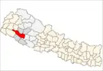
 Gurbhakot Location in Nepal | |
| Coordinates: 28.439042°N 81.852828°E | |
| Country | |
| Province | Karnali |
| District | Surkhet |
| Total Wards | 14 |
| Established | 1 October 2015 |
| Established as | Shubhaghat Gangamala |
| Government | |
| • Mayor | Mr. Hasta Pun (NC) |
| • Deputy Mayor | Mrs. Maina BK (NC) |
| Area of Municipality | |
| • Total | 228.62 km2 (88.27 sq mi) |
| Population (2011) | |
| • Total | 43,765 |
| Languages | |
| • Official | Nepali |
| Time zone | UTC+5:45 (NST) |
| Website | official website |
According to 2011 Nepal census the total population of the municipality is 43,765 and the total area of the municipality is 228.62 square kilometres (88.27 sq mi). The municipality is divided into total 14 wards. Malarani, Dharapani and Sahare VDC were Incorporated with Subhaghat Gangamala municipality in 2017 when government cancelled all old administration system and introduce new 753 local level administrative body.[1]
The municipality is surrounded by Salyan in east, Bheriganga in west, Simta and Chingad in north and Salyan in south.[2]
History
Subhaghat Gangamala municipality was established on 1 December 2015 merging 4 VDC Dahachaur, Ghumkhahare, Gumi and Mehelkuna.
In 2017 when new administrative system applied Malarani, Dharapani and Sahare incorporated with Subhaghat Gangamala municipality and renamed as Gurbhakot municipality.[3][4]
References
- "स्थानीय तहहरुको विवरण". www.mofaga.gov.np. Ministry of Federal Affairs and General Administration (Nepal). Archived from the original on 31 August 2018. Retrieved 12 July 2018.
- "District Corrected Last for RAJAPATRA" (PDF). www.mofald.gov.np. Retrieved 12 July 2018.
- "26 new Municipalities announced". infonepal.net. Archived from the original on 2015-10-05.
- "गुर्भाकोट नगरपालिकाको वेवसाइटमा तपाईहरुलाई स्वागत छ।". www.gurbhakotmun.gov.np. Retrieved 15 July 2018.
External links