Höpfingen
Höpfingen, sometimes spelled Hoepfingen, is a municipality in the district of Neckar-Odenwald-Kreis, in Baden-Württemberg, Germany.
Höpfingen | |
|---|---|
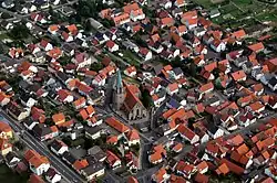 Aerial view of St. Ägidius Church and surrounding area in the Höpfingen subdivision | |
 Coat of arms | |
Location of Höpfingen within Neckar-Odenwald-Kreis district  | |
 Höpfingen  Höpfingen | |
| Coordinates: 49°36′5″N 9°25′51″E | |
| Country | Germany |
| State | Baden-Württemberg |
| Admin. region | Karlsruhe |
| District | Neckar-Odenwald-Kreis |
| Subdivisions | 2 |
| Government | |
| • Mayor | Adalbert Hauck (CDU) |
| Area | |
| • Total | 30.49 km2 (11.77 sq mi) |
| Elevation | 377 m (1,237 ft) |
| Population (2019-12-31)[1] | |
| • Total | 2,979 |
| • Density | 98/km2 (250/sq mi) |
| Time zone | UTC+01:00 (CET) |
| • Summer (DST) | UTC+02:00 (CEST) |
| Postal codes | 74746 |
| Dialling codes | 06283 |
| Vehicle registration | MOS, BCH |
| Website | www.hoepfingen.de |
Administration
The municipality consists of two subdivisions:
- Höpfingen
- Waldstetten
Geography
The district lies on the southeastern slope of the Odenwald mountain range. Part is included with the Neckartal-Odenwald Nature Park, one of the largest national parks in Baden-Württemberg.
Höpfingen, in the northern part of the municipality, has forests, fields and meadows. To the south, the town of Waldstetten sits in a valley with several streams running through.[2]
References
- "Bevölkerung nach Nationalität und Geschlecht am 31. Dezember 2019". Statistisches Landesamt Baden-Württemberg (in German). September 2020.
- "Unsere Ortsteile". Retrieved 2 February 2016.
Towns and municipalities in Neckar-Odenwald (district) | ||
|---|---|---|
Coat of arms | ||
| Authority control |
|---|
This article is issued from Wikipedia. The text is licensed under Creative Commons - Attribution - Sharealike. Additional terms may apply for the media files.