Hadley, Minnesota
Hadley (/ˈhædliː/ (![]() listen), HAD-lee)[6] is a city in Murray County, Minnesota, United States. The population was 61 at the 2010 census.[7]
listen), HAD-lee)[6] is a city in Murray County, Minnesota, United States. The population was 61 at the 2010 census.[7]
Hadley | |
|---|---|
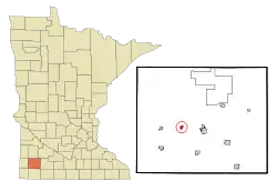 Location of Hadley within Murray County, Minnesota | |
| Coordinates: 43°59′59″N 95°51′11″W | |
| Country | United States |
| State | Minnesota |
| County | Murray |
| Government | |
| • Type | Mayor − Council |
| • Mayor | Rick Like |
| Area | |
| • Total | 0.41 sq mi (1.06 km2) |
| • Land | 0.29 sq mi (0.76 km2) |
| • Water | 0.11 sq mi (0.30 km2) |
| Elevation | 1,706 ft (520 m) |
| Population | |
| • Total | 61 |
| • Estimate (2019)[3] | 57 |
| • Density | 193.88/sq mi (74.77/km2) |
| Time zone | UTC-6 (Central (CST)) |
| • Summer (DST) | UTC-5 (CDT) |
| ZIP code | 56151 |
| Area code(s) | 507 |
| FIPS code | 27-26450[4] |
| GNIS feature ID | 0644553[5] |
| Website | cityofhadley.com |
Geography
According to the United States Census Bureau, the city has a total area of 0.39 square miles (1.01 km2), of which 0.28 square miles (0.73 km2) is land and 0.11 square miles (0.28 km2) is water.[8] It has a latitude of 44°00'N and a longitude of 95°51'W.
Minnesota State Highway 30 and Murray County Road 29 are the main routes in the community.
Demographics
| Historical population | |||
|---|---|---|---|
| Census | Pop. | %± | |
| 1880 | 22 | — | |
| 1910 | 136 | — | |
| 1920 | 147 | 8.1% | |
| 1930 | 105 | −28.6% | |
| 1940 | 162 | 54.3% | |
| 1950 | 139 | −14.2% | |
| 1960 | 151 | 8.6% | |
| 1970 | 119 | −21.2% | |
| 1980 | 137 | 15.1% | |
| 1990 | 94 | −31.4% | |
| 2000 | 81 | −13.8% | |
| 2010 | 61 | −24.7% | |
| 2019 (est.) | 57 | [3] | −6.6% |
| U.S. Decennial Census | |||
2010 census
As of the census[2] of 2010, there were 61 people, 32 households, and 20 families residing in the city. The population density was 217.9 inhabitants per square mile (84.1/km2). There were 38 housing units at an average density of 135.7 per square mile (52.4/km2). The racial makeup of the city was 100.0% White.
There were 32 households, of which 12.5% had children under the age of 18 living with them, 50.0% were married couples living together, 12.5% had a female householder with no husband present, and 37.5% were non-families. 37.5% of all households were made up of individuals, and 15.6% had someone living alone who was 65 years of age or older. The average household size was 1.91 and the average family size was 2.40.
The median age in the city was 56.2 years. 6.6% of residents were under the age of 18; 9.7% were between the ages of 18 and 24; 13.2% were from 25 to 44; 40.9% were from 45 to 64; and 29.5% were 65 years of age or older. The gender makeup of the city was 45.9% male and 54.1% female.
2000 census
As of the census[4] of 2000, there were 81 people, 36 households, and 27 families residing in the city. The population density was 292.7 people per square mile (111.7/km2). There were 38 housing units at an average density of 137.3 per square mile (52.4/km2). The racial makeup of the city was 100.00% White.
There were 36 households, out of which 22.2% had children under the age of 18 living with them, 69.4% were married couples living together, 5.6% had a female householder with no husband present, and 25.0% were non-families. 25.0% of all households were made up of individuals, and 11.1% had someone living alone who was 65 years of age or older. The average household size was 2.25 and the average family size was 2.67.
In the city, the population was spread out, with 17.3% under the age of 18, 7.4% from 18 to 24, 17.3% from 25 to 44, 27.2% from 45 to 64, and 30.9% who were 65 years of age or older. The median age was 48 years. For every 100 females, there were 113.2 males. For every 100 females age 18 and over, there were 109.4 males.
The median income for a household in the city was $31,406, and the median income for a family was $31,667. Males had a median income of $30,536 versus $16,429 for females. The per capita income for the city was $22,518. None of the population or the families were below the poverty line.
History
Hadley was founded as "Summit Lake" on October 31, 1879. In 1880 (when it established a post office), it was renamed for the cities of Hadley in New York, Pennsylvania, and Massachusetts. It was incorporated as a village on September 1, 1903.
Politics
Hadley is located in Minnesota's 7th congressional district, represented by Collin Peterson, a Democrat. At the state level, Hadley is located in Senate District 22, represented by Republican Bill Weber, and in House District 22A, represented by Republican Joe Schomacker.
| Year | Republican | Democratic | Third parties |
|---|---|---|---|
| 2020 | 40.0% 16 | 55.0% 22 | 5.0% 2 |
| 2016 | 33.3% 12 | 58.3% 21 | 8.4% 3 |
| 2012 | 22.2% 8 | 72.2% 26 | 5.6% 2 |
| 2008 | 27.1% 13 | 68.9% 33 | 4.0% 2 |
| 2004 | 21.7% 10 | 76.1% 35 | 2.2% 1 |
| 2000 | 20.0% 9 | 73.3% 33 | 6.7% 3 |
References
- "2019 U.S. Gazetteer Files". United States Census Bureau. Retrieved July 26, 2020.
- "U.S. Census website". United States Census Bureau. Retrieved 2012-11-13.
- "Population and Housing Unit Estimates". United States Census Bureau. May 24, 2020. Retrieved May 27, 2020.
- "U.S. Census website". United States Census Bureau. Retrieved 2008-01-31.
- "US Board on Geographic Names". United States Geological Survey. 2007-10-25. Retrieved 2008-01-31.
- "Hadley". Merriam-Webster. Retrieved 12 November 2014.
- "2010 Census Redistricting Data (Public Law 94-171) Summary File". American FactFinder. United States Census Bureau. Retrieved 27 April 2011.
- "US Gazetteer files 2010". United States Census Bureau. Retrieved 2012-11-13.
- https://www.lrl.mn.gov/mngov/electionresults. Missing or empty
|title=(help)
External links
Municipalities and communities of Murray County, Minnesota, United States | ||
|---|---|---|
| Cities |  Map of Minnesota highlighting Murray County | |
| Townships | ||
| CDP | ||
| Unincorporated communities | ||
| ||