Hamina
Hamina (Finnish pronunciation: [ˈhɑminɑ]; Swedish: Fredrikshamn, Finland Swedish: [freːdriksˈhɑmn] (![]() listen), Sweden Swedish: [freːdrɪksˈhamːn]) is a town and a municipality of Finland. It is located approximately 145 km (90 mi) east of the country's capital Helsinki, in the Kymenlaakso region, and formerly the province of Southern Finland. The municipality's population is 20,024 (as of 31 July 2020)[6] and covers an area of 1,155.14 square kilometres (446.00 sq mi), of which 545.66 km2 (210.68 sq mi)
is water.[1] The population density is
32.85 inhabitants per square kilometre (85.1/sq mi). The population of the central town is approximately 10,000. Hamina is unilingually Finnish speaking.
listen), Sweden Swedish: [freːdrɪksˈhamːn]) is a town and a municipality of Finland. It is located approximately 145 km (90 mi) east of the country's capital Helsinki, in the Kymenlaakso region, and formerly the province of Southern Finland. The municipality's population is 20,024 (as of 31 July 2020)[6] and covers an area of 1,155.14 square kilometres (446.00 sq mi), of which 545.66 km2 (210.68 sq mi)
is water.[1] The population density is
32.85 inhabitants per square kilometre (85.1/sq mi). The population of the central town is approximately 10,000. Hamina is unilingually Finnish speaking.
Hamina
Fredrikshamn | |
|---|---|
Town | |
| Haminan kaupunki Fredrikshamns stad | |
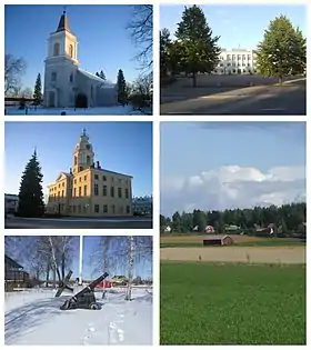 Clockwise from top-left: St. Mary's Church, the Reserve Officer School, the countryside of Husula neighbourhood, a view from the Sailor Pavilion towards Tervasaari and the historical Town Hall. | |
 Flag  Coat of arms | |
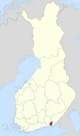 Location of Hamina in Finland | |
| Coordinates: 60°34′N 027°12′E | |
| Country | |
| Region | Kymenlaakso |
| Sub-region | Kotka-Hamina |
| Charter | 1653 |
| Government | |
| • Town manager | Hannu Muhonen |
| Area (2018-01-01)[1] | |
| • Total | 1,155.14 km2 (446.00 sq mi) |
| • Land | 609.51 km2 (235.33 sq mi) |
| • Water | 545.66 km2 (210.68 sq mi) |
| Area rank | 138th largest in Finland |
| Population (2020-07-31)[2] | |
| • Total | 20,024 |
| • Rank | 57th largest in Finland |
| • Density | 32.85/km2 (85.1/sq mi) |
| Population by native language | |
| • Finnish | 96.1% (official) |
| • Swedish | 0.4% |
| • Others | 3.5% |
| Population by age | |
| • 0 to 14 | 15.1% |
| • 15 to 64 | 63.8% |
| • 65 or older | 21.1% |
| Time zone | UTC+02:00 (EET) |
| • Summer (DST) | UTC+03:00 (EEST) |
| Municipal tax rate[5] | 20% |
| Climate | Dfb |
| Website | www.hamina.fi |
Highway 7 (E18) is the town's road connection to Helsinki, after it was upgraded to a continuous motorway in September 2014. Hamina is also one of the most important harbors of Finland, the Port of Hamina-Kotka. The port specializes in forest products and the transit of cargo to Russia. One of Google's five European data centers is situated in Hamina.[7]
History
Vehkalahti county was mentioned in documents for the first time in 1336. At the proposal of Count Peter Brahe, the area surrounding the Vehkalahti church (nowadays St. Mary's Church) was separated from rest of Vehkalahti in 1653 and became a town called Vehkalahden Uusikaupunki (Veckelax Nystad in Swedish, "Newtown of Vehkalahti"). The town was destroyed during the Great Northern War in 1712.[8]
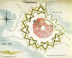
As the important foreign trade town of Vyborg was surrendered to Russia in 1721, this town (newly renamed in honour of the King Frederick I of Sweden in 1723) was intended to replace it.[9] The town, hitherto a small domestic trade port with restricted trade, was granted extensive privileges, including foreign trade. Finnish people soon shortened the name to Hamina. The rebuilding of the town took place in 1722–1724. The star-shaped fortress and the circular town plan, designed by Axel Löwen, are based on Central European and Italian Renaissance fortress concepts from the 16th century.[8] Fortress towns with a circular street plan like this are quite rare; one example is Palmanova in Italy.[10]
In 1743, Hamina was surrendered to Russia, after the Russo–Swedish War, 1741–1743, and the town of Loviisa was the next Swedish candidate for an Eastern-Finnish trade center. Hamina became a Russian frontier town, for which a fortress was desirable.
The Treaty of Fredrikshamn (1809), by which Sweden ceded Finland, including parts of the province of Lappland and the Åland Islands, was signed in Hamina. Thus Sweden was split, and the eastern half was formed into the Grand Duchy of Finland, an autonomous part of the Russian Empire. In 1812, the previously conquered territories known as Old Finland (including Hamina) were joined to the Grand Duchy.
Hamina Cadet School was founded in 1819 and was in operation until 1903. In 1920 the Reserve Officer School began in the same facilities.
Because the town was founded next to the Vehkalahti Church, the municipal center had always been inside the town borders. Vehkalahti and Hamina were consolidated in 2003, and the old coat of arms was replaced with Vehkalahti's coat of arms. The old coat of arms was readopted in January 2013.[11]
Main sights
- Town Hall: Originally built in 1798, it was renovated by Carl Ludvig Engel in 1840.
- Reserve Officer School: The site which trains reserve officers in the Army Academy of the Finnish Army
- Town Museum: It is located in a building where King Gustav III of Sweden and Empress Catherine II of Russia met in 1783.[12]
- Shopkeeper's Museum
- Google Data Center: (former Stora Enso pulp factory)
- Hamina Fortress: Built in the 18th century, it is one of the star forts in Finland. The corners of the fortress form six bastions, named after towns in Finland. The Central Bastion was added at the end of the 18th century, and is currently used for cultural events.
Churches
- St. Mary's Church, previously known as Vehkalahti Church, is the oldest building in Kymenlaakso. It was originally built in the Middle Ages, but it was burnt in 1821 and the current neoclassical exterior is designed by Carl Ludvig Engel and completed in 1828. The church has a museum dedicated to the church life from the 18th century onwards.[13][14]
- St. John's Church, formerly known as Hamina Church, was built between 1841-1843. It was designed by Carl Ludvig Engel in the neoclassical style.[15]
- Church of St. Peter and St. Paul, the Orthodox church in Hamina, was built in 1837. It was designed by Italian-French architect Louis Visconti. The architecture of the church is combination of neoclassical and Byzantine elements.[16]
Gallery
 The former coat of arms, in use from 2003 to 2012
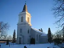 St. Mary's church
_1.jpg.webp) St. John's church
St. John's church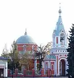 The orthodox church of Peter and Paul
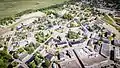 Aerial view of the town
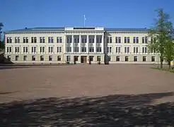 Reserve officer's school
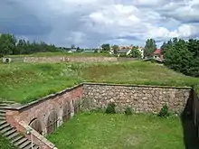 The old fortress
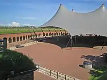 Central bastion of the fortress
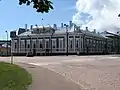 Tanelinkulma
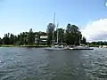 The yacht club's pavilion
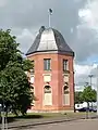 The flag tower, the only remaining part of the Helsinki bastion
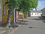 Pikkuympyräkatu; "The Little Circle Street"
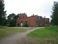 The old locomotive warehouse
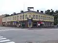 Aholaisenkulma ("The Aholainen's corner"), a historical restaurant and hotel, demolished in the autumn of 2008
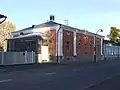 The town museum
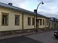 The shopkeeper's museum
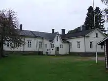 The Vehkalahti municipal museum
Notable people
- Joona Harjama (born 1993), ice hockey player
- Simo Häyhä (1905–2002), a farmer and military sniper
- Pelle Miljoona (born 1955), a musician
- Hugo Simberg (1873-1917), a painter
- Leo Mechelin (1839-1914), a professor, statesman, senator and liberal reformer
- Meri Toppelius (1863–1896), educational theorist
References
- "Area of Finnish Municipalities 1.1.2018" (PDF). National Land Survey of Finland. Retrieved 30 January 2018.
- "Suomen virallinen tilasto (SVT): Väestön ennakkotilasto [verkkojulkaisu]. Heinäkuu 2020" (in Finnish). Statistics Finland. Retrieved 13 September 2020.
- "Population according to language and the number of foreigners and land area km2 by area as of 31 December 2008". Statistics Finland's PX-Web databases. Statistics Finland. Retrieved 29 March 2009.
- "Population according to age and gender by area as of 31 December 2008". Statistics Finland's PX-Web databases. Statistics Finland. Retrieved 28 April 2009.
- "List of municipal and parish tax rates in 2011". Tax Administration of Finland. 29 November 2010. Retrieved 13 March 2011.
- "Population by municipality as of 31 December 2008". Population Information System (in Finnish and Swedish). Population Register Center of Finland. Archived from the original on 2010-12-02. Retrieved 27 March 2010.
- Hamina Data Center - Google Data centers
- Hamina
- Lindberg, Johan (May 26, 2016). "Finlands historia: 1700-talet". Uppslagsverket Finland (in Swedish). Retrieved November 30, 2017.
- Kopomaa, Timo (2005). "Kriisioloihin varautunut kaupunki" (PDF). Yhdyskuntasuunnittelu (in Finnish). Helsinki: Yhdyskuntasuunnittelun seura ry (The Finnish Society of Housing and Planning). 43 (2): 6–26. Retrieved 25 January 2009.
- Haminan vaakuna vaihtuu - Haminan kaupunki (in Finnish) Archived 2013-02-13 at Archive.today
- Hamina
- Hurmaava Hamina - The 15th century church of St Mary and church Museum Archived 2013-02-17 at Archive.today
- Churches in Finland
- Hurmaava Hamina - Church Of St John Archived 2013-02-17 at Archive.today
- Hurmaava Hamina - The Orthodox Church Of St Peter and St Paul Archived 2013-02-17 at Archive.today
- Vordingborg Kommune har 17 venskabsbyer Archived 2014-07-05 at the Wayback Machine
- Hurmaava Hamina - Info Archived 2011-11-29 at the Wayback Machine
External links
| Wikimedia Commons has media related to Hamina. |
- Official website of Hamina in English
- Guide map of Hamina
- Map of Hamina
- Hamina-Fredrikshamn at Northern Fortress
| Municipalities |  | |
|---|---|---|
| Former municipalities | ||
| Authority control |
|---|