Vyborg
Vyborg (Russian: Выборг, IPA: [ˈvɨbərk];[10] Finnish: Viipuri [ˈʋiːpuri];[11] Swedish: Viborg [ˈvǐːbɔrj] (![]() listen); German: Wiborg [ˈviːbɔʁk]) is a town in, and the administrative center of, Vyborgsky District in Leningrad Oblast, Russia. It lies on the Karelian Isthmus near the head of the Vyborg Bay, 130 km (81 miles) to the northwest of St. Petersburg and 38 km (24 miles) south of Russia's border with Finland, where the Saimaa Canal enters the Gulf of Finland. The population of Vyborg is as follows: 79,962 (2010 Census);[4] 79,224 (2002 Census);[12] 80,924 (1989 Census).[13]
listen); German: Wiborg [ˈviːbɔʁk]) is a town in, and the administrative center of, Vyborgsky District in Leningrad Oblast, Russia. It lies on the Karelian Isthmus near the head of the Vyborg Bay, 130 km (81 miles) to the northwest of St. Petersburg and 38 km (24 miles) south of Russia's border with Finland, where the Saimaa Canal enters the Gulf of Finland. The population of Vyborg is as follows: 79,962 (2010 Census);[4] 79,224 (2002 Census);[12] 80,924 (1989 Census).[13]
Vyborg
Выборг | |
|---|---|
Town[1] | |
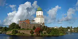
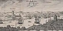
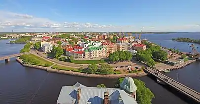 A view of Vyborg from the castle tower | |
 Flag  Coat of arms | |
Location of Vyborg 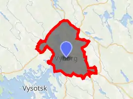
| |
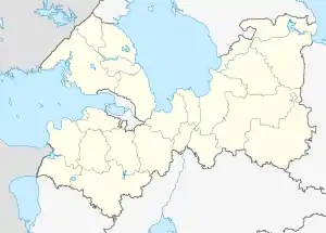 Vyborg Location of Vyborg .svg.png.webp) Vyborg Vyborg (European Russia) 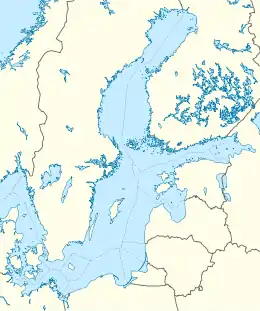 Vyborg Vyborg (Baltic Sea) Vyborg Vyborg (Europe) | |
| Coordinates: 60°43′N 28°46′E | |
| Country | Russia |
| Federal subject | Leningrad Oblast[1] |
| Administrative district | Vyborgsky District[1] |
| Settlement municipal formation | Vyborgskoye Settlement Municipal Formation[1] |
| Founded | 1403 |
| Government | |
| • Body | Council of Deputies[2] |
| • Head[2] | Gennady Orlov[3] |
| Elevation | 3 m (10 ft) |
| Population | |
| • Total | 79,962 |
| • Estimate (2018)[5] | 77,400 (−3.2%) |
| • Rank | 208th in 2010 |
| • Capital of | Vyborgsky District[1], Vyborgskoye Settlement Municipal Formation[1] |
| • Municipal district | Vyborgsky Municipal District[6] |
| • Urban settlement | Vyborgskoye Urban Settlement[6] |
| • Capital of | Vyborgsky Municipal District[6], Vyborgskoye Urban Settlement[6] |
| Time zone | UTC+3 (MSK |
| Postal code(s)[8] | 188800–188802, 188804, 188805, 188807–188811, 188819, 188899 |
| Dialing code(s) | +7 81378[9] |
| OKTMO ID | 41615101001 |
| Website | www |
Located in the boundary zone between the East Slavic/Russian and Finnish worlds, formerly well known as one of the few medieval towns in Finland, Vyborg has changed hands several times in history, most recently in 1944 when the Soviet Union captured it from Finland during World War II.
The city hosts the Russian end of the 1,222 km (759 mi) Nord Stream gas pipeline, laid in 2011 and operated by a consortium led by Russia's Gazprom state hydrocarbons enterprise to pump 55 billion cubic meters (1.9 trillion cubic feet) of natural gas a year under the Baltic to Greifswald, Germany.[14]
History
According to archeological research, the area of what is now Vyborg used to be a trading center on the Vuoksi River's western branch, which has since dried up. The region was inhabited by the Karelians, a Balto-Finnic tribe which gradually came under the domination of Novgorod and Sweden.[15][16] It's been claimed that Vyborg appeared in the 11th–12th centuries as a mixed Karelian-Russian settlement,[17] although there isn't archeological proof of any East Slavic settlement of that time in the area[18] and it isn't mentioned in any earliest historical documents, such as the Novgorod First Chronicle or the Primary Chronicle. Wider settlement in the area of Vyborg is generally regarded to date from 13th century onwards when Hanseatic traders began traveling to Novgorod.[19]
The Vyborg Castle was founded during the Third Swedish Crusade in 1293 by marsk Torkel Knutsson[17] on the site of an older Karelian fort which was burned.[20] The castle, which was the first center for the spread of Christianity in Karelia,[21] was fought over for decades between Sweden and the Novgorod Republic. As a result of the Treaty of Nöteborg in 1323 between the Republic of Novgorod and Sweden, Vyborg was finally recognized as a part of Sweden. The town's trade privileges were chartered by the Pan-Scandinavian King Eric of Pomerania in 1403. It withstood a prolonged siege by Daniil Shchenya during the Russo–Swedish War of 1496–1497.
Under Swedish rule, Vyborg was closely associated with the noble family of Bååt, originally from Småland. The late-medieval commanders and fief holders of Vyborg were (almost always) descended from or married to the Bååt family. In practice, though not having this as their formal title, they functioned as Margraves, had feudal privileges, and kept all the crown's incomes from the fief to use for the defense of the realm's eastern border.
Vyborg remained in Swedish hands until its capture in 1710 after the Siege of Vyborg by Tsar Peter the Great in the Great Northern War.[17] In the course of Peter's second administrative reform, Vyborg became the seat of the Vyborg Province of St. Petersburg Governorate.[22] The 1721 Treaty of Nystad, which concluded the war with Sweden, finalized the transfer of the town and a part of Old Finland to Russia.[17] The loss of Vyborg led Sweden to develop Fredrikshamn as a substitute port town.[23] Another result of the loss of Vyborg was that its diocese was moved to Borgå, transforming the town into an important learning centre.[23]
In 1744, Vyborg became the seat of the Vyborg Governorate.[22] In 1783, the governorate was transformed into the Vyborg Viceroyalty,[22] then in 1801 back into Vyborg Governorate. In 1802, the Vyborg Governorate was renamed the Finland Governorate.[22]
One of the largest naval battles in history, the Battle of Vyborg Bay, was fought off the shore of the Vyborg Bay on July 4, 1790.
After the rest of Finland was ceded to Russia in 1809, Emperor Alexander I incorporated the town and the governorate into the newly created Grand Duchy of Finland in 1811 (1812 NS).[24]
In the course of the 19th century, the town developed as the center of administration and trade for the eastern part of Finland. The inauguration of the Saimaa Canal in 1856 benefited the local economy as it opened the vast waterways of Eastern Finland to the sea. Vyborg was never a major industrial center and lacked large production facilities, but due to its location it served as a focal point of transports of all industries on the Karelian Isthmus, Ladoga Karelia, and southeastern Finland.
Bolshevik revolutionary Vladimir Lenin lived in the town for a period between the February Revolution and October Revolution of 1917.
Following the Russian Revolution of 1917 and the fall of the Russian Empire, Finland declared itself independent. During the Finnish Civil War, Vyborg was in the hands of the Finnish Red Guards until it was captured by the White Guard on the Battle of Vyborg, April 29, 1918. In April–May 1918, 360–420 civilians were murdered by White Guards during the Vyborg massacre.
In the inter-war decades, the town was the fourth largest town in Finland and the seat of the Viipuri Province. In 1939, Vyborg had roughly 80,000 inhabitants, including sizable minorities of Swedes, Germans, Russians, Romani, Tatars, and Jews. During this time, Alvar Aalto built the Vyborg Library—an icon of functionalist architecture.
Winter and Continuation wars
During the Winter War between the Soviet Union and Finland in 1939–1940, over seventy thousand people were evacuated from Vyborg to other parts of Finland. The Winter War was concluded by the Moscow Peace Treaty, which stipulated the transfer of Vyborg and the whole Karelian Isthmus—emptied of their residents—to Soviet control, where it was incorporated into the Karelo-Finnish Soviet Socialist Republic on March 31, 1940. As the town was still held by the Finns, the remaining Finnish population, some ten thousand people, had to be evacuated in haste before the handover. Thus, practically the whole population of Finnish Vyborg was resettled elsewhere in Finland. The town became the administrative center of Vyborgsky District.
The evacuees from Finnish Karelia came to be a vociferous political force and their wish to return to their homes was an important motive when Finland sought support from Nazi Germany against the Soviet threat. As a result, Finland and Nazi Germany fought on the same side in the Continuation War.
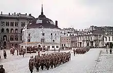
On August 29, 1941, Vyborg was captured by Finnish troops. At first, the Finnish Army did not allow civilians into the town. Of the 6,287 buildings, 3,807 had been destroyed. The first civilians started to arrive at the end of September and by the end of the year Vyborg had a population of about 9,700. In December 1941, the Government of Finland formally annexed the town along with the other areas lost in the Moscow Peace Treaty. However, this annexation was not recognized by any foreign state, not even Finland's co-belligerent, Germany. By 1942, it had risen to 16,000. About 70% of the evacuees from Finnish Karelia returned after the re-conquest to rebuild their looted homes, but were again evacuated after the Red Army's Vyborg–Petrozavodsk Offensive, timed to coincide with the Battle of Normandy. By the time of the Soviet offensive, the town had a population of nearly 28,000. The town was evacuated by June 19 and the defense of Vyborg was entrusted to the 20th Brigade. The town fell to the Red Army on June 20, 1944, but the Finns managed to halt the Soviet offensive at the Battle of Tali-Ihantala—the largest battle fought by any of the Nordic countries—in Viipuri rural municipality which surrounded the town. The town was seriously damaged.
In the subsequent Moscow Armistice of September 19, 1944, Finland returned to the borders set by the Moscow Peace Treaty and ceded more land than the treaty originally demanded. In the 1947 Paris Peace treaties, Finland relinquished all claims to Vyborg.
After the Winter War, Leningrad Oblast wanted to incorporate the area of Vyborg, but it took until November 1944 for it to be finally transferred from the Karelo-Finnish SSR.[24] During the Soviet era, the town was settled by people from all over the Soviet Union. The naval air bases of Pribilovo and Veshchevo were built nearby.
Administrative and municipal status
Within the framework of administrative divisions, Vyborg serves as the administrative center of Vyborgsky District.[1] As an administrative division, it is incorporated within Vyborgsky District as Vyborgskoye Settlement Municipal Formation.[1] As a municipal division, Vyborgskoye Settlement Municipal Formation is incorporated within Vyborg Municipal District as Vyborgskoye Urban Settlement.[6]
Climate
Similar to many other areas along the Baltic Sea, Vyborg has a humid continental climate[25] (Dfb) with large temperature differences between summer and winter but too mild to be classified subarctic with five months above 10 °C (50 °F) in mean temperature. Winter temperatures are being somewhat moderated by maritime effects compared to Russian cities further inland even on more southerly latitudes, but still cold enough to be comparable to areas much further north that are nearer the Gulf Stream.
| Climate data for Vyborg | |||||||||||||
|---|---|---|---|---|---|---|---|---|---|---|---|---|---|
| Month | Jan | Feb | Mar | Apr | May | Jun | Jul | Aug | Sep | Oct | Nov | Dec | Year |
| Record high °C (°F) | 6.5 (43.7) |
10.0 (50.0) |
13.8 (56.8) |
22.1 (71.8) |
29.0 (84.2) |
32.9 (91.2) |
34.6 (94.3) |
33.4 (92.1) |
29.0 (84.2) |
19.0 (66.2) |
11.1 (52.0) |
8.4 (47.1) |
34.6 (94.3) |
| Average high °C (°F) | −4.0 (24.8) |
−4.1 (24.6) |
0.5 (32.9) |
7.2 (45.0) |
14.7 (58.5) |
19.2 (66.6) |
22.3 (72.1) |
20.2 (68.4) |
14.3 (57.7) |
7.9 (46.2) |
1.7 (35.1) |
−2.1 (28.2) |
8.2 (46.8) |
| Daily mean °C (°F) | −6.7 (19.9) |
−7.3 (18.9) |
−3.0 (26.6) |
3.0 (37.4) |
10.2 (50.4) |
15.0 (59.0) |
18.2 (64.8) |
16.3 (61.3) |
10.9 (51.6) |
5.5 (41.9) |
−0.4 (31.3) |
−4.5 (23.9) |
4.8 (40.6) |
| Average low °C (°F) | −9.5 (14.9) |
−10.5 (13.1) |
−6.4 (20.5) |
−0.5 (31.1) |
5.9 (42.6) |
11.1 (52.0) |
14.3 (57.7) |
12.7 (54.9) |
7.9 (46.2) |
3.2 (37.8) |
−2.3 (27.9) |
−7.1 (19.2) |
1.6 (34.9) |
| Record low °C (°F) | −36.8 (−34.2) |
−34.0 (−29.2) |
−29.0 (−20.2) |
−20.0 (−4.0) |
−5.0 (23.0) |
0.0 (32.0) |
5.8 (42.4) |
0.0 (32.0) |
−4.0 (24.8) |
−11.4 (11.5) |
−19.8 (−3.6) |
−34.0 (−29.2) |
−36.8 (−34.2) |
| Average precipitation mm (inches) | 48 (1.9) |
36 (1.4) |
40 (1.6) |
31 (1.2) |
40 (1.6) |
63 (2.5) |
65 (2.6) |
82 (3.2) |
68 (2.7) |
76 (3.0) |
67 (2.6) |
61 (2.4) |
677 (26.7) |
| Average rainy days | 6 | 5 | 7 | 10 | 14 | 15 | 15 | 15 | 17 | 17 | 13 | 9 | 143 |
| Average snowy days | 17 | 15 | 12 | 5 | 0 | 0 | 0 | 0 | 0 | 2 | 9 | 16 | 76 |
| Average relative humidity (%) | 87 | 85 | 82 | 74 | 68 | 71 | 73 | 77 | 82 | 86 | 88 | 89 | 80 |
| Source: Pogoda.ru.net[26] | |||||||||||||
Economy and culture
Vyborg continues to be an important industrial producer of paper. Tourism is increasingly important, and the Russian film festival Window to Europe takes place in the town each year.
An HVDC back-to-back facility for the exchange of electricity between the Russian and Finnish power grids was completed near Vyborg in 1982. It consists of three bipolar HVDC back-to-back schemes with an operating voltage of 85 kV and a maximum transmission rate of 355 MW, so that the entire maximum transmission rate amounts to 1,420 MW.
The Nord Stream offshore pipeline runs from Vyborg compressor station at Portovaya Bay along the bottom of the Baltic Sea to Greifswald in Germany. It started operating in September 2011, enabling Russia to export gas directly to Western Europe, bypassing states between Russia and Germany that could profit from transit fees and interfere in operations. The feeding pipeline in Russia (Gryazovets–Vyborg gas pipeline) is operated by Gazprom and is a part of the integrated gas transport network of Russia connecting existing grid in Gryazovets with the coastal compressor station at Vyborg.[27]
Sights
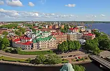
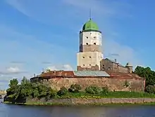
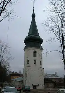
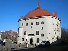
Vyborg's most prominent landmark is its Swedish-built castle, started in the 13th century and extensively reconstructed in 1891–1894. The Round Tower and the Rathaus Tower date from the mid-16th century and are parts of the Medieval Vyborg town wall. The Viipuri Library by Finnish architect Alvar Aalto and the Hermitage-Vyborg Center are a reference point in the history of modern architecture.
There are also Russian fortifications of Annenkrone, completed by 1740, as well as the monuments to Peter the Great (1910) and Torkel Knutsson. Tourists can also visit the house where the founder of the Soviet state Vladimir Lenin prepared the Bolshevik revolution during his stay in Viipuri from September 24 to October 7, 1917.
Sprawling along the heights adjacent to the Gulf of Finland is Monrepos Park, one of the most spacious English landscape gardens in Eastern Europe. The garden was laid out on behest of its owner, Baron Ludwig Heinrich von Nicolay, at the turn of the 19th century. Most of its structures were designed by the architect Giuseppe Antonio Martinelli. Previously, the estate belonged to the future king Frederick I (Maria Fyodorovna's brother), who called it Charlottendahl in honor of his second wife.
Notable people
Born before 1917
for people born in Viipuri Province between 1812 and 1917, when it was part of the Grand Duchy of Finland.
Born 1917–1945
.jpg.webp)
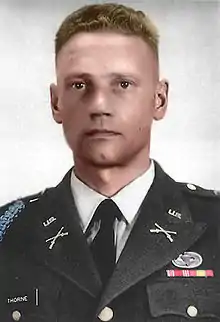
- Lauri Törni (1919–1965), a Finnish Army captain who later served in the German and United States armies
- Sirkka Sari (1920 in Raivola – 1939), a Finnish actress
- Lars Lindeman (1920–2006), a Finnish politician and ambassador in Oslo, Reykjavik, and Lisbon
- Pekka Malinen (1921–2004), minister and diplomat, ambassador in Egypt, Syria, and Portugal
- Paul Jyrkänkallio (1922 in Koivisto – 2004), a Finnish diplomat, ambassador in Sofia, Rome, and Athens
- Usko Santavuori (1922 in Viipuri – 2003), a Finnish sensationalist radio reporter
- Max Jakobson (1923–2013), a Finnish diplomat and journalist of Finnish-Jewish descent
- Tankmar Horn (1924–2018), a Finnish diplomat, economist, and businessman.
- Heimo Haitto (1925–1999), a Finnish-American classical violinist and child prodigy
- Juhani Kumpulainen (1925 in Viipuri – 1991), a Finnish actor and director
- Seppo Pietinen (1925–1990), a Finnish diplomat, Ambassador in Addis Ababa, Lima, Vienna, and Paris
- Ilmi Parkkari (1926–1979), a Finnish film and stage actress
- Erik Bruun (born 1926 in Viipuri), a Finnish graphic designer
- Ossi Runne (1927 - 2020), a Finnish musician
- Heikki Seppä (1927 in Säkkijärvi – 2010), a Finnish-American master metalsmith, educator and author
- Veijo Meri (1928–2015), a Finnish writer, his work focuses on war and its absurdity
- Casper Wrede (1929 in Viipuri – 1998), a Finnish theatre and film director
- Esko Kunnamo (1929–2014), a Finnish diplomat, ambassador in Kuwait, Abu Dhabi & Lagos
- Paavo Rintala (1930–1999), a Finnish novelist and theologian
- Pertti Ripatti (1930–2016), a Finnish diplomat, ambassador in Abu Dhabi, Caracas & Kuala Lumpur
- Oiva Toikka (1931–2019), a Finnish glass designer
- Lasse Äikäs (1932 in Kuolemajärvi – 1988), a Finnish lawyer, civil servant and politician
- Kari Nurmela (Viipuri 1933 – 1984), a Finnish dramatic baritone
- Pertti Kärkkäinen (1933–2017), a Finnish diplomat, Ambassador to Buenos Aires, Santiago & Lima
- Pentti Ikonen (1934–2007), a Finnish swimmer, competed in 3 events at the 1952 Summer Olympics
- Martti Ahtisaari (born 1937 in Viipuri), a Finnish politician, the tenth President of Finland (1994–2000) and Nobel Peace Prize laureate
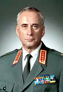
- Gustav Hägglund (born 1938 in Viipuri), a retired Finnish general, Chief of Defence 1994–2001
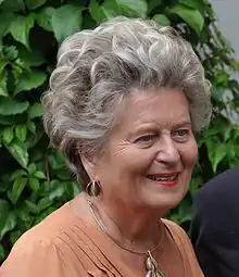
- Laila Hirvisaari (born 1938 in Viipuri), a Finnish author and writer
- Heikki Talvitie (born 1939), a Finnish diplomat, Ambassador in Belgrade, Moscow & Stockholm
- Riitta Uosukainen (born 1942 in Jääski), a Finnish politician and former MP, Counselor of State

Born after 1945
- Negmatullo Kurbanov (born 1963), a Tajik major general in the Ministry of Internal Affairs (Tajikistan)
- Viatcheslav Ekimov (born 1966), nicknamed Eki, a Russian former professional racing cyclist and triple Olympic gold medalist
- Vitaly Petrov (born 1984), a Russian racing driver who drove in Formula One for Renault F1 Team in 2010
- Aleksei Kangaskolkka (born 1988), a Russian-born Finnish footballer, who plays for Finnish side IFK Mariehamn
- Kirill Alekseenko (born 1997), a Russian chess grandmaster, participant in the Candidates Tournament 2020
References
Notes
- Oblast Law #32-oz
- Charter of Vyborgskoye Urban Settlement, Article 1
- Official website of Vyborgskoye Urban Settlement. Head of the Municipal Formation, Gennady Vasilyevich Orlov (in Russian)
- Russian Federal State Statistics Service (2011). "Всероссийская перепись населения 2010 года. Том 1" [2010 All-Russian Population Census, vol. 1]. Всероссийская перепись населения 2010 года [2010 All-Russia Population Census] (in Russian). Federal State Statistics Service.
- "26. Численность постоянного населения Российской Федерации по муниципальным образованиям на 1 января 2018 года". Federal State Statistics Service. Retrieved January 23, 2019.
- Law #17-oz
- "Об исчислении времени". Официальный интернет-портал правовой информации (in Russian). June 3, 2011. Retrieved January 19, 2019.
- Почта России. Информационно-вычислительный центр ОАСУ РПО. (Russian Post). Поиск объектов почтовой связи (Postal Objects Search) (in Russian)
- Ленинградская область (in Russian). ruspostindex.ru. Retrieved March 20, 2014.
- Wuorinen, John H. (1948), ed., Finland and World War II, 1939-1944, New York: Roland Press, p. 172.
- Russian Federal State Statistics Service (May 21, 2004). "Численность населения России, субъектов Российской Федерации в составе федеральных округов, районов, городских поселений, сельских населённых пунктов – районных центров и сельских населённых пунктов с населением 3 тысячи и более человек" [Population of Russia, Its Federal Districts, Federal Subjects, Districts, Urban Localities, Rural Localities—Administrative Centers, and Rural Localities with Population of Over 3,000] (XLS). Всероссийская перепись населения 2002 года [All-Russia Population Census of 2002] (in Russian).
- "Всесоюзная перепись населения 1989 г. Численность наличного населения союзных и автономных республик, автономных областей и округов, краёв, областей, районов, городских поселений и сёл-райцентров" [All Union Population Census of 1989: Present Population of Union and Autonomous Republics, Autonomous Oblasts and Okrugs, Krais, Oblasts, Districts, Urban Settlements, and Villages Serving as District Administrative Centers]. Всесоюзная перепись населения 1989 года [All-Union Population Census of 1989] (in Russian). Институт демографии Национального исследовательского университета: Высшая школа экономики [Institute of Demography at the National Research University: Higher School of Economics]. 1989 – via Demoscope Weekly.
- The Pipeline, Nord Stream AG official website, Undated. Accessed: 14 June 2014.
- Jussi Katajala (2010). "Suomen kaupungit keskiajalla" (in Finnish). Retrieved February 12, 2016.
- Uino, Pirjo (1997). Ancient Karelia. Helsinki: Suomen muinaismuistoyhdistyksen aikakausikirja 104. p. 115.
- Энциклопедия Города России. Moscow: Большая Российская Энциклопедия. 2003. p. 95. ISBN 5-7107-7399-9.
- Uino, Pirjo (1997). Ancient Karelia. Helsinki: Suomen muinaismuistoyhdistyksen aikakausikirja 104. pp. 343–346.
- Uino, Pirjo (1997). Ancient Karelia. Helsinki: Suomen muinaismuistoyhdistyksen aikakausikirja 104. p. 118.
- Taavitsainen, Jussi-Pekka (1990). Ancient Hillforts of Finland. Suomen muinaismuistoyhdistyksen aikakausikirja 94. p. 240.
- Chisholm 1911.
- С. А. Тархов (2001). "Изменение административно-территориального деления России за последние 300 лет". Электронная версия журнала "География".
- Lindberg, Johan (May 26, 2016). "Finlands historia: 1700-talet". Uppslagsverket Finland (in Swedish). Retrieved November 30, 2017.
- История Выборгского района, история Выборгской земли (in Russian). Муниципальное образование Выборгский район Ленинградской Области. Retrieved March 20, 2014.
- "Vyborg, Russia Climate Summary". Weatherbase. Retrieved January 23, 2015.
- "Climate in Vyborg". Pogoda i Klimat (in Russian). May 2011. Retrieved August 4, 2012.
- "Answers to questions asked by representatives of non-governmental organizations on the EIA procedure for the Nord Stream Project" (PDF). Nord Stream AG. October 20, 2007. Retrieved February 15, 2008.
Sources
- Совет депутатов муниципального образования "Выборгское городское поселение". Решение №63 от 1 июня 2010 г. «Устав муниципального образования "Город Выборг" Выборгского района Ленинградской области». (Council of Deputies of the Municipal Formation of "Vyborgskoye Urban Settlement". Decision #63 of June 1, 2010 Charter of the Municipal Formation of the "Town of Vyborg" of Vyborgsky District of Leningrad Oblast. ).
- Законодательное собрание Ленинградской области. Областной закон №32-оз от 15 июня 2010 г. «Об административно-территориальном устройстве Ленинградской области и порядке его изменения», в ред. Областного закона №23-оз от 8 мая 2014 г. «Об объединении муниципальных образований "Приморское городское поселение" Выборгского района Ленинградской области и "Глебычевское сельское поселение" Выборгского района Ленинградской области и о внесении изменений в отдельные Областные законы». Вступил в силу со дня официального опубликования. Опубликован: "Вести", №112, 23 июня 2010 г. (Legislative Assembly of Leningrad Oblast. Oblast Law #32-oz of June 15, 2010 On the Administrative-Territorial Structure of Leningrad Oblast and on the Procedures for Its Change, as amended by the Oblast Law #23-oz of May 8, 2014 On Merging the Municipal Formations of "Primorskoye Urban Settlement" in Vyborgsky District of Leningrad Oblast and "Glebychevskoye Rural Settlement" in Vyborgsky District of Leningrad Oblast and on Amending Various Oblast Laws. Effective as of the day of the official publication.).
- Законодательное собрание Ленинградской области. Областной закон №17-оз от 10 марта 2004 г. «Об установлении границ и наделении соответствующим статусом муниципальных образований Всеволожский район и Выборгский район и муниципальных образований в их составе», в ред. Областного закона №23-оз от 8 мая 2014 г. «Об объединении муниципальных образований "Приморское городское поселение" Выборгского района Ленинградской области и "Глебычевское сельское поселение" Выборгского района Ленинградской области и о внесении изменений в отдельные Областные законы». Вступил в силу со дня официального опубликования. Опубликован: "Вести", №27, 11 марта 2004 г. (Legislative Assembly of Leningrad Oblast. Oblast Law #17-oz of March 10, 2004 On Establishing the Borders of and Granting an Appropriate Status to the Municipal Formations of Vsevolozhsky District and Vyborgsky District and to the Municipal Formations Comprising It, as amended by the Oblast Law #23-oz of May 8, 2014 On Merging the Municipal Formations of "Primorskoye Urban Settlement" in Vyborgsky District of Leningrad Oblast and "Glebychevskoye Rural Settlement" in Vyborgsky District of Leningrad Oblast and on Amending Various Oblast Laws. Effective as of the day of the official publication.).
External links
| Wikimedia Commons has media related to Vyborg. |
| Wikivoyage has a travel guide for Vyborg. |
- Official website of Vyborg (in Russian)
- History and attractions of Vyborg
- Chisholm, Hugh, ed. (1911). . Encyclopædia Britannica. 28 (11th ed.). Cambridge University Press. p. 17.
| Authority control |
|---|