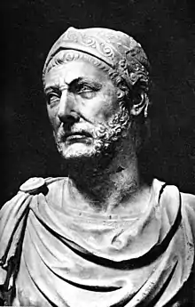
Hanno the Navigator
Hanno the Navigator (sometimes written "Hannon"; Punic: 𐤇𐤍𐤀, ḤNʾ;[1] Greek: Ἄννων Annōn[2]) was a Carthaginian explorer of the fifth century BC,[3] best known for his naval exploration of the western coast of Africa. The only source of his voyage is a Greek periplus. According to some modern analyses of his route, Hanno's expedition could have reached as far south as Gabon; however, others have taken him no further than southern Morocco.[4]
Hanno the Navigator | |
|---|---|
| Nationality | Carthaginian |
| Occupation | Explorer |
| Years active | 5th century BC |
| Known for | Naval exploration of the western coast of Africa |
Works | A periplus about his journey |
Biography
The name Hanno was given to many other Carthaginians. Ancient authors who discussed Hanno did not provide direct information to identify the exact person named Hanno. Some called him king, and others used the Latin words dux (leader or general) or imperator (commander or emperor).[5]
According to Brian Herbert Warmington, writing in 1960, the consensus of scholarship is that Hanno lived in the fifth century BC and was a member of the aristocratic Magonid family.[6]
Periplus account
A Greek text, supposedly Hanno's report, remains extant.[7] While it contains contradictions and obvious errors,[8] it is likely derived from an original Carthaginian text.[6] According to Hugh Murray, the periplus is the sole survivor of systematic Roman destruction of Carthaginian texts.[9] Warmington writes that it is "the nearest we have to a specimen of Carthaginian 'literature'."[6]
Both ancient and modern authors have criticized the work. Most attempts to locate the places described in the periplus based on the reported sailing distances and directions have failed.[8] To make the text more accurate, scholars have tried textual criticism. Ultimately, the Carthaginians probably edited the real account to protect their trade: other countries would not be able to identify the places described, while Carthaginians could still boast about their accomplishments.[8]
In the fifth century, the text was translated into a rather mediocre Greek. It was not a complete rendering; several abridgments were made. The abridged translation was copied several times by Greek and Greek-speaking Roman clerks. Currently, there are only two copies, dating back to the ninth and the fourteenth centuries.[10]
The first of these manuscripts is known as the Palatinus Graecus 398 and can be studied in the University Library of Heidelberg.[11] The other text is in the Codex Vatopedinus 655, found in the Vatopedi monastery in Mount Athos, Greece, and dated to the beginning of the 14th century; the codex is divided between the British Library[12] and the French Bibliothèque Nationale.
Ancient authors' accounts
The text was known to Pliny the Elder and Arrian of Nicomedia.
Pliny the Elder
While the power of Carthage was at its height, Hanno published an account of a voyage which he made from Gades [modern Cádiz] to the extremity of Arabia; Himilco was also sent, about the same time, to explore the remote parts of Europe.
Pliny may have recorded the time vaguely because he was ignorant of the actual date.[7]
Arrian
Arrian mentions Hanno's voyage at the end of his Anabasis of Alexander VIII (Indica):
Hannon the Libyan set out from Carthage with Libya on his left and sailed out beyond the Pillars of Heracles into the Outer Sea, continuing his voyage then in an easterly direction for a total of thirty-five days: but when he eventually turned south he met a number of crippling obstacles—lack of water, burning heat, streams of lava gushing into the sea.
Expedition
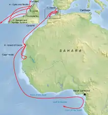
Carthage dispatched Hanno at the head of a fleet of 60 ships to explore and colonize the northwestern coast of Africa.[16] He sailed through the straits of Gibraltar, founded or repopulated seven colonies along the African coast of what is now Morocco, and explored significantly farther along the Atlantic coast of the continent. Hanno encountered various indigenous peoples on his journey and met with a variety of welcomes.
The gold trade was a foundation of the Carthaginian empire since the fifth century BC. It may have been the original motivation for Carthaginian exploration of sub-Saharan Africa.[7] The purpose of Hanno's voyage was to secure the gold route to west Africa.[8]
Gorillai
At the terminus of Hanno's voyage, the explorer found an island heavily populated with what were described as hirsute (hairy) and savage people. Attempts to capture the men failed, but three of the women were taken. These were so ferocious that they were killed, and their skins preserved for transport home to Carthage. The skins were kept in the Temple of Juno (Tanit or Astarte) on Hanno's return and, according to Pliny the Elder, survived until the Roman destruction of Carthage in 146 BC, some 350 years after Hanno's expedition.[10][17] The interpreters travelling with Hanno called the people Gorillai (in the Greek text Γόριλλαι).
[W]e arrived at a bay called HORN OF THE SOUTH. And in this bay was an island which looked like the first, having a lake and in it another island filled with wild savages. The biggest number of them were females, with hairy bodies, which our [Lixitae] [prior brackets in original; also called the Nasamonians, a Libyan tribe] interpreters called "Gorillas". Chasing them, we could not catch any of the males, because all of them escaped by being able to climb steep cliffs and defending themselves with whatever was available; but we caught three females who bit and scratched their captors and they did not want to follow them. So we had to kill them and flayed them and we brought their skins to Carthage[.]
— Hanno, Periplus 88–99[18]
Thomas S. Savage and Jeffries Wyman, who described gorillas in the 19th century, named the species Troglodytes gorilla. They thought that the Gorillai were a species of ape.[19]
Modern analysis
A number of modern scholars have commented upon Hanno's voyage. In many cases, the analysis has been to refine information and interpretation of the original account. William Smith points out that the complement of personnel totalled 30,000, and that the core mission included the intent to found Carthaginian (or in the older parlance 'Libyophoenician') towns.[20] Some scholars have questioned whether this many people accompanied Hanno on his expedition, and suggest 5,000 is a more accurate number.[10] R. C. C. Law notes that "It is a measure of the obscurity of the problem that while some commentators have argued that Hanno reached the Gabon area, others have taken him no further than southern Morocco."[4]
Harden reports a general consensus that the expedition reached at least as far as Senegal.[21] Due to the vagueness of the periplus, estimates for the voyage's distance range from under 700 miles (1,100 km) to at least 3,000 miles (4,800 km).[22] Some agree he could have reached Gambia. However, Harden mentions disagreement as to the farthest limit of Hanno's explorations: Sierra Leone, Cameroon, or Gabon. He notes the description of Mount Cameroon, a 4,040-metre (13,250 ft) volcano, more closely matches Hanno's description than Guinea's 890-metre (2,920 ft) Mount Kakulima. Warmington prefers Mount Kakulima, considering Mount Cameroon too distant.[23]
The historian Raymond Mauny, in his 1955 article "La navigation sur les côtes du Sahara pendant l'antiquité", argued that the ancient navigators (Hannon, Euthymène, Scylax, etc.) could not have sailed south in the Atlantic farther than Cape Bojador. He pointed out that antique geographers knew of the Canary Islands but nothing further south. Ships with square sails, without stern rudder, might navigate south, but the winds and currents throughout the year would prevent the return trip from Senegal to Morocco. Oared ships might be able to achieve the return northward, but only with very great difficulties. Mauny assumed that Hanno did not get farther than the Drâa. He attributed artifacts found on Mogador Island to the expedition described in the Periplus of Pseudo-Scylax and notes that no evidence of Mediterranean trade further south had yet been found. The author ends by suggesting archaeological investigation of the islands along the coast, such as Cape Verde, or the île de Herné (Dragon Island near Dakhla, Western Sahara) where ancient adventurers may have been stranded and settled.[24]
Popular culture
- The lunar crater Hanno is named after him.[25]
- Hanno was a subject of the second episode of the History Channel documentary Mankind: The Story of All of Us.
- Hanno is the subject of the song "Hanno the Navigator" by Al Stewart from his album Sparks of Ancient Light.
- Hanno is a central figure in Poul Anderson's science fiction novel The Boat of a Million Years.
References
Citations
- Huss 1985, p. 565
- "Ἄννων". Logeion. University of Chicago. Retrieved October 29, 2020.
- Law 1978, p. 134
- Law 1978, p. 135
- Schmitz 1847, p. 346
- Warmington 1960, p. 62
- Warmington 1960, p. 61
- Warmington 1960, p. 64
- Murray 1844, p. 11
- Hanno; Lendering, Jona (1998). "Hanno the Navigator". livius.org. Translated by Lendering, Jona. Retrieved 29 October 2020.
- "Universitätsbibliothek Heidelberg, Cod. Pal. graec. 398" [Heidelberg University Library, Codex Palatinus Graecus 398]. Heidelberg University Library. University of Heidelberg. September 5, 2008. Retrieved 30 October 2020.
- "Add MS 19391". British Library. Retrieved 30 October 2020.
- Pliny the Elder 1855, Book 2 Chapter 7
- Arrian 2013, p. 265
- Herodotus 1920, 4.196
- Warmington 1960, pp. 74–76
- Hoyos 2010, p. 53
- Hanno 1977, p. 29
- Savage & Wyman 1847, pp. 419–420
- Schmitz 1867, p. 346
- Harden 1963, p. 168
- Murray 1844, p. 12
- Warmington 1960, p. 79
- Mauny 1955
- "Planetary Names: Crater, craters: Hanno on Moon". Gazetteer of Planetary Nomenclature. International Astronomical Union, United States Geological Survey, and National Aeronautics and Space Administration. Retrieved October 31, 2020.
Bibliography
- Arrian (2013). Alexander the Great: The Anabasis and the Indica. Translated by Hammond, Martin. Oxford World's Classics. ISBN 978-0-19-958724-7.
- Hanno (1977). Periplus, or Circumnavigation (of Africa). Translated by Oikonomides, Al. N. (2nd ed.). Chicago: Ares Publishers. ISBN 978-0-89005-217-4.
- Harden, Donald Benjamin (1963) [1962]. Daniel, Glyn (ed.). The Phoenicians. Ancient Peoples and Places (2nd ed.). New York: Frederick A. Praeger.
- Herodotus. Herodotus, With an English Translation. Translated by Godley, Alfred Denis. Cambridge, Massachusetts: Harvard University Press – via Perseus Digital Library.
- Hoyos, Dexter (2010). The Carthaginians. Routledge. ISBN 978-0-415-43645-8.
- Huss, Werner (1985). Geschichte der Karthager [History of the Carthaginians]. Handbuch der Altertumswissenschaft (in German). Munich: C.H. Beck. ISBN 978-3-406-30654-9.
- Law, R. C. C. (1978). "North Africa in the period of Phoenician and Greek colonization, c. 800 to 325 BC". In Fage, John Donnelly; Oliver, Roland Anthony (eds.). The Cambridge History of Africa. 2. Cambridge University Press. pp. 87–147. ISBN 978-0-521-21592-3.
- Mauny, Raymond (1955). "La navigation sur les côtes du sahara pendant l'antiquité" [The Navigation on the Coasts of the Sahara during Antiquity]. Revue des Études Anciennes (in French). Bordeaux Montaigne University. 57 (1): 92–101. doi:10.3406/rea.1955.3523.
- Murray, Hugh (1844). An Encyclopædia of Geography (2nd ed.). London: Longman, Brown, Green, and Longmans.
- Pliny the Elder (1855). The Natural History. Translated by Bostock, John; Riley, Henry Thomas. London: Taylor and Francis – via Perseus Digital Library.
- Savage, Thomas Staughton; Wyman, Jeffries (December 1847). "Notice of the External Characters and Habits of Troglodytes gorilla, a New Species of Orang from the Gaboon River". Boston Journal of Natural History. Boston Society of Natural History. 5 (4): 417–442.
- Schmitz, Leonhard (1867). "Hanno". In Smith, William (ed.). Dictionary of Greek and Roman Biography and Mythology. 2. Boston: Little, Brown, and Company. pp. 346–347.
- Warmington, Brian Herbert (1960). Carthage. New York: Frederick A. Praeger.
Further reading
- Bunbury, Edward Herbert (1879). A History of Ancient Geography Among the Greeks and Romans: From the Earliest Ages till the Fall of the Roman Empire. London: John Murray.
- Carpenter, Rhys (1966). Nef, Evelyn Stefansson (ed.). Beyond the Pillars of Heracles: The Classical World Seen through the Eyes of its Discoverers. The Great Explorers. New York: Delacorte Press. OCLC 497693.
- Cary, Max; Warmington, Eric Herbert (1929). The Ancient Explorers. London: Methuen & Co.
- Hyde, Walter Woodburn (1947). Ancient Greek Mariners. New York: Oxford University Press. OCLC 729151140.
- Kaeppel, Carl (1936). Off the Beaten Track in the Classics. New York: Melbourne University Press. OCLC 251153057.
- Thomson, James Oliver (2013) [1948]. History of Ancient Geography. Cambridge: Cambridge University Press. ISBN 978-1-107-68992-3.
External links
| Greek Wikisource has original text related to this article: |
- Works by Hanno the Navigator at LibriVox (public domain audiobooks)

- "Hanno's Periplus on the Web"—a 2003 directory of links about Hanno
- "The Voyage of Hanno"—an article by classical scholar Livio Catullo Stecchini that analyzes parts of Hanno's periplus
| Authority control |
|---|