Haram, Norway
Haram is a former municipality in Møre og Romsdal county, Norway. It was part of the Sunnmøre region. The administrative center was Brattvåg, the industrial center of Sunnmøre. Other important villages in the municipality included Austnes, Eidsvik, Helle, Longva, Hildrestranda, Søvik, Tennfjord, and Vatne.
Haram kommune | |
|---|---|
 View of Lepsøy | |
 Coat of arms  Møre og Romsdal within Norway | |
 Haram within Møre og Romsdal | |
| Coordinates: 62°34′03″N 06°22′20″E | |
| Country | Norway |
| County | Møre og Romsdal |
| District | Sunnmøre |
| Established | 1 Jan 1838 |
| Disestablished | 1 Jan 2020 |
| Administrative centre | Brattvåg |
| Government | |
| • Mayor (2015-2019) | Vebjørn Krogsæter (Sp) |
| Area | |
| • Total | 261.14 km2 (100.83 sq mi) |
| • Land | 254.30 km2 (98.19 sq mi) |
| • Water | 6.84 km2 (2.64 sq mi) 2.6% |
| Area rank | 294 in Norway |
| *Area at municipal dissolution. | |
| Population (2018) | |
| • Total | 9,345 |
| • Rank | 122 in Norway |
| • Density | 36.7/km2 (95/sq mi) |
| • Change (10 years) | 8.4% |
| Demonym(s) | Harams-mann Harams-kvinne Haramsøying[1] |
| Time zone | UTC+01:00 (CET) |
| • Summer (DST) | UTC+02:00 (CEST) |
| ISO 3166 code | NO-1534 |
| Official language form | Nynorsk[2] |
| Created as | Formannskapsdistrikt in 1838 |
| Succeeded by | Ålesund in 2020 |
| Website | haram |
Brattvåg IL is a sports club based in the municipality. Tennfjord Mannskor is a male choir from the village of Tennfjord. The Ulla Lighthouse and Hellevik Lighthouse are both located in the northwestern part of the municipality.
At the time if its dissolution in 2020, the 261-square-kilometre (101 sq mi) municipality is the 294th largest by area out of the 422 municipalities in Norway. Haram is the 122nd most populous municipality in Norway with a population of 9,345. The municipality's population density is 36.7 inhabitants per square kilometre (95/sq mi) and its population has increased by 8.4% over the last decade.[3][4]
General information

The parish of Haram was established as a municipality on 1 January 1838 (see formannskapsdistrikt law). The western island district of Roald was separated from Haram on 1 January 1890 to form the new municipality of Roald. This left 1,956 people left in Haram.
During the 1960s, there were many municipal mergers across Norway due to the work of the Schei Committee. On 1 January 1965, three municipal changes involving Haram occurred:
- The part of Haram Municipality on the island of Harøya, including the Myklebost area and the smaller surrounding islands to the west of there (population: 287), was separated from Haram Municipality and merged into the neighboring Sandøy Municipality to the northeast.
- Most of Vatne Municipality (population: 2,260) to the southeast of Haram Municipality was merged into Haram Municipality.
- The Søvik area in Borgund Municipality (population: 1,191) to the south of Haram Municipality were merged into Haram.
These three boundary changes created a much larger municipality of Haram.[5]
On 1 January 2020, the neighboring municipalities of Haram, Skodje, Ørskog, Sandøy, and Ålesund were merged to form a new, large municipality of Ålesund. This occurred because in June 2017, the Parliament of Norway voted to approve the merger.[6]
Name
The municipality (originally the parish) is named after the old Haram farm (Old Norse: Harhamarr), since the first Haram Church was built there. The meaning of the first element is unknown and the last element is hamarr which means "rocky hill". Before 1889, the name was written Harham.[7]
Coat of arms
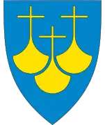
The coat of arms was granted on 7 August 1987. The arms show three waves in blue with a silver or white background, symbolizing the importance of the sea in this island municipality.[8]
Dialect
The dialect of the district was well known for its practice of H-dropping and the old and traditional pronunciation of the name of the municipality was [a:ram].
Churches
The Church of Norway has five parishes (sokn) within the municipality of Haram. It is part of the Nordre Sunnmøre prosti (deanery) in the Diocese of Møre.
| Parish (sokn) | Church name | Location of the church | Year built |
|---|---|---|---|
| Haram | Haram Church | Austnes | 1838 |
| Lepsøy Chapel | Lepsøya | 1896 | |
| Fjørtoft | Fjørtoft Church | Fjørtofta | 1878 |
| Vatne | Vatne Church | Vatne | 1868 |
| Hamnsund | Hamnsund Church | just south of Søvik | 1875 |
| Brattvåg | Brattvåg Church | Brattvåg | 1977 |
| Hildre Church | Hildrestranda | 1905 |
Geography
The municipality of Haram includes many islands including Bjørnøya, Fjørtofta, Haramsøya, Løvsøya, Skuløya, and Terøya. The islands of Bjørnøya and Terøya are connected to the mainland via causeways. The islands of Haramsøya and Skuløya are connected with the Ullasund Bridge. The rest of the islands have ferry connections to the mainland. The new Nordøyvegen bridge and tunnel network will connect all of the main islands of Haram to the mainland when it is completed in 2022. The Haramsfjorden, Vatnefjorden, and Romsdal Fjord all flow through the municipality.
The municipality shares land borders with Vestnes Municipality to the east and Skodje Municipality to the south. The rest of the municipality is surrounded by sea. The municipality also borders (by sea) Sandøy Municipality and Midsund Municipality to the northeast, Ålesund Municipality to the south, and Giske Municipality to the west.
Government
All municipalities in Norway, including Haram, are responsible for primary education (through 10th grade), outpatient health services, senior citizen services, unemployment and other social services, zoning, economic development, and municipal roads. The municipality is governed by a municipal council of elected representatives, which in turn elect a mayor.[9] The municipality falls under the Sunnmøre District Court and the Frostating Court of Appeal.
Municipal council
The municipal council (Kommunestyre) of Haram is made up of 27 representatives that are elected to four year terms. The party breakdown of the final municipal council was as follows:
| Party Name (in Nynorsk) | Number of representatives | |
|---|---|---|
| Labour Party (Arbeidarpartiet) | 5 | |
| Progress Party (Framstegspartiet) | 6 | |
| Green Party (Miljøpartiet Dei Grøne) | 1 | |
| Conservative Party (Høgre) | 5 | |
| Christian Democratic Party (Kristeleg Folkeparti) | 3 | |
| Centre Party (Senterpartiet) | 6 | |
| Liberal Party (Venstre) | 1 | |
| Total number of members: | 27 | |
| Party Name (in Nynorsk) | Number of representatives | |
|---|---|---|
| Labour Party (Arbeidarpartiet) | 5 | |
| Progress Party (Framstegspartiet) | 4 | |
| Conservative Party (Høgre) | 8 | |
| Christian Democratic Party (Kristeleg Folkeparti) | 3 | |
| Centre Party (Senterpartiet) | 5 | |
| Liberal Party (Venstre) | 1 | |
| Independent election list for Haram (Uavhengig valliste for Haram) | 5 | |
| Total number of members: | 31 | |
| Party Name (in Nynorsk) | Number of representatives | |
|---|---|---|
| Labour Party (Arbeidarpartiet) | 4 | |
| Progress Party (Framstegspartiet) | 5 | |
| Conservative Party (Høgre) | 10 | |
| Christian Democratic Party (Kristeleg Folkeparti) | 3 | |
| Centre Party (Senterpartiet) | 6 | |
| Socialist Left Party (Sosialistisk Venstreparti) | 1 | |
| Liberal Party (Venstre) | 2 | |
| Independent election list for Haram (Uavhengig valliste for Haram) | 6 | |
| Total number of members: | 37 | |
| Party Name (in Nynorsk) | Number of representatives | |
|---|---|---|
| Labour Party (Arbeidarpartiet) | 5 | |
| Progress Party (Framstegspartiet) | 5 | |
| Conservative Party (Høgre) | 6 | |
| Christian Democratic Party (Kristeleg Folkeparti) | 3 | |
| Centre Party (Senterpartiet) | 8 | |
| Socialist Left Party (Sosialistisk Venstreparti) | 2 | |
| Liberal Party (Venstre) | 2 | |
| Independent election list for Haram (Uavhengig valliste for Haram) | 6 | |
| Total number of members: | 37 | |
| Party Name (in Nynorsk) | Number of representatives | |
|---|---|---|
| Labour Party (Arbeidarpartiet) | 5 | |
| Progress Party (Framstegspartiet) | 4 | |
| Conservative Party (Høgre) | 7 | |
| Christian Democratic Party (Kristeleg Folkeparti) | 6 | |
| Centre Party (Senterpartiet) | 6 | |
| Socialist Left Party (Sosialistisk Venstreparti) | 2 | |
| Liberal Party (Venstre) | 3 | |
| Independent election list for Haram (Uavhengig valliste for Haram) | 4 | |
| Total number of members: | 37 | |
| Party Name (in Nynorsk) | Number of representatives | |
|---|---|---|
| Labour Party (Arbeidarpartiet) | 6 | |
| Progress Party (Framstegspartiet) | 3 | |
| Conservative Party (Høgre) | 4 | |
| Christian Democratic Party (Kristeleg Folkeparti) | 8 | |
| Centre Party (Senterpartiet) | 5 | |
| Socialist Left Party (Sosialistisk Venstreparti) | 1 | |
| Liberal Party (Venstre) | 5 | |
| Søvik and Gamlem list (Søvik og Gamlem liste) | 4 | |
| Haramsøy list (Haramsøy liste) | 1 | |
| Total number of members: | 37 | |
| Party Name (in Nynorsk) | Number of representatives | |
|---|---|---|
| Labour Party (Arbeidarpartiet) | 4 | |
| Progress Party (Framstegspartiet) | 1 | |
| Conservative Party (Høgre) | 5 | |
| Christian Democratic Party (Kristeleg Folkeparti) | 4 | |
| Centre Party (Senterpartiet) | 2 | |
| Socialist Left Party (Sosialistisk Venstreparti) | 3 | |
| Liberal Party (Venstre) | 3 | |
| Søvik, Gamlem, and Grytestrand list (Søvik, Gamlem og Grytestrand liste) | 5 | |
| Lepsøy list (Lepsøy liste) | 2 | |
| Haramsøy list (Haramsøy liste) | 2 | |
| Vestrefjord, Vatne, and Tennfjord list (Vestrefjord, Vatne og Tennfjord liste) | 6 | |
| Total number of members: | 37 | |
| Party Name (in Nynorsk) | Number of representatives | |
|---|---|---|
| Labour Party (Arbeidarpartiet) | 8 | |
| Conservative Party (Høgre) | 7 | |
| Christian Democratic Party (Kristeleg Folkeparti) | 7 | |
| Centre Party (Senterpartiet) | 1 | |
| Socialist Left Party (Sosialistisk Venstreparti) | 1 | |
| Liberal Party (Venstre) | 3 | |
| Lepsøy list (Lepsøy liste) | 2 | |
| Haramsøy list (Haramsøy liste) | 2 | |
| Vestrefjord, Vatne, and Tennfjord list (Vestrefjord, Vatne og Tennfjord liste) | 6 | |
| Total number of members: | 37 | |
| Party Name (in Nynorsk) | Number of representatives | |
|---|---|---|
| Labour Party (Arbeidarpartiet) | 9 | |
| Conservative Party (Høgre) | 7 | |
| Christian Democratic Party (Kristeleg Folkeparti) | 8 | |
| Centre Party (Senterpartiet) | 2 | |
| Socialist Left Party (Sosialistisk Venstreparti) | 1 | |
| Liberal Party (Venstre) | 3 | |
| Haramsøy list (Haramsøy liste) | 3 | |
| Vestrefjord, Vatne, and Tennfjord list (Vestrefjord, Vatne og Tennfjord liste) | 4 | |
| Total number of members: | 37 | |
| Party Name (in Nynorsk) | Number of representatives | |
|---|---|---|
| Labour Party (Arbeidarpartiet) | 6 | |
| Conservative Party (Høgre) | 8 | |
| Christian Democratic Party (Kristeleg Folkeparti) | 8 | |
| Liberal People's Party (Liberale Folkepartiet) | 1 | |
| Centre Party (Senterpartiet) | 5 | |
| Socialist Left Party (Sosialistisk Venstreparti) | 1 | |
| Liberal Party (Venstre) | 3 | |
| Election list for Vestfjord, Vatne, and Tennfjord (Valliste for Vestrefjord, Vatne og Tennfjord) | 4 | |
| Election list for Skuløy, Flemsøy, Haramsøy, and Lepsøy (Valliste for Skuløy, Flemsøy, Haramsøy og Lepsøy) | 1 | |
| Total number of members: | 37 | |
| Party Name (in Nynorsk) | Number of representatives | |
|---|---|---|
| Labour Party (Arbeidarpartiet) | 5 | |
| Conservative Party (Høgre) | 4 | |
| Christian Democratic Party (Kristeleg Folkeparti) | 7 | |
| New People's Party (Nye Folkepartiet) | 1 | |
| Centre Party (Senterpartiet) | 8 | |
| Socialist Left Party (Sosialistisk Venstreparti) | 1 | |
| Liberal Party (Venstre) | 4 | |
| Election list for Vestfjord, Vatne, and Tennfjord (Valliste for Vestrefjord, Vatne og Tennfjord) | 3 | |
| Election list for Gamlem, Søvik, and Grytestranda (Valliste for Gamlem, Søvik og Grytestranda) | 2 | |
| Election list for Lepsøy (Valliste for Lepsøy) | 2 | |
| Total number of members: | 37 | |
| Party Name (in Nynorsk) | Number of representatives | |
|---|---|---|
| Labour Party (Arbeidarpartiet) | 7 | |
| Conservative Party (Høgre) | 2 | |
| Christian Democratic Party (Kristeleg Folkeparti) | 7 | |
| Centre Party (Senterpartiet) | 5 | |
| Socialist People's Party (Sosialistisk Folkeparti) | 1 | |
| Liberal Party (Venstre) | 6 | |
| Local List(s) (Lokale lister) | 9 | |
| Total number of members: | 37 | |
| Party Name (in Nynorsk) | Number of representatives | |
|---|---|---|
| Labour Party (Arbeidarpartiet) | 7 | |
| Conservative Party (Høgre) | 1 | |
| Christian Democratic Party (Kristeleg Folkeparti) | 7 | |
| Centre Party (Senterpartiet) | 3 | |
| Socialist People's Party (Sosialistisk Folkeparti) | 1 | |
| Liberal Party (Venstre) | 7 | |
| Local List(s) (Lokale lister) | 11 | |
| Total number of members: | 37 | |
| Party Name (in Nynorsk) | Number of representatives | |
|---|---|---|
| Labour Party (Arbeidarpartiet) | 2 | |
| Local List(s) (Lokale lister) | 19 | |
| Total number of members: | 21 | |
| Party Name (in Nynorsk) | Number of representatives | |
|---|---|---|
| Labour Party (Arbeidarpartiet) | 2 | |
| Local List(s) (Lokale lister) | 19 | |
| Total number of members: | 21 | |
| Party Name (in Nynorsk) | Number of representatives | |
|---|---|---|
| Local List(s) (Lokale lister) | 21 | |
| Total number of members: | 21 | |
| Party Name (in Nynorsk) | Number of representatives | |
|---|---|---|
| Labour Party (Arbeidarpartiet) | 1 | |
| Local List(s) (Lokale lister) | 19 | |
| Total number of members: | 20 | |
| Party Name (in Nynorsk) | Number of representatives | |
|---|---|---|
| Local List(s) (Lokale lister) | 20 | |
| Total number of members: | 20 | |
| Party Name (in Nynorsk) | Number of representatives | |
|---|---|---|
| Labour Party (Arbeidarpartiet) | 4 | |
| Local List(s) (Lokale lister) | 16 | |
| Total number of members: | 20 | |
| Party Name (in Nynorsk) | Number of representatives | |
|---|---|---|
| Labour Party (Arbeidarpartiet) | 5 | |
| Local List(s) (Lokale lister) | 15 | |
| Total number of members: | 20 | |
Media gallery
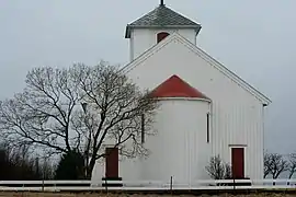 Hildre Church near Brattvåg
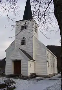 Hamnsund Church near Søvik
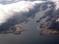 View of Brattvåg village
 View of Lepsøya island
References
- "Navn på steder og personer: Innbyggjarnamn" (in Norwegian). Språkrådet.
- "Forskrift om målvedtak i kommunar og fylkeskommunar" (in Norwegian). Lovdata.no.
- Statistisk sentralbyrå (2018). "Table: 06913: Population 1 January and population changes during the calendar year (M)" (in Norwegian). Retrieved 2019-08-04.
- Statistisk sentralbyrå. "09280: Area of land and fresh water (km²) (M)" (in Norwegian). Retrieved 2019-08-04.
- Jukvam, Dag (1999). "Historisk oversikt over endringer i kommune- og fylkesinndelingen" (PDF) (in Norwegian). Statistisk sentralbyrå.
- "Om nye Ålesund: Bakgrunn" (in Norwegian). Nye Ålesund kommune. Retrieved 2017-10-14.
- Rygh, Oluf (1908). Norske gaardnavne: Romsdals amt (in Norwegian) (13 ed.). Kristiania, Norge: W. C. Fabritius & sønners bogtrikkeri. p. 206.
- "Civic heraldry of Norway - Norske Kommunevåpen". Heraldry of the World. Retrieved 2019-08-03.
- Hansen, Tore, ed. (2016-05-12). "kommunestyre". Store norske leksikon (in Norwegian). Kunnskapsforlaget. Retrieved 2019-04-06.
- "Table: 04813: Members of the local councils, by party/electoral list at the Municipal Council election (M)" (in Norwegian). Statistics Norway.
- "Tall for Norge: Kommunestyrevalg 2011 - Møre og Romsdal" (in Norwegian). Statistics Norway. Retrieved 2019-10-19.
- "Kommunestyrevalget 1995" (PDF) (in Norwegian). Oslo-Kongsvinger: Statistisk sentralbyrå. 1996. Retrieved 2020-04-26.
- "Kommunestyrevalget 1991" (PDF) (in Norwegian). Oslo-Kongsvinger: Statistisk sentralbyrå. 1993. Retrieved 2020-04-26.
- "Kommunestyrevalget 1987" (PDF) (in Norwegian). Oslo-Kongsvinger: Statistisk sentralbyrå. 1988. Retrieved 2020-04-26.
- "Kommunestyrevalget 1983" (PDF) (in Norwegian). Oslo-Kongsvinger: Statistisk sentralbyrå. 1984. Retrieved 2020-04-26.
- "Kommunestyrevalget 1979" (PDF) (in Norwegian). Oslo: Statistisk sentralbyrå. 1979. Retrieved 2020-04-26.
- "Kommunevalgene 1975" (PDF) (in Norwegian). Oslo: Statistisk sentralbyrå. 1977. Retrieved 2020-04-26.
- "Kommunevalgene 1972" (PDF) (in Norwegian). Oslo: Statistisk sentralbyrå. 1973. Retrieved 2020-04-26.
- "Kommunevalgene 1967" (PDF) (in Norwegian). Oslo: Statistisk sentralbyrå. 1967. Retrieved 2020-04-26.
- "Kommunevalgene 1963" (PDF) (in Norwegian). Oslo: Statistisk sentralbyrå. 1964. Retrieved 2020-04-26.
- "Kommunevalgene og Ordførervalgene 1959" (PDF) (in Norwegian). Oslo: Statistisk sentralbyrå. 1960. Retrieved 2020-04-26.
- "Kommunevalgene og Ordførervalgene 1955" (PDF) (in Norwegian). Oslo: Statistisk sentralbyrå. 1957. Retrieved 2020-04-26.
- "Kommunevalgene og Ordførervalgene 1951" (PDF) (in Norwegian). Oslo: Statistisk sentralbyrå. 1952. Retrieved 2020-04-26.
- "Kommunevalgene og Ordførervalgene 1947" (PDF) (in Norwegian). Oslo: Statistisk sentralbyrå. 1948. Retrieved 2020-04-26.
- "Kommunevalgene og Ordførervalgene 1945" (PDF) (in Norwegian). Oslo: Statistisk sentralbyrå. 1947. Retrieved 2020-04-26.
- "Kommunevalgene og Ordførervalgene 1937" (PDF) (in Norwegian). Oslo: Statistisk sentralbyrå. 1938. Retrieved 2020-04-26.
| Wikimedia Commons has media related to Haram. |
External links
- Municipal fact sheet from Statistics Norway (in Norwegian)
 Møre og Romsdal travel guide from Wikivoyage
Møre og Romsdal county, Norway | |||||
|---|---|---|---|---|---|
 |
|  | |||
| Authority control |
|---|