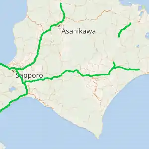
Hidaka Expressway
The Hidaka Expressway (Japanese:
| |
|---|---|
| |
| Route information | |
| Maintained by East Nippon Expressway Company/Ministry of Land, Infrastructure, Transport and Tourism | |
| Length | 59.9 km[1] (37.2 mi) |
| Existed | 1998–present |
| Component highways | |
| Major junctions | |
| West end | |
| East end | Hokkaido Route 208 in Hidaka, Hokkaido |
| Highway system | |
| National highways of Japan Expressways of Japan | |

Naming
The name Hidaka ("sun high") is derived from the province of the same name established in 1869, which in turn was named after an unknown country "in the Eastern wilds" called Hitakami in the Nihonshoki, a history book written in 720. There is no direct connection between the Hitakami of the Nihonshoki and the modern Hidaka Subprefecture.[3]
Route description
Lane configuration
| Section | Total lanes = Westbound lanes + Eastbound Lanes | Speed limit | Toll |
|---|---|---|---|
| Tomakomai-higashi IC – Numanohata-nishi IC | 4=2+2 | 100 km/h | Yes |
| Numanohata-nishi IC – Numanohata-higashi IC | 2=1+1 ※partially, 4=2+2 |
80 km/h | No |
| Numanohata-higashi IC – Atsuma IC | 4=2+2 | 100 km/h | |
| Atsuma IC – Hidaka Atsuga IC | 2=1+1 ※partially, 4=2+2 | 70 km/h |
History
The first section of the Hidaka Expressway to open was a 19.7-kilometer (12.2 mi)-long section between the western terminus at the Dō-Ō Expressway in Tomakomai and Atsuma in 1998.[4] In consideration of the effects of the 2011 Tōhoku earthquake and tsunami, it was decided by MLIT that future sections of the expressway should follow a path further inland to avoid inundation by a tsunami. This decision has delayed further construction of the expressway.[5]
The expressway was temporarily closed after being damaged by the 2018 Hokkaido Eastern Iburi earthquake.[6]
Future
Construction of the expressway is to be continued east to the town of Urakawa on the southeastern point of the island of Hokkaido.[7]
Junction list
The entire expressway is in Hokkaido.
| Location | km[1] | mi | Exit | Name | Destinations | Notes | |
|---|---|---|---|---|---|---|---|
| Tomakomai | 0 | 0.0 | 22/TB | Tomakomai-higashi | Western terminus | ||
| 4.0 | 2.5 | 1 | Numanohata-nishi | Eastbound exit, westbound entrance | |||
| 7.9 | 4.9 | 2 | Numanohata-higashi | Westbound exit, eastbound entrance | |||
| 11.8 | 7.3 | 3 | Tomato-chuo | ||||
| Atsuma | 19.7 | 12.2 | 4 | Atsuma | Hokkaido Route 287 – Central Atsuma, Urakawa | ||
| Mukawa | 28.1 | 17.5 | 5 | Mukawa | Hokkaido Route 10 – Central Mukawa, Atsuma | ||
| Hidaka | 39.9 | 24.8 | 6 | Hidakatomikawa | |||
| 45.7 | 28.4 | 7 | Hidakamonbetsu | Hokkaido Route 351 – Urakawa, Hirotomi | Eastbound exit, westbound entrance | ||
| 59.9 | 37.2 | 8 | Hidaka Atsuga | Hokkaido Route 208 – Central Atsuga, Shinwa | Eastbound exit, westbound entrance. Eastern terminus as of December 2018 | ||
| 1.000 mi = 1.609 km; 1.000 km = 0.621 mi | |||||||
References
- Google (4 December 2018). "Route of Hidaka Expressway" (Map). Google Maps. Google. Retrieved 4 December 2018.
- "Japan's Expressway Numbering System". www.mlit.go.jp.
- . Page:Nihongi by Aston.djvu – via Wikisource.
- "About Hidaka Expressway (General Route 235)". Retrieved 3 December 2018.
- https://web.archive.org/web/20151224110432/http://www.muromin.mnw.jp/murominn-web/back/2015/07/22/20150722m01.jpg
- "北海道管内で地震による通行止めを実施しています" [We are carrying out a road closure due to an earthquake within Hokkaido]. East Nippon Expressway Company. 6 September 2018. Archived from the original on 6 September 2018. Retrieved 3 December 2018.
- https://www.hkd.mlit.go.jp/ky/ki/chousei/ud49g7000000ohkn-att/h251128_3_4_1.pdf
