Seto-Chūō Expressway
The Seto-Chūō Expressway (瀬戸中央自動車道, Seto-Chūō Jidōsha-dō) is a tolled expressway that connects Okayama and Kagawa prefectures in Japan across a series of five small islands in the Seto Inland Sea. Built between 1978 and 1988, it is one of the three routes of the Honshu-Shikoku Bridge Expressway Company connecting Honshū and Shikoku islands. The route is signed E30 under Ministry of Land, Infrastructure, Transport and Tourism's "2016 Proposal for Realization of Expressway Numbering."[1]
| |
|---|---|
| Route information | |
| Maintained by Honshu-Shikoku Bridge Expressway Company | |
| Length | 37.3 km (23.2 mi) |
| Existed | 1988–present |
| Component highways | |
| Major junctions | |
| North end | Hayashima Interchange in Kurashiki, Okayama |
| South end | Sakaide Interchange in Sakaide, Kagawa |
| Highway system | |
| National highways of Japan Expressways of Japan | |
Route description
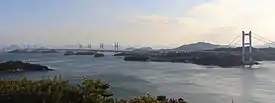
The expressway is 37.3 kilometres (23.2 mi) long with 20.8 kilometres (12.9 mi) of that stretch consisting of bridges, chiefly the Great Seto Bridge. The expressway has four lanes along the entire route from Sakaide, Kagawa to Kurashiki in Okayama. The speed limit is 100 km/h from the expressway's northern terminus at Hayashima Interchange in Kurashiki to Kojima Interchange, also in Kurashiki. The southern remainder of the route has a speed limit set at 80 km/h.[2]
Junction list
TB= Toll booth, SA= Service Area, PA= Parking Area
| Prefecture | Location | km | mi | Exit | Name | Destinations | Notes |
|---|---|---|---|---|---|---|---|
| Through to | |||||||
| Okayama | Kurashiki | 0 | 0.0 | 1/TB | Hayashima | ||
| 6.8 | 4.2 | PA | Tsubue | ||||
| 8.2 | 5.1 | 2 | Mizushima | Okayama Prefecture Route 21 | |||
| 15.0– 15.6 | 9.3– 9.7 | SA | Kōnoike | The northbound SA is at 15.0 km, the southbound SA is at 15.6 km | |||
| 18.8 | 11.7 | 3 | Kojima | Okayama Prefecture Route 21– Mizushima Industrial Area, Okayama | |||
| Kagawa | Sakaide | 22.6 | 14.0 | — | Hitsuishijima | Kagawa Prefecture Route 273– Hitsuishi Island | General vehicles are prohibited from using the exit |
| 24.4 | 15.2 | — | Iwakurojima | Unnamed Road– Iguro Island | General vehicles are prohibited from using the exit | ||
| 26.4 | 16.4 | — | Yoshima | Kagawa Prefecture Route 274– Yoshima Island | General vehicles are prohibited from using the exit | ||
| 26.4 | 16.4 | PA | Yoshima | ||||
| 34.7 | 21.6 | 4 | Sakaide-kita | Kagawa Prefecture Route 192– Central Sakaide | |||
| 37.3 | 23.2 | 5/TB | Sakaide | ||||
| Through to | |||||||
| 1.000 mi = 1.609 km; 1.000 km = 0.621 mi | |||||||
References
- "Japan's Expressway Numbering System". www.mlit.go.jp.
- "E30 SETO CHUO EXPWY". Honshu-Shikoku Bridge Expressway Company. Retrieved 25 February 2019.