High Bridge, Kentucky
High Bridge is an unincorporated community and census-designated place in Jessamine County, Kentucky, United States. As of the 2010 census it had a population of 242.[2] It lies along the lower reaches of the Kentucky River across from the confluence of the Dix River with the Kentucky. The community is part of the Lexington–Fayette Metropolitan Statistical Area.
High Bridge, Kentucky | |
|---|---|
 High Bridge, 2008 | |
 High Bridge  High Bridge | |
| Coordinates: 37°49′12″N 84°43′5″W | |
| Country | United States |
| State | Kentucky |
| County | Jessamine |
| Area | |
| • Total | 2.33 sq mi (6.03 km2) |
| • Land | 2.18 sq mi (5.65 km2) |
| • Water | 0.15 sq mi (0.38 km2) |
| Elevation | 798 ft (243 m) |
| Population (2010) | |
| • Total | 242 |
| • Density | 111/sq mi (42.9/km2) |
| Time zone | UTC-5 (Eastern (EST)) |
| • Summer (DST) | UTC-4 (EDT) |
| Area code(s) | 859 |
| FIPS code | 21-36460 |
| GNIS feature ID | 2629630[1] |
History
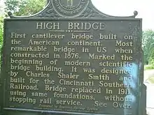
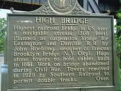
A post office was established in 1879 in the community then known as "North Tower".[3] In 1888, the town was renamed for the landmark High Bridge, a nearly 300-foot-high (91 m) railroad bridge over the Kentucky River. The Kentucky River runs through the Kentucky River Palisades for much of the lower portion of its length. Most of the bridges over it in the area are relatively high ones.
High Bridge was opened in 1876 and was the first cantilever bridge in North America. Standing 275 feet (84 m) over the river between the Palisades, it first carried both passenger and freight trains. The American Society of Civil Engineers has designated it a National Engineering Landmark. The 1876 bridge was replaced in 1911 by a more robust bridge in the same place. This is the current bridge, which stands 308 feet (94 m) above the river. Freight trains of the Norfolk Southern Railway still use this bridge several times a day.
The Palisades were a popular spot for picnics and dances. An open-air roofed ballroom was built there for dances and has been preserved. A small playground and park adjoin the Palisades property.
A brand of bottled water named for the community depicts the bridge on its label. Highbridge Springs water is well-known to the University of Kentucky Wildcats. The Wildcat mascot is used on the bottle label to show support for the team. The bottle name is "Swish".
Bethel Academy, the first Methodist school west of the Appalachians, was established in the High Bridge vicinity in 1790.[4]
Geography
The High Bridge census-designated place consists of the community of High Bridge as well as rural land comprising the inside of the bend on the Kentucky River where the bridge is located. Kentucky Route 29 leads northeast from High Bridge 4.5 miles (7.2 km) to Wilmore, and Nicholasville, the Jessamine county seat, is 10 miles (16 km) northeast of High Bridge.
According to the U.S. Census Bureau, the High Bridge CDP has a total area of 2.3 square miles (6.0 km2), of which 2.2 square miles (5.6 km2) are land and 0.2 square miles (0.4 km2), or 6.36%, are water.[2]
References
- U.S. Geological Survey Geographic Names Information System: High Bridge Census Designated Place
- "Geographic Identifiers: 2010 Census Summary File 1 (G001): High Bridge CDP, Kentucky". American Factfinder. U.S. Census Bureau. Archived from the original on February 13, 2020. Retrieved June 25, 2018.
- Rennick, Robert M. (1987). Kentucky Place Names. University Press of Kentucky. p. 139. Retrieved 2013-04-28.
- Young, Bennett Henderson. A History of Jessamine County, Kentucky, From Its Earliest Settlement to 1898, Courier-Journal Job Printing, 1898, 171.
External links
- Jessamine County Kentucky Tourism - High Bridge
- High Bridge Springs Water
- Digitized images from the Louis Edward Nollau High Bridge Photographic Collection, 1910-1912, housed at the University of Kentucky Libraries Special Collections Research Center
Municipalities and communities of Jessamine County, Kentucky, United States | ||
|---|---|---|
| Cities | 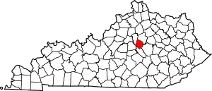 Location of Jessamine County, Kentucky | |
| CDP | ||
| Other unincorporated communities | ||
| Ghost towns | ||
| ||