Kentucky River
The Kentucky River is a tributary of the Ohio River, 260 miles (418 km) long,[2] in the U.S. Commonwealth of Kentucky. The river and its tributaries drain much of the central region of the state, with its upper course passing through the coal-mining regions of the Cumberland Mountains, and its lower course passing through the Bluegrass region in the north central part of the state. Its watershed encompasses about 7,000 square miles (18,000 km2). It supplies drinking water to about one-sixth of the population of the Commonwealth of Kentucky.
| Kentucky River | |
|---|---|
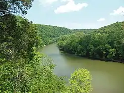 The Kentucky River Palisades at Raven Run Park | |
| Location | |
| Country | United States |
| State | Kentucky |
| Physical characteristics | |
| Source | |
| • location | Beattyville |
| • elevation | 669 ft (204 m) |
| Mouth | |
• location | Ohio River at Carrollton |
| Length | 259 mi (417 km) |
| Basin size | 7,110 sq mi (18,400 km2) |
| Discharge | |
| • location | Lockport |
| • average | 8,924 cu ft/s (252.7 m3/s), USGS water years 1977-2019[1] |
The river is no longer navigable above Lock 4 at Frankfort. Concrete bulkheads have been poured behind the upper lock gates of Locks 5-14 to strengthen the weakest link in the dam structures. All 14 dams are now under the management of the state-run Kentucky River Authority. The primary importance of the locks today is to maintain a pool that allows the city of Lexington to draw its drinking water from the river. Despite the fact that the Lexington area receives well over 40 inches (1,000 mm) of precipitation annually, the limestone, karst geology of that area means that surprisingly little natural surface water is found in the region.
Winchester, Beattyville, Irvine, Richmond, Lancaster, Nicholasville, Harrodsburg, Wilmore, Versailles, Lawrenceburg, and Frankfort also draw water from the river for their municipal water supplies. It is estimated that over 700,000 people depend on the river for water.
Description
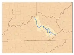
The main stem of the Kentucky River is formed in Eastern Kentucky at Beattyville, in Lee County, by the confluence of the North and South Forks at about 670 feet (200 m) elevation. The Middle Fork enters the North Fork about five miles above Beattyville. The river flows generally northwest, in a highly meandering course through the mountains, through the Daniel Boone National Forest, then past Irvine and Boonesborough, then southwest, passing south of Lexington, then north through Frankfort. It joins the Ohio at Carrollton.
Approximately 15 miles (24 km) southeast of Boonesborough it is joined by the Red River. Approximately 20 miles (32 km) west of Boonesborough it is joined by Silver Creek. At High Bridge, it is joined by the Dix River. At Frankfort, it is joined by Benson Creek; that confluence was the junction of Kentucky's three original counties. At Monterey, pproximately 10 miles (16 km) north of Frankfort, it is joined by Elkhorn Creek, which drains much of the Inner Bluegrass region.
Between Clays Ferry in Madison County and Frankfort, the river passes through the Kentucky River Palisades, a series of dramatic steep gorges approximately 100 miles (160 km) in length.
Forks
North Fork
The North Fork Kentucky River is approximately 168 miles (270 km) long.[2] It rises on the northwest side of Pine Mountain, in the Appalachians of extreme southeastern Kentucky, in eastern Letcher County near the Virginia state line in Payne Gap, near the intersection of US 23 and US 119. It flows generally northwest, in a winding course through the mountainous Cumberland Plateau, past Whitesburg, Hazard and Jackson. It receives Rockhouse Creek at Blackey near its source. Approximately 8 miles (13 km) southeast of Hazard, it receives the Carr Fork. It receives Troublesome Creek at Haddix, southeast of Jackson. Three miles upstream from its confluence with the South Fork, it receives the Middle Fork. It joins the South Fork to form the Kentucky at Beattyville. At Airdale, the river has a mean average discharge of approximately 863 cubic feet per second, per data collected during the period 1930-1942.[3]
Middle Fork
The Middle Fork Kentucky River is a tributary of the North Fork Kentucky River, approximately 105 miles (169 km) long,[2] in southeastern Kentucky. It rises in the Appalachian Mountains in southernmost Leslie County, approximately 16 miles (26 km) from the Virginia state line, and flows north through the Cumberland Plateau past Hyden. At Buckhorn, it is impounded to form the Buckhorn Lake reservoir. North of the reservoir it flows generally northwest and joins the North Fork in Lee County, approximately 5 miles (8 km) east of the confluence of the North and South forks at Beattyville. At Tallega, the river has a mean annual discharge of 792 cubic feet per second.[4]
South Fork
The South Fork Kentucky River is approximately 45 miles (72 km) long.[2] It is formed in Clay County, at the town of Oneida in the Daniel Boone National Forest, approximately 10 miles (16 km) northeast of Manchester, by the confluence of Goose Creek and the Red Bird River. Bullskin Creek enters just downstream. The South Fork flows generally north in a highly meandering course through the mountainous Cumberland Plateau region. It joins the North Fork to form the Kentucky at Beattyville. At Booneville, the river has a mean annual discharge of 1,052 cubic feet per second.[5]
Floods
Kentucky River flooding has been recorded since the early 1800s. Swiss immigrant and lock-keeper, Frank Wurtz, recorded the floods from 1867 on and spoke with local farmers to learn of earlier ones. They told him of great floods in 1817, 1832, 1847, and 1854. Wurtz documented the floods of 1867, 1880, and 1883, which he claims was five feet taller than the high tide of the 1847 flood. The waters of the 1883 flood washed his post away.[6]
On January 1, 1919, the waters rose 10 feet in ten hours at Frankfort, dealing damage to many smaller towns along the river. In November of the same year, the waters rose 3 feet in one hour at Frankfort. In 1920, flooding caused the sewers in Frankfort to back up. There was also major flooding in early 1924 and late December 1926.[6]
Floods hit Kentucky in 1927, causing widespread damage in the Kentucky River basin, in communities such as Neon, Whitesburg, and Hazard. Hundreds were forced from their homes.[7]
Politics of flooding in the 1930s
Throughout the 1930s, the area, already suffering from the economic depression, had to deal with several floods, including a particularly bad one in 1936. As the Ohio river flooded, it backed into the lower Kentucky. The crest reached 42.7 feet (13.0 m) tall, and flooded half of Frankfort, completely isolating the Old State Capitol. In all, 12,000 square miles (31,000 km2) of the Ohio valley were flooded.[8]
The 1937 flooding, exacerbated by cold weather, caused civil unrest. In the Kentucky State Reformatory at Frankfort, the water rose to 6 feet (1.8 m) in the walls. With the downstairs population moving up a floor, racial tensions erupted. 24 prisoners tried to escape, but after a warning shot was fired, only one man left. There was no clean water or food, and so the population of 2,900 was moved to the "feeble-minded institute" on the hill next to the prison. Carpenters were brought in to build small, temporary housing units. Due to the unrest the prison riots brought to Frankfort, the National Guard was brought in to oversee the makeshift prison. The prisoners considered to be too dangerous for the setting were sent to Lawrenceburg and Lexington. The governor at the time, Happy Chandler, successfully pushed for a new reformatory in LaGrange.[9]
While the public was still dealing with the effects of the flooding, Kentucky Utilities opened the Dix Dam spillways, which added more height to the flood waters. When it was turned off, 3 feet (0.91 m) extra of water were added. In Mercer county, the ferry connecting to the shore of Woodford washed away and was never replaced. A flood in 1939 rose slightly higher in Hazard than the flood in 1937.[6]
Residents in the Kentucky River watershed demanded the federal government do more to control floods. Kentucky Hydro-Electric began pushing for a 162 feet (49 m) dam 1 mile (1.6 km) above Booneville on the South Fork as early as 1925. For a variety of reasons, many people protested this, including the fact that the dam would back up South Fork for over 28 miles (45 km). In 1939, President Franklin Roosevelt signed the Flood Control Act of 1938, which authorized construction or study of many reservoirs by the U.S. Army Corps of Engineers, but only two small lakes, Carr Fork and Buckhorn, were built in the Kentucky River watershed. The most controversial project, a Red River dam that would have flooded most of the river's scenic gorge, was abandoned in 1975.
Recreation
The largest goldeye ever taken in the state of Kentucky (2 pounds .64 ounces (0.925 kg)) was caught in the Kentucky River.[10]
See also
Notes
- "USGS Water-Year Summary for Site 03290500". waterdata.usgs.gov. Archived from the original on 2020-08-30. Retrieved 2020-08-30.
- U.S. Geological Survey. National Hydrography Dataset high-resolution flowline data. The National Map Archived 2012-03-29 at the Wayback Machine, accessed June 13, 2011
- https://waterdata.usgs.gov/ky/nwis/annual/?format=sites_selection_links&search_site_no=03280500&agency_cd=USGS&referred_module=sw
- https://waterdata.usgs.gov/ky/nwis/annual/?format=sites_selection_links&search_site_no=03281000&agency_cd=USGS&referred_module=sw
- https://waterdata.usgs.gov/ky/nwis/annual/?format=sites_selection_links&search_site_no=03281500&agency_cd=USGS&referred_module=sw
- Williams, Ellis (2000). The Kentucky River. UKnowledge: University of Kentucky. pp. 107–128. ISBN 9780813158143.
- "9 Jul 1993, Page 3 - The Courier-Journal at Newspapers.com". Courier-Journal. Retrieved 2018-10-23.
- The Kentucky Encyclopedia (2000). "FLOOD OF 1937". www.kyenc.org. Retrieved 2018-10-23.
- The Kentucky Encyclopedia (2000). "PRISONS". www.kyenc.org. Retrieved 2018-10-23.
- "Kentucky State Record Fish List". Kentucky Department of Fish and Wildlife Resources. 2006-04-17. Archived from the original on 2007-02-10. Retrieved 2007-02-17.
References
- Clark, Thomas D. "The Kentucky". The Rivers of America Series, 1942. reprinted 1969 by Henry Clay Press
- Collins, Robert F. "A History of the Daniel Boone National Forest". (1975)
- Arthur Benke & Colbert Cushing, Rivers of North America. Elsevier Academic Press, 2005 ISBN 0-12-088253-1
- Rhodes, Captain Rick, The Ohio River --In American History and Voyaging on Today's River has a section on the Kentucky River; Heron Island Guides, 2007, ISBN 978-0-9665866-3-3
External links
| Wikisource has the text of an 1879 American Cyclopædia article about Kentucky River. |
| Wikimedia Commons has media related to Kentucky River. |
- Kentucky River Authority
- NWS: Kentucky River Watershed Watch
- Kentucky River Museum in Boonesbourough
- Kentucky River Water Quality
- Kentucky River Palisades
- Flood Inundation Maps for a 6.5-mile Reach of the Kentucky River at Frankfort, Kentucky United States Geological Survey
- U.S. Geological Survey Geographic Names Information System: Kentucky River
- . Collier's New Encyclopedia. 1921.
- . New International Encyclopedia. 1905.