High Street (Columbus, Ohio)
High Street is a major thoroughfare in Central Ohio, predominantly in Franklin County and Columbus. It stretches from the northern border of Columbus in Delaware County south to the southern boundary of Franklin County just past Columbus's municipal boundaries. The street is considered one of Columbus's two main roads, along with Broad Street.
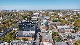
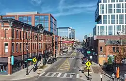 High Street in the Short North looking north | |
| Location | Delaware and Franklin counties, Ohio |
|---|---|
| North end | Columbus (northern boundary) |
| South end | Hamilton Township |
| East | 3rd Street |
| West | Wall or Front Street |
Route description
High Street extends north and south far into Ohio, though it is named High Street starting at the northern end of Columbus (in Delaware County). North of this it is U.S. Route 23. Continuing south, the road quickly enters Franklin County and passes through some northerly suburbs in Columbus. The road enters Worthington and Riverlea, two municipalities that are enclaves of Columbus. The street is the primary corridor of Worthington's central business district. High Street resumes in Columbus, going through its Clintonville neighborhood. There it adjusts from running approximately due south to slightly southeast. It continues through Old North Columbus and then the University District, where it also passes by the Ohio State University. Immediately afterward, it enters the Short North Arts District, a historic and shopping district centered around High Street. The road continues into Downtown Columbus. There the street enters Capitol Square, intersecting with Broad Street, the other main artery of the city. The square is the cultural center of downtown, and includes the Ohio Statehouse, the state capitol building. High Street continues south out of Downtown through the Brewery District by German Village, and readjusts more south upon entering Merion Village. It continues through a large stretch of the city's South Side, where it terminates just south of the city borders in Hamilton Township, continuing on as U.S. Route 23.[1]
History
High Street has been one of Columbus's two main corridors since its founding, along with Broad Street, meeting at a 100 percent corner downtown.[2] The street (among other main corridors) was laid out from the city's founding in 1812 into the following year.[3]
Attributes
Broad Street and High Street both traverse beyond the extent of the city; High Street is the longest in Columbus, running 13.5 mi (21.7 km) (23.4 across the county), while Broad Street is longer across the county, at 25.1 mi (40.4 km).[2] The city's street plan follows a grid pattern with the intersection of Broad and High Streets at its center.[4] The address system begins its numbering at the intersection of Broad and High, with numbers increasing in magnitude with distance from Broad or High, as well as cardinal directions used alongside street names.[5]
For public transportation, numerous Central Ohio Transit Authority (COTA) routes utilize High Street. The CBUS, route 102, and the Night Owl run on a long extent of the street; the CBUS the city's free downtown circulator, while the Night Owl provides late-night service.
Beside the historic landmarks listed below, the street has numerous cultural landmarks and attractions. These include Highbanks Metro Park, the Pontifical College Josephinum, the Orange Johnson House Museum, the Newport Music Hall, the Ohio State University, the university's Billy Ireland Cartoon Library & Museum, the Greater Columbus Convention Center, the Lazarus Building, and the Franklin County Government Center.
Historical landmarks
Buildings on High Street can have one of several types of official landmark designations:
- The Columbus Register of Historic Properties (CRHP) is the city-wide historic register. The city's Historic Resources Commission and Historic Preservation Office are responsible for identifying and designating its landmarks and the buildings in the city's historic districts.
- The National Register of Historic Places (NRHP) is the United States federal government's official list of districts, sites, buildings, structures and objects deemed worthy of preservation for their historical significance.[6]
- The National Historic Landmark (NHL) program focuses on places of significance in American history, architecture, engineering, or culture; all NHL sites are also on the NRHP.[7]
Individual landmarks
Below is a list of historic sites on High Street, from north to south. Historic districts are not included in this table, but are mentioned in § Historic districts. Buildings within historic districts, but no individual landmark designation, are not included in this table.
| Name | Image | Address | Neighborhood | CRHP | NRHP | Notes |
|---|---|---|---|---|---|---|
| Northmoor Engine House / Station #19 |  | 3601 N. High Street | Northmoor (Clintonville) | Yes | ||
| White Castle Restaurant | 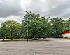 | 2725 N. High Street | University District | Yes | Built in 1929; moved to Orient, Ohio in 1986; later to Rolla, Missouri. Site pictured. | |
| 1379 N. High Street Apartment Building | 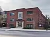 | 1379 N. High Street | University District | Yes | ||
| York Lodge No. 563 | 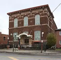 | 1276 N. High Street | University District | Yes | ||
| Union Station arcade | 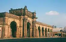 | 370-400 N. High Street | Downtown | Yes | Demolished in 1976, delisted in 1999 | |
| Columbia Larrimer Building | 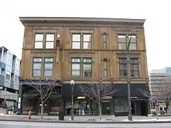 | 161-167 N. High Street | Downtown | Yes | Yes | |
| Atlas Building | _-_6032788761.jpg.webp) | 8 E. Long Street | Downtown | Yes | ||
| Citizens Savings & Trust Company | _-_11572317353.jpg.webp) | 51 N. High Street | Downtown | Yes | Also part of a national historic district | |
| Ohio Statehouse |  | 1 Capitol Square | Downtown | Yes | Yes | Also a National Historic Landmark |
| Ohio National Bank | 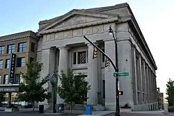 | 167 S. High Street | Downtown | Yes | ||
| Great Southern Hotel and Theatre | 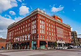 | 310 S. High Street | Downtown | Yes | Yes | Also part of a city and national historic district |
| Schlee-Kemmler Building |  | 326 S. High Street | Downtown | Yes | Yes | Also part of a city and national historic district |
| Krumm Residence | 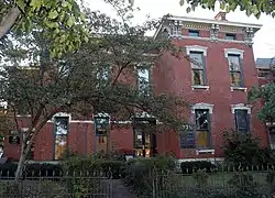 | 975-979 S. High Street | Brewery District | Yes | Yes | |
| Dan's Drive-In | 1881 S. High Street | Merion Village | Yes |
Historic districts
There are numerous historic districts through which High Street passes. Buildings in these districts with individual landmark designations are described in § Individual landmarks. From north to south, the districts are:
- Worthington Historic District, a national historic district
- Old Beechwold, a city and national historic district
- North Columbus Commercial Historic District, a national historic district
- Northwood Park, a city historic district
- Near Northside Historic District, a national historic district (overlaps with Victorian Village)
- Victorian Village, a city historic district
- Fifth Avenue and North High Historic District, a national historic district (mostly within Victorian Village)
- Italian Village, a city historic district
- Old North End Historic District, a national historic district
- Third Avenue and North High Historic District, a national historic district (mostly within Italian Village)
- Short North Historic District, a national historic district
- North Market Historic District, a city and national historic district
- High and Gay Streets Historic District, a national historic district
- South High Commercial Historic District, a city and national historic district
- Brewery District, a city historic district (German Village is one block over)
- Schlee Brewery Historic District, a national historic district
See also
References
- Google (July 7, 2020). "Overview map of Broad Street" (Map). Google Maps. Google. Retrieved July 7, 2020.
- Elliott, Susannah (July 28, 2015). "What is the longest, continuously running street in Columbus?". The Columbus Dispatch. Retrieved May 21, 2020.
- "Broad Street Bungled Yet Again". Columbus Navigator. April 9, 2019.
- Moore, Opha (1930). History of Franklin County Ohio. Topeka-Indianapolis: Historical Publishing Company. p. 127.
- Federal Writers' Project employees (1946). The Ohio Guide (3rd ed.). Oxford University Press. p. 246. ISBN 9781603540346. Retrieved April 27, 2020.
- "How to List a Property". National Register of Historic Places (U.S. National Park Service). November 26, 2019. Retrieved December 22, 2019.
- "Eligibility". National Historic Landmarks (U.S. National Park Service). August 29, 2018. Retrieved December 22, 2019.
External links
 Media related to High Street (Columbus, Ohio) at Wikimedia Commons