Interstate 270 (Ohio)
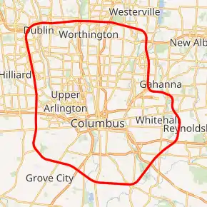
Interstate 270 (I-270) is the beltway loop freeway in the Columbus metropolitan area in the U.S. state of Ohio, commonly known locally as The Outerbelt, or the Jack Nicklaus Freeway. The zero-milepost is at the junction with I-71 east of Grove City, Ohio. I-270, along with I-670, provides access to John Glenn Columbus International Airport. The entire length of I-270 is 54.97 miles (88.47 km). It is one of four Interstate loops not to run concurrently with another Interstate freeway, the others being I-295 in Florida, I-485 in North Carolina, and I-610 in Texas.
| ||||
|---|---|---|---|---|
| The Outerbelt Jack Nicklaus Freeway | ||||
I-270 highlighted in red | ||||
| Route information | ||||
| Auxiliary route of I-70 | ||||
| Maintained by ODOT | ||||
| Length | 54.97 mi[1] (88.47 km) | |||
| Existed | 1962–present | |||
| History | completed in 1975 | |||
| Major junctions | ||||
| Beltway around Columbus, Ohio | ||||
| ||||
| Location | ||||
| Counties | Franklin | |||
| Highway system | ||||
| ||||

Route description
Interstate 270 provides access to several suburbs and towns surrounding Columbus, including Grove City, Westerville, Worthington, Hilliard and Dublin. Although it started as a rural bypass of Columbus, many parts of it, primarily the Northern section, have become more traveled and more congested over the years, making it less popular as a bypass and more widely regarded as a “suburb connector.”
I-270 starts at I-71 on the southern side, marked as exit 1, and forms a cloverstack interchange. It then makes its way clockwise around the city with three lanes, intersecting U.S. Route 62 (US 62), Georgesville Road, and US 40 before its next major interchange, a cloverstack with I-70. Here, it becomes a four-lane freeway as it passes through Hilliard and Dublin.
The Northwestern “corner” of I-270 has a cloverstack interchange with US 33/SR 161. It then makes a sharp right as it heads towards Worthington. In Worthington are the notoriously congested interchanges of three major roadways, State Route 315 (SR 315), US 23, and I-71. This is the location of the recent North Side Mega-Fix, which fixed the heavy weaving section between US 23 and SR 315, however the project also worsened weaving between US 23 and I-71, leading to frequent mile-long backups.
After passing through Worthington, I-270 passes through Westerville, intersecting Cleveland Avenue and SR 3. After going through Westerville, the freeway intersects SR 161 at a cloverstack interchange, and the freeway is divided into local-express lanes, with three local and three express lanes in each direction. This is where the freeway goes through Easton, a popular shopping destination.
Once the freeway has gone through Easton, the local-express lanes merge right before the interchange of I-670, creating a weaving section. This weave is currently being fixed in the Northbound direction as part of the I-670 Smartlane Project. After intersecting I-670, the freeway makes a hard turn left and then right to avoid both the airport and Gahanna. In between these two turns is a parclo interchange with Hamilton Road, and after the turns is a cloverstack with SR 16. The freeway then divides from four lanes into two express lanes and three local lanes. This configuration continues up until the interchange with I-70, another cloverstack. This interchange is planned to be entirely reconstructed to construct two flyover ramps, as well as unweave and widen I-70, as part of the Far East Freeway Study.
After the I-70 interchange, the freeway becomes much more of a rural route, with only three lanes in each direction. The next interchange after I-70 is with US 33, a cloverleaf. After this, the freeway intersects Alum Creek Drive at a parclo, and US 23 at a cloverstack before the freeway meets back with I-71, forming a loop.
History

Planning
Planning for an outerbelt around Columbus began in the late 1950s. By the early 1960s detailed planning for the route had begun, and several controversies arose. The first involved the location of the northern segment, which was originally planned to pass south of Worthington, passing through the Ohio School for the Deaf and just north of the then ten-year-old Graceland Shopping Center. Through vigorous lobbying throughout 1961, and with the help of Ohio Governor Michael DiSalle, residents were able to get the outerbelt relocated to pass north of Worthington.[2]
Another contentious issue involved the routing of the eastern portion of the outerbelt between Port Columbus International Airport and the city of Gahanna. While the airport wanted the outerbelt pushed out towards Gahanna so as to leave land for future runway expansion, the residents of Gahanna wanted it pushed back towards Columbus. The final compromise led to an interesting kink in I-270 as it jogs around the airport.[3]
Construction
Construction of the outerbelt began in 1962, and work was begun on various disconnected sections. The first portion to be completed connected US Route 23 (US 23) with I-71 south of Columbus.[4] The portion between US 23 and I-71 on the north side opened in August 1967.[5]
The section between I-70 on the West Side and I-71 on the south side opened in August 1970.[6] In late 1970, sections opened on the east side between US 33 and I-70, and between State Route 3 (SR 3) in Westerville and SR 161 on the east side. It was now possible to bypass Columbus using I-270 by going around the south side of the city.[7]
In June 1971, the section between Morse Road and SR 161 on the east side opened. In October 1971, another section on the east side between I-70 and East Main Street opened. It would take four more years to complete the northeast portion of the outerbelt.[8]
The last section of I-270, on the east side, between Hamilton Road and East Broad Street, was opened on August 20, 1975.[9] The total cost of the 10-year construction project was $175 million, compared to the original 1961 estimate of $104 million.
Accidents and incidents
In December 1965, during the construction of the northern section of I-270 across the N&W and NYC railroad tracks between US 23 and I-71, the New York Central's Ohio State Limited was wrecked after it hit a piece of earthmoving machinery, resulting in the operator's death and the injury of several passengers and crew. The train was dumped into the cornfield resulting in a major operation to clean it up.[10]
On November 4, 1968, David R. Booth, age 29, became the first person to die on I-270 when he hit another car while merging onto US 23 from I-270.[11]
In February 1974, three trucks traveling on I-270 on the south side near US 33 were struck by gunfire during a violent Teamsters Strike.[12]
The highway was the subject of national media attention in 2003 when 24 sniper shootings were reported along the southern portion of the Interstate and other neighboring highways in the Ohio highway sniper attacks. Sixty-two-year-old Gail Knisley was shot to death on November 25, 2003, making her the only fatality associated with the string of shootings. Charles A. McCoy, Jr., who had been diagnosed with paranoid schizophrenia in 1996, was accused of the shootings and stood trial in 2005. The first trial with death penalty charges resulted in a hung jury on May 9, 2005, most likely due to McCoy's severe mental illness. Rather than face a retrial, McCoy accepted a plea arrangement where he avoided the death sentence. He was sentenced to 28 years in prison on August 9, 2005.
On January 23, 2017, a gas tanker carrying 8,000 gallons of gasoline tipped over while exiting from SR-161 / US 33 onto I-270 W in Dublin. A massive fire resulted from the crash, as well as multiple small grass fires caused by the gasoline dripping down the sides of the flyover ramp. Both highways were shut down in both directions for the day, and the ramp was shut down for one week as repairs were made. The only fatality was that of the truck driver.[13]
Expansion and noise barriers
In 1978, the first noise barriers were constructed on the portion of I-270 passing near Gahanna. Noise barriers have been slowly added around the length of the 55-mile (89 km) long belt as development has crowded up to the noisy road.[14]
Massive development followed the construction of I-270, especially around the north and northwest sides. The northern suburbs of Westerville, Worthington and Dublin, and Hilliard to the west benefited the most. As in other sizeable cities across America, the effect of this outerbelt driven development was to hasten the decline of the Columbus core. The south portion of I-270 was much slower to develop due to the location of sewage treatment and landfill facilities, as well as quarries and the flood prone Scioto River. Grove City began to develop in the 1990s with the addition of office/warehouse space, and the conversion of Rickenbacker Air Force Base to a civilian air freight facility.
Exit list
The entire route is in Franklin County.
| Location | mi[1][15] | km | Old exit | New exit | Destinations | Notes | |
|---|---|---|---|---|---|---|---|
| Jackson Township | 0.00– 54.97 | 0.00– 88.47 | - | 55 | Signed as exits 55A (north) & 55B (south); I-71 exit 101 southbound, 101A-B northbound | ||
| 2.13 | 3.43 | 2 | 2 | ||||
| Columbus | 4.97 | 8.00 | 3 | 5 | Georgesville Road | Cardinal direction change: westbound becomes northbound & southbound becomes eastbound[lower-alpha 1] | |
| Franklin–Prairie township line | 6.91– 7.04 | 11.12– 11.33 | 4 | 7 | Signed as exits 7A (west) and 7B (east) southbound, northbound combined as exit 7 | ||
| Columbus | 8.69– 8.71 | 13.99– 14.02 | - | 8 | I-70 exit 93 westbound, 93A-B eastbound. | ||
| 10.50 | 16.90 | 6 | 10 | Roberts Road | diverging diamond interchange [16] | ||
| Hilliard | 12.63– 12.64 | 20.33– 20.34 | 7 | 13 | Fishinger Road – Upper Arlington Cemetery Road – Hilliard, Franklin County Fairgrounds | Signed as exits 13A (Fishinger Road) and 13B (Cemetery Road) northbound, southbound combined as exit 13 | |
| 13.8 | 22.2 | 14 | Davidson Road | Proposed | |||
| Columbus | 15.63 | 25.15 | - | 15 | Tuttle Crossing Blvd | ||
| Dublin | 17.29– 17.31 | 27.83– 27.86 | 8 | 17 | Signed as exits 17A (east, north) and 17B (west, south); Cardinal direction change: northbound becomes eastbound & westbound becomes southbound[lower-alpha 2] | ||
| Dublin–Columbus line | 19.82 | 31.90 | 9 | 20 | Sawmill Road – Columbus Zoo and Aquarium, Zoombezi Bay, Muirfield (WB) | First SPUI in Ohio | |
| Sharon Township | 22.78 | 36.66 | 10 | 22 | Signed as exits 22A (south) and 22B (north) (Eastbound) | ||
| 23.78 | 38.27 | 11 | 23 | Formerly Signed as exits 23A (south) and 23B (north) | |||
| Columbus | 25.83 | 41.57 | - | 26 | I-71 exit 119 northbound, 119A-B southbound. | ||
| Columbus–Blendon Township line | 27.38 | 44.06 | 13 | 27 | Signed as exits 27A (south) and 27B (north/west); Eastern terminus of SR 710 last exit to be Interstate 270 Eastbound, at Westerville Road it changes directions to Interstate 270 Southbound | ||
| Blendon Township | 28.71 | 46.20 | 14 | 29 | Cardinal direction change: eastbound becomes southbound & northbound becomes westbound[lower-alpha 3]; SR 3 known as State Street north of I-270 and Westerville Road south of I-270 | ||
| Blendon Township–Columbus line | 30.53 | 49.13 | 15 | 30 | Signed as exits 30A (south) and 30B (north); shares C-D roads with exit 33 | ||
| Columbus | 32.27 | 51.93 | 16 | 32 | Morse Road | No connection to exits 30 or 33 | |
| 32.92 | 52.98 | - | 33 | Easton Way – Easton | Shares C-D roads with exit 30 | ||
| Mifflin Township | 35.16– 35.51 | 56.58– 57.15 | - | 35 | Johnstown Road | Signed as exits 35A (I-670/US 62 west), 35B (US 62 east) and 35C (Johnstown Road) southbound; Only access to Johnstown Road is northbound exit | |
| Gahanna | 37.36 | 60.13 | - | 37 | |||
| Columbus | 39.53 | 63.62 | - | 39 | Signed as exits 39A (west) and 39B (east); Only access to Taylor Station Road is northbound exit (via Old Morrison Road and Westbourne Avenue) | ||
| 41.32 | 66.50 | 20 | 41 | Signed as exits 41A (west) and 41B (east); shares C-D roads with exit 43 | |||
| 42.82 | 68.91 | - | 43 | Signed as exits 43A (west) & 43B (east); shares C-D roads with exit 41; I-70 exit 108 eastbound, 108A-B westbound. | |||
| 46.13 | 74.24 | 22 | 46 | Signed as exits 46A (west) and 46B (east) | |||
| Obetz | 48.98 | 78.83 | 23 | 49 | Cardinal direction change: Southbound becomes westbound & eastbound becomes northbound[lower-alpha 4] | ||
| Hamilton Township | 52.72 | 84.84 | 24 | 52 | Signed as exits 52A (north) and 52B (south) westbound; Access to Scioto Downs (SB) | ||
1.000 mi = 1.609 km; 1.000 km = 0.621 mi
| |||||||
Notes
- As indicated by guide signs and reassurance markers at Georgesville Rd. However, change is noted on the mainline at milepost 4.4.[15]
- As indicated by mile markers.[15]
- As indicated by mile markers and guide signs[15]
- As indicated by guide signs and reassurance markers at Alum Creek Dr. However, change is noted on the mainline after milepost 48.[15]
References
- District 6 staff (January 2006). "ODOT Straight Line Diagram, Franklin IR 270" (PDF). Ohio Department of Transportation. pp. 1–11. Retrieved 2011-08-24.
- "Meeting Decries 'Near' Outerbelt". Columbus Dispatch. February 9, 1961. p. 1A.
- "Ohio Dept of Highways Completes Work on a Proposed New Alignment through Gahanna for the Outerbelt Expressway which Would Permit Future Expansion for Port Columbus". Columbus Dispatch. March 30, 1967. p. 1B.
- "Ohio Highway Department Reports on the Status of 6 Columbus Expressway Projects: Outerbelt, Ft Hayes Interchange, East Freeway, Parsons and Fulton Expressways". Columbus Dispatch. June 16, 1963. p. 14A.
- "The Outerbelt Expressway (I-270) Between the North Freeway and N High St Is Opened at Ceremonies Led by the Worthington Chamber of Commerce". Columbus Dispatch. August 15, 1967. p. 1B.
- "8.5 Mile Stretch of Outerbelt, I-270, Between I-70 West and South Freeway, Will Open 8/17". Columbus Dispatch. August 13, 1970. p. 1B.
- "A Missing Link in the Cols Outerbelt Opens to Traffic Nov 20, Allowing East–West Traffic to Pass Cols; the 3.2 Mile Link Between Rt 33 and I-70 Beats a Thanksgiving Deadline". Columbus Dispatch. November 19, 1970. p. 1A.
- "The Opening of E Main St (Rt 40) over the Outerbelt Is Scheduled for 6/21, and Work on E Main St–NOE–Bixby Rd Intersection May Also Be Completed by that Date". Columbus Dispatch. June 13, 1971. p. 19A.
- "Outerbelt Finish Set for Aug. 20". Columbus Dispatch. July 9, 1975. p. 1C.
- "Dana B. Bolin, 49, of Athens, Ohio, Is Killed and about 30 People Are Injured in the Crash of New York Central's Ohio State Limited Passenger Train in Worthington". Columbus Dispatch. December 19, 1965. p. 1A.
- "David R. Booth, 29, 1066 Corwin Ave, Dies when his Car Collides with Another just North of I-270 Exit onto Rt 23, South of Columbus". Columbus Dispatch. November 4, 1968. p. 1B.
- "Three Trucks Traveling in Convoy on the Columbus Outerbelt near US 33 Are Struck by Gunfire as Violence Continues in the Strike by Independent Truckers". Columbus Dispatch. February 4, 1974. p. 1A.
- "Fiery gasoline-tanker crash kills driver, shuts Route 33, I-270". Columbus Dispatch. January 23, 2017.
- "Noise from the Outerbelt Are Erected in Gahanna; City Threatened To Sue Ohio Dept of Transportation if Barriers Were Not Erected". Columbus Dispatch. June 1, 1978. p. 10B.
- Google (September 20, 2020). "Interstate 270 (Ohio)" (Map). Google Maps. Google. Retrieved September 20, 2020.
- "I-270/Roberts Road Interchange Improvement Project". Ohio Department of Transportation. Retrieved 2 August 2013.