Highway H33 (Ukraine)
H33 is a Ukrainian national highway (H-highway). Passes through the territory of the Odessa region. The route was designated as territorial road T-16-04 until 2013, as a regional road P-70 until 2017, when it was redesignated as a national highway H33.
| |
|---|---|
| Автошлях H33 | |
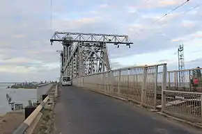 H33. Combined rail-road bridge across the estuary of the Dniester river-estuaries in the Black sea in Zatoka | |
| Route information | |
| Length | 97.2 km[1] (60.4 mi) Ukrainian: Автошлях H33 |
| Existed | 2017–present |
| Major junctions | |
| East end | Odessa |
| West end | Monashi |
| Location | |
| Regions | Odessa Oblast |
| Highway system | |
| Roads in Ukraine
| |

Whole length
The total length of the road, Odessa – Bilhorod-Dnistrovskyi – Monashi - ![]() M15 (together with the entrance to the Port of Chornomorsk), is 97.2 kilometres (60.4 mi). [1][2]
M15 (together with the entrance to the Port of Chornomorsk), is 97.2 kilometres (60.4 mi). [1][2]
Main route
| Route H33 | ||
| Odessa Oblast | ||
| Odessa | 0 kilometres (0 mi) | |
| Ovidiopol Raion | ||
| Prylymanske | ||
| Nova Dolyna | ||
| Velykodolynske | ||
| intersection with | T-1620 | |
| Baraboi | ||
| Ovidiopol | T-1625, T-1641 | |
| Roksolany | ||
| Karolino-Buhaz | T-1647 | |
| Bilhorod-Dnistrovskyi Raion | ||
| Dniester Estuary | ||
| Zatoka | ||
| Budaki Lagoon | ||
| Pryberezhne | ||
| Shabo | T-1610 | |
| Salhany | ||
| Bilhorod-Dnistrovskyi | P72 | |
| Brytivka | ||
| Roskishne | ||
| Monashi intersection with | 96.9 kilometres (60.2 mi) | |
Notes
References
- "Про затвердження переліку автомобільних доріг загального користування державного значення. Постанова № 712". Верховна Рада України (in Ukrainian). Кабінет Міністрів України. 2015-09-16.
- "P-70" (in Russian). Автострада. 2016. Retrieved 2016-03-28.
- "Региональные автодороги Украины. Список, маршрут, расстояние" (in Russian). Автодороги Украины. 2015. Retrieved 2016-03-03.
- "Стан проїзду" (in Ukrainian). Державне агентство автомобільних доріг України. 2016. Archived from the original on 2016-03-10. Retrieved 2016-03-03.
| E-roads in Ukraine | ||
|---|---|---|
| International | ||
| National | ||
| Regional |
| |
| ||
This article is issued from Wikipedia. The text is licensed under Creative Commons - Attribution - Sharealike. Additional terms may apply for the media files.
