Highway H12 (Ukraine)
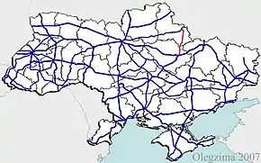
H12 is an important Ukraine national highway (H-highway) in Sumy and Poltava Oblasts, Ukraine, running mainly north–south, and connecting Sumy with Poltava in a more or less straight line. [1][2] It begins in Sumy at Bandera Street (Highway H07/Highway P61) and Illinska Street, and travels straight through central Sumy. It passes through Syrovatka, Boromlya, Trostyanets, Klymentove, Okhtyrka, Khukhra, Kotelva, Velyki Budyshcha, and Dykanka, and then loops around Poltava and terminates at the intersection of Highway M03 and Polovky Street.[3]
_02.jpg.webp)
Entering Dykanka sign in Poltava Oblast
| ||||
|---|---|---|---|---|
| Автошлях H12 | ||||
 | ||||
| Route information | ||||
| Length | 154.4 km (95.9 mi) 170.2 km (105.8 mi) with bypass in Sumy | |||
| Major junctions | ||||
| North end | T1901 T1909 P45 P61 | |||
| South end | ||||
| Location | ||||
| Regions | Sumy Oblast, Poltava Oblast | |||
| Highway system | ||||
Roads in Ukraine
| ||||
Main route
Main route and intersections with other highways in Ukraine.[4]
| Marker | Settlements with intersecting highways | Notes | Highway Interchanges |
|---|---|---|---|
| 0 km | Sumy | T1901 T1909 P45 P61 | |
| Syrovatka (Verkhnya) | P45 | ||
| Trostyanets | T1913 | ||
| Okhtyrka | T1705 T1929 P46 | ||
| Kotelva | T1729 | ||
| Dykanka | T1718 | ||
| 170.2 km | Poltava |
See also
References
| E-roads in Ukraine | ||
|---|---|---|
| International | ||
| National | ||
| Regional |
| |
| ||
This article is issued from Wikipedia. The text is licensed under Creative Commons - Attribution - Sharealike. Additional terms may apply for the media files.