Highways in Croatia
Highways in Croatia are the main transport network in Croatia. The Croatian classification includes several classes of highways:[1]
- The main motorways are named A (autocesta) accompanied by one or two digits. By and large they are controlled-access toll highways with a ticket system.
- Expressways (brza cesta) are limited-access roads with grade-separated intersections and by and large an increased speed limit without tolling. They are similar to motorways, but aren't always dual carriageway, they have no emergency lanes, and their speed limit is always lower. They either have standalone designations or are parts of major state routes (D), see below.
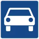
- Roads dedicated for motor vehicles (cesta namijenjena isključivo za promet motornih vozila), which is a category for highways which are limited-access roads, usually similar to multiple-lane motorways/expressways, but which may have slow intersections. It has no specific naming convention, only a dedicated traffic sign, and it mainly includes major state routes (D) or portions thereof, see below. An example is the Jadranska Avenue in Zagreb, designated as Ž1040 county road.[2]
_hr.svg.png.webp)
Other than these, the national road classification includes the following categories which may also be referred to as highways in a general sense, with decreasing order of priority (and applicability of the term highway):[2]
- State roads, which are marked by letter D (državna cesta) and a single, double or triple digit number.
- County roads always are marked by letter Ž (županijska cesta) and a four digit number.
- The lowest classification comprises local roads, marked by letter L (lokalna cesta) and a five digit number.
Road operators differ according to the classification system: The designated motorways are operated by four different concessionaires. The state roads are maintained almost exclusively by Hrvatske ceste, while the county and local roads are managed by various county authorities. The road maintenance agencies are governed by various laws issued by the Parliament as well as bylaws issued by the Ministry of Transport.[1][3]
Motorways
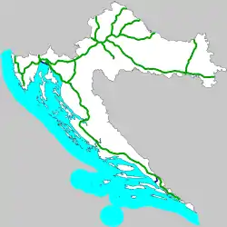
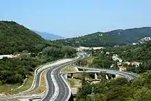
The primary high-speed motorways are called autoceste (Croatian pronunciation: [ˈaʊtotsesta]; singular: autocesta), and they are defined as roads with at least three lanes in each direction (including hard shoulder) and a speed limit of not less than 80 kilometres per hour (50 mph). They are marked with a special road sign, similar to the road sign depicting a motorway/autoroute/autobahn in other parts of Europe.[4] The Croatian motorway (autocesta) network is 1,313.8 kilometres (816.4 mi) long.[5] in 2015-2018 and 1,306.5 km in 2019/2020.[6]
Motorways in Croatia are defined by the Ministry of Sea, Transport and Infrastructure.[3][7][8] The same applies to names of the motorway interchanges and rest areas.[9]
History
A major reason for the motorway construction "mania" of the 2000s (decade) is a previous political halt of the major Croatian highway project, today's A1, in the 1970s and 1980s under former Yugoslavia. When Croatia declared independence in 1991, the only true motorways in the country were Zagreb–Karlovac (the northernmost part of today's A1) and Zagreb-Slavonski Brod (the central part of today's A3), the latter being part of the highway "Bratstvo i jedinstvo". The dream to connect the two largest Croatian cities Zagreb and Split with a motorway (autocesta) went back to the times of the Croatian Spring. However, the construction of this project had not happened during Yugoslav period.
In 2005, the Zagreb-Split route was constructed. In addition, the A1 was extended towards Dubrovnik (currently at Ploče), and the A3 was extended so it connects Zagreb to Croatian borders with both Serbia (near Lipovac) and Slovenia (near Bregana). There is also a motorway from Zagreb to Rijeka, the A6, as well as the A4 motorway from Zagreb to the northeast (Hungarian border) as well as the A2 motorway from Zagreb to the northwest (Slovenian border). The A9 between Pula and the Slovenian border is also largely completed.
The construction of additional motorways has noticeably slowed in the 2010s, but it continues. As of 2014, the A8–Kanfanar-Rijeka, the remaining part of the Istrian Y–is being upgraded from semi-highway status. The other motorways are in various early stages of development, coming up to a total of 11 motorway routes. The A1 is considered unfinished as it is planned to be extended from Ploče to Dubrovnik, but the status is unclear because of the Neum enclave of Bosnia and Herzegovina.
Operators
The network is managed by 3 operators, of which two are funded by government and one by joint venture.[6]
| Operator | Ownership | Motorway[10] | Length (in service) (2019)[10] |
Notes[10] |
|---|---|---|---|---|
| BINA Istra | private company | A8 A9 | 141 km (88 mi) | |
| Autocesta Zagreb – Macelj | state owned company | A2 | 60 km (37 mi) | |
| Hrvatske autoceste | state owned company | A1 A3 A4 A5 A6 A7 A10 A11 | 1,093.5 km (679.5 mi) | A6 was operated by Autocesta Rijeka – Zagreb until 31 December 2020. |
List of motorways
| Motorway | Route[10] | Length (in service) (2019)[10] |
Description | Notes[10] |
|---|---|---|---|---|
| Zagreb - Bosiljevo - Split - Dubrovnik | 481 km (299 mi) | The A1 starts in Lučko interchange, a part of Zagreb bypass where the A3 motorway junction is found. The motorway proceeds south from Zagreb to Karlovac and further on to Bosiljevo 2 interchange where the A6 motorway branches off towards Rijeka. The route continues south to Gospić, Zadar, Šibenik, Split. The southernmost sector of the motorway proceeds from Split to Ploče and Metković.[maps 1] | Section between Ploče and Dubrovnik is planned | |
| Zagreb - Macelj | 60 km (37 mi) | The A2 starts on the border of Slovenia near Macelj. The motorway passes west of Krapina and proceeds south towards Zagreb. The southernmost section of the motorway forms a part of Zagreb bypass and it terminates in Jankomir interchange with the A3 motorway.[maps 2] | ||
| Bregana - Zagreb - Lipovac | 306 km (190 mi) | The A3 starts on the border of Slovenia near Bregana. The motorway passes north of Samobor and proceeds west towards Zagreb, passing to the south of the city and forming a part of Zagreb bypass, where the route contains junctions with the A2, A1 and A4 motorways. It continues east to Kutina, Slavonski Brod, Sredanci interchange with the A5 motorway and further east to Županja and terminating on the border of Serbia near Lipovac[maps 3] | ||
| Zagreb - Goričan | 97 km (60 mi) | The A4 starts on the border of Hungary near Goričan. The motorway passes near Čakovec and Varaždin south towards Zagreb and the southernmost part of the route is a part of Zagreb bypass, where the motorway terminates in Ivanja Reka interchange, where the traffic defaults to the westbound A3 motorway.[maps 4] | ||
| Beli Manastir - Osijek - Svilaj | 59 km (37 mi) | The A5 starts near Osijek and proceeds south bypassing Đakovo to Zoljani interchange near the A3 motorway.[maps 5] | Section north of Osijek is under construction | |
| Bosiljevo - Orehovica | 81 km (50 mi) | The A6 starts in Bosiljevo 2 interchange, branching off from the A1 motorway and proceeds west bypassing Delnice to Rijeka and Orehovica interchange with the A7 motorway.[maps 6] | ||
| Rupa - Rijeka - Križišće | 28 km (17 mi) | The A7 starts at the border of Slovenia and heads south to Rijeka, passes the city as Rijeka bypass. The Rijeka bypass section comprises an interchange with the A6 motorway and proceeds east terminating near Šmrika where the traffic defaults to the D8 state road.[maps 7] | Section north and east of Rijeka is planned. | |
| Kanfanar - Matulji | 64 km (40 mi) | The A8 spans between Kanfanar and Matulji, i.e. the A9 and A7 motorways. As of November 2020, the Kanfanar–Cerovlje section is brought to the motorway standards, and the rest is a limited access two-lane route.[maps 8] | ||
| Kaštel - Pula | 77 km (48 mi) | The A9 starts near Umag and the Slovenian border, meets the A8 motorway at Kanfanar interchange, and proceeds south to Pula, forming the western arm of Istrian Y.[maps 9] | ||
| Bosnian border - Ploče interchange | 8.5 km (5.3 mi) | The A10 starts at Bosnian border, where it connects to A1 motorway in Bosnia and runs to the Ploče interchange, where it connects to A1 motorway .[maps 10] | ||
| Zagreb - Sisak | 33 km (21 mi) | The A11 starts at Jakuševec interchange and runs south to Lekenik interchange. It was connected to A3 in November 2015. It is finished to Lekenik.[maps 11] | Remaining section between Lekenik and Sisak is planned |
Motorway sections under construction
| Motorway | County | Length | Section | Description | Scheduled completion |
|---|---|---|---|---|---|
| Osijek-Baranja | 17.5 km (10.9 mi) | Beli Manastir - Drava Bridge | Construction has begun on the road overpasses.[11] | Late 2020[11] | |
| 7.1 km (4.4 mi) | Drava Bridge–Osijek | Subsection completed in August 2018.[11] To be opened with neighboring subsection. | Late 2020[11] | ||
| Brod-Posavina | 0.6 km (0.37 mi) | Sava Bridge | This is a border bridge near Svilaj between Croatia and Bosnia and Herzegovina. Construction started in September 2016.[12] | December 2019[11] | |
| Istria | 17.2 km (10.7 mi) | Cerovlje – Vranja | Works on upgrade of the existing two lane expressway to four lane motorway started in November 2018[13] | December 2021[13] |
Planned motorway sections
| Motorway | County | Length | Section | Notes |
|---|---|---|---|---|
| Dubrovnik-Neretva | 39.7 km (24.7 mi) | Metković–Doli | As of 2015, no funds are allocated for this section.[14] | |
| 29.6 km (18.4 mi) | Doli–Osojnik (Dubrovnik) | Funding was planned for development of detailed designs for this section.[15] As of 2015, no funds are allocated for this section.[14] | ||
| Osijek-Baranja | 5.25 km (3.26 mi) | Branjin Vrh border crossing–Beli Manastir | The section is included in the applicable legislation, but as of 2015, no funds are allocated for this section.[14] | |
| Primorje-Gorski Kotar and Lika-Senj | 56 km (35 mi) | Križišće–Žuta Lokva | As of 2015, studies are being funded for the sections Križišće–Novi Vinodolski–Senj–Žuta Lokva.[14] | |
| Istria and Primorje-Gorski Kotar | 18 km (11 mi) | Vranja–Matulji | An upgrade of the existing two lane expressway is planned along the A8 route on the sections Vranja – Učka Tunnel - Kvarner portal and the Učka Tunnel–Matulji.[16] | |
| Sisak-Moslavina | 11 km (6.8 mi) | Lekenik–Sisak | As of 2015, the section is still in a pre-construction phase.[14] | |
| 6.2 km (3.9 mi) | Sisak–Mošćenica | As of 2015, this section continues to be mentioned in the overall plan but no investments are being made in it.[14] |
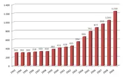
Traffic cost revenue
In 2018, the network had a traffic of 82.605.511 vehicles, including 72.996.584 light vehicles and 9.608.927 heavy vehicles ([6] difference by axle height).
The travel cost is near 7 euros per 100 km for light vehicles and 30 euros per 100 km for heavy ones.[6]
Those costs generate a revenue of 383.036.824 euros i 2017 and 406.154.835 in 2018.[6]
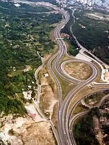
Expressways
There is a wide variety of types of expressways in Croatia, in terms of number of lanes, accessibility and types of intersections comprised. They range from four lane expressways with grade-separated intersections and limited access - distinguished from the motorways by lack of emergency lanes only - to four or six lane urban expressways with numerous at-grade intersections and traffic lights or two lane limited access roads with grade separated intersections. The expressways include both incomplete motorways, built in stages,[9] and some state roads (with either limited access, more than two traffic lanes, grade-separated intersections or any combination thereof). There are even some instances of county roads which may be regarded expressways such as Jadranska Avenue (Ž1040).
As a rule, the expressways are not tolled, however major tunnels on the expressways are tolled.
List of completed expressways
| Number | Control cities (or other appropriate route description) |
|---|---|
| sections through Karlovac[19] (four lane dual carriageway, with at-grade intersections) | |
| Dugopolje interchange (A1) - Split[20] (fourlane dual carriageway, with grade separated intersections) | |
| Osijek southern bypass[21] (four lane dual carriageway, with grade separated intersections) | |
| sections through and near Split[22] (four lane dual carriageway, with at-grade intersections) | |
| Sveta Helena interchange (A4) - Križevci[23] (four lane dual carriageway, with grade separated intersections) | |
| Vrbovec 2 interchange (D10) - Farkaševac[24] (four lane dual carriageway, with grade separated intersections) | |
| Zabok interchange (A2) – Zlatar Bistrica (D29) (two lane single carriageway, with grade separated intersections) | |
| Šibenik interchange (A1) - Šibenik (Vidici interchange)[25] (two lane single carriageway, with grade separated intersections) | |
| Zagvozd (Biokovo toll booth) - Baška Voda (D8) (two/four lane single carriageway with grade separated intersections) | |
| Bisko interchange (A1) - Čaporice (D60) (four lane dual carriageway/two lane single carriageway, with grade separated intersections) | |
| Draga interchange (A7) - Rijeka (Brajdica interchange) (three/four lane single carriageway, with grade separated intersections) | |
| Zadar 2 interchange (A1) - Zadar (Gaženica Port)[26] (four lane dual carriageway, with grade separated intersections) | |
| Karamatići toll station (A1) - Ploče (Čeveljuša interchange) (four lane dual carriageway/two lane single carriageway, with grade separated intersections) | |
| Gornja Ploča interchange (A1) - Udbina[27] (two lane single carriageway, with grade separated intersections) |
State roads
State roads are defined by legislation[2] as important routes for road traffic between various parts of the country. Classification of a road as a state road does not describe actual conditions of the road itself.
State roads in Croatia are assigned one, two or three digit numbers which generally comply with the following pattern[28] (although there are some exceptions to the rules):
- 1-19 are assigned to trunk roads, normally of considerable length, spanning between borders of various neighboring countries. An obvious exception to this is the D9 state road however it spans from Bosnia and Herzegovina border and the Adriatic Sea, along the southernmost portion of Pan-European Corridor Vc.
- 20-99 are assigned to arterial roads on the mainland.
- 100s are assigned to island roads
- 200s are assigned to border crossing access roads.
- 300s are assigned to junction roads, connecting towns or cities (but not other state roads) to motorways or other major roads. Notable exceptions to this are D307 and D310 state roads, although the D307 originally did not connect to the D29, but only to the A2 motorway.
- 400s are assigned to mainland port and airport access roads.
- 500s are assigned to connecting roads, connecting two different state roads. Notable exceptions to this rule are the D503 which connects to a port and the D516 which connects to a border crossing checkpoint.
At the moment the state roads in Croatia have a combined length of 6,867.7 kilometres (4,267.4 mi).
D1 - D14
| Number | Control cities (or other appropriate route description)[2] | Length |
|---|---|---|
| Gornji Macelj (A2) - Krapina - Zagreb - Karlovac - Gračac - Knin - Brnaze - Split (D8) | 418.66 km | |
| Dubrava Križovljanska border crossing (Slovenia) - Varaždin - Virovitica - Našice - Osijek - Vukovar - Ilok border crossing (Serbia) | 347.49 km | |
| Goričan border crossing (Hungary) - Čakovec - Varaždin - Breznički Hum - Zagreb - Karlovac - Rijeka (D8) | 218.44 km | |
| Terezino Polje border crossing (Hungary) - Virovitica - Veliki Zdenci - Daruvar - Okučani - Stara Gradiška border crossing (Bosnia and Herzegovina) | 123.12 km | |
| Jurovski Brod border crossing (Slovenia) - Ribnik - Karlovac - Brezova Glava - Vojnić - Glina - Dvor border crossing (Bosnia and Herzegovina) | 134.47 km | |
| Duboševica border crossing (Hungary) - Beli Manastir - Osijek - Đakovo - Slavonski Šamac border crossing (Bosnia and Herzegovina) | 115.21 km | |
| Pasjak border crossing (Slovenia) - Šapjane - Rijeka - Zadar - Split - Klek border crossing (Bosnia and Herzegovina) - Zaton Doli border crossing - Dubrovnik - Karasovići border crossing (Montenegro) | 643.40 km | |
| Metković border crossing (Bosnia and Herzegovina) - Opuzen - (D8) | 10.88 km | |
| Sveta Helena interchange (A4) - Dubrava - Gradec - Križevci - Koprivnica - Gola border crossing (Hungary) | 86.40 km | |
| Vrbovec 2 interchange (D10) - Bjelovar - Virovitica - Terezino Polje border crossing (Hungary) | 86.50 km | |
| Zabok interchange (A2) - Andraševec - Bedekovičina - Poznanovec - Zlatar Bistrica (D29) | 17.41 km |
D20 - D77
| Number | Control cities (or other appropriate route description)[2] | Length |
|---|---|---|
| Čakovec (D3) – Prelog – Donja Dubrava – Đelekovec – Koprivnica (D2) | 50.4 km | |
| D3 - Novi Marof – Križevci – Sveti Ivan Žabno | 42.7 km | |
| Duga Resa (D3) – Josipdol – Žuta Lokva – Senj (D8) | 103.9 km | |
| Zabok (D1) – Zlatar Bistrica – Donja Konjšćina – Budinšćina – Novi Marof – Varaždinske Toplice – Poljanec (D2) | 72.4 km | |
| Korenica (D1) – Bunić – Lički Osik – Gospić – Karlobag (D8) | 83.6 km | |
| Dubrava (D10) - Čazma - Garešnica - Dežanovac - Daruvar (D5) | 88.5 km | |
| Gračac (D1) - Obrovac - Benkovac - Stankovci - D8 | 96.9 km | |
| Gradec (D10) - Bjelovar - Veliki Zdenci (D5) | 70.7 km | |
| Novi Golubovec (D35) - Zlatar Bistrica - Marija Bistrica - Soblinec (D3) | 49.8 km | |
| Buzin interchange (A3) - Velika Gorica - Petrinja - Hrvatska Kostajnica border checkpoint (Bosnia and Herzegovina) | 83.1 km | |
| Velika Gorica (D30) - Gornji Viduševac - D6 | 56.1 km | |
| Prezid border checkpoint (Slovenia) - Delnice (D3) | 49.7 km | |
| Strmica border checkpoint (Bosnia and Herzegovina) - Knin - Drniš - Vidici (D8) | 73.3 km | |
| Slatina (D2) - Donji Miholjac - Josipovac (D2) | 79.0 km | |
| Varaždin (D2) - Lepoglava - Sveti Križ Začretje (D1) | 46.0 km | |
| Karlovac (D1) - Pokupsko - Sisak - Popovača (Ž3124) | 110.5 km | |
| Sisak (D36) - Petrinja - Glina (D6) | 34.4 km | |
| Pakrac (D5) - Požega - Pleternica - Đakovo (D7) | 120.7 km | |
| Bosnian Border - Aržano - Cista Provo - Šestanovac roundabout - Dubci (D8) | 37.3 km | |
| Sveti Kuzam interchange (A7) - D8 - Port of Bakar (West) | 3.1 km | |
| Gola border checkpoint - Koprivnica - Križevci (D22) | 82.9 km | |
| Vrbovsko (D3) - Ogulin - Josipdol - Plaški - Grabovac (D1) | 57.9 km | |
| Đurđevac (D2) - Bjelovar - Čazma - Ivanić Grad interchange (A3) | 78.1 km | |
| Nova Vas interchange (A9) - Ponte Porton - Buzet - Lupoglav interchange (A8) | 50.5 km | |
| Veliki Zdenci - (D5) - Garešnica - Kutina interchange A3 | 43.6 km | |
| Đakovo D7 -Vinkovci - Tovarnik border checkpoint (Serbia) | 73.0 km | |
| Lipik (D5) - Novska - Hrvatska Dubica - Hrvatska Kostajnica - Dvor (D6) | 94.5 km | |
| Baderna interchange (A9) - Pazin - Rogovići interchange (A8) | 20.8 km | |
| Pleternica - Lužani interchange (A3) | 19.2 km | |
| Žuta Lokva (D23) - Otočac - Gospić - Gračac (D40) | 104.2 km | |
| Gradište (D53) - Požega - Nova Gradiška interchange (A3) | 50.3 km | |
| Špilnik (D50) - Korenica (D1) | 41.1 km | |
| Donji Miholjac border checkpoint (Hungary) - Našice - Slavonski Brod border checkpoint (Bosnia and Herzegovina) | 91.6 km | |
| Maslenica (D8) - Zaton Obrovački D27 | 13.5 km | |
| Borovo (D2) - Vinkovci - Županja border checkpoint (Bosnia and Herzegovina) | 48.6 km | |
| Tromilja interchange (D424) – Benkovac – Skradin – Drniš (D33) – Muć – Klis–Grlo interchange (D1) | 119.6 km | |
| Vukovar (D2) - Orolik - Nijemci - Lipovac interchange A3 | 36.1 km | |
| Šibenik (port) - Boraja - Trogir (D8) | 43.0 km | |
| Knin (D8) - Kistanje - Bribirske Mostine - Putičanje - Kapela (D8) | 53.9 km | |
| Brnaze (D1) - Trilj - Cista Provo - Imotski - Vinjani Donji border checkpoint (Bosnia and Herzegovina) | 66.1 km | |
| Šestanovac (D39) - Zagvozd - Vrgorac - Kula Norinska - Metković (D9) | 89.5 km | |
| Pazin (D48) - Potpićan - Vozilići (D66) | 26.9 km | |
| Pula (D400) - Labin - Opatija - Matulji (D8) | 90.1 km | |
| Slatina (D2) - Čeralije - Voćin - Novo Zvečevo - Kamenska (D38) | 53.4 km | |
| Omiš (D8) - Naklice - Gata - Blato na Cetini interchange (A1) | 21.6 km | |
| Slavonski Brod: D53 - Svačićeva - I. G. Kovačića - N. Zrinskog (D423) | 2.7 km | |
| Đurmanec (D207) - Krapina - Bednja - Lepoglava (D35) | 22.0 km | |
| D200 - Savudrija - Umag - Novigrad - Poreč - Vrsar - Vrh Lima - Bale - Pula (D400) | 101.7 km | |
| Baško Polje (D8) – Zagvozd (D62) – Grubine (D60) – Imotski – Gornji Vinjani border checkpoint (Bosnia and Herzegovina) | 28.3 km | |
| Rogovići interchange (A8) – Žminj – Svetvinčenat – Vodnjan (D75) | 33.2 km |
D100 - D128
| Number | Control cities (or other appropriate route description)[2] | Length |
|---|---|---|
| Porozina (ferry port) - Cres - Mali Lošinj (Ž5159) | 80.5 km | |
| D100 - Merag (ferry port) | 10.9 km | |
| Šmrika (D8) - Krk - Baška | 48.3 km | |
| D102 - Rijeka Airport | 1.7 km | |
| D102- Valbiska (ferry port) | 10.1 km | |
| Lopar (ferry port) - Rab - Mišnjak (ferry port) | 22.7 km | |
| Žigljen (ferry port) - Novalja - Pag - Ražanac - Posedarje (D8) | 73.8 km | |
| Veli Rat - Savar - Sali | 41.9 km | |
| Muline (ferry port) - Ugljan - Tkon (ferry port) | 41.6 km | |
| Maslinica - Grohote - Stomorska | 17.8 km | |
| Rogač (ferry port) - D111 | 1.9 km | |
| Supetar - Nerežišće - Sumartin (ferry port) | 39.4 km | |
| Milna - Sutivan - Supetar (D113) | 18.8 km | |
| Gornji Humac (D113) - Bol | 11.4 km | |
| Hvar - Milna - Starigrad (ferry port) - Sućuraj | 77.8 km | |
| Komiža - Podhum - Vis | 19.9 km | |
| Vela Luka - Kapja - Dubovo - Korčula | 43.5 km | |
| Ubli - Lastovo | 9.5 km | |
| Pomena - Polače - Sobra - Saplunara | 42.9 km | |
| Murter - Tisno - D8 | 14.0 km | |
| Sobra (ferry port) - D120 | 1.1 km | |
| Brbinj (ferry port) - Brbinj - D109 | 1.7 km | |
| Zaglav (ferry port) - D109 | 1.1 km | |
| Trogir (D315) - Arbanija - Slatine | 8.3 km | |
| Uvala Mikavica - Žirje (ferry port) | 3.8 km |
Tolls
Tolls are charged on seven stretches of Croatian motorways, along with some other roads.[29]
There are two toll collection systems in Croatia: the open and the closed system. Open system is used on some bridges and tunnels and short stretches of tolled highway. In this system, there is only one toll plaza and drivers immediately pay the toll upon arriving.
Safety
Croatia had 73 road deaths per million inhabitants estimated in 2019.[30]
See also
Maps
- Overview map of the A1 (Map). OpenStreetMap. Retrieved December 14, 2012.
- Overview map of the A2 (Map). OpenStreetMap. Retrieved December 14, 2012.
- Overview map of the A3 (Map). OpenStreetMap. Retrieved December 14, 2012.
- Overview map of the A4 (Map). OpenStreetMap. Retrieved December 14, 2012.
- Overview map of the A5 (Map). OpenStreetMap. Retrieved December 14, 2012.
- Overview map of the A6 (Map). OpenStreetMap. Retrieved December 14, 2012.
- Overview map of the A7 (Map). OpenStreetMap. Retrieved December 14, 2012.
- Overview map of the A8 (Map). OpenStreetMap. Retrieved December 14, 2012.
- Overview map of the A9 (Map). OpenStreetMap. Retrieved December 14, 2012.
- Overview map of the A10 (Map). OpenStreetMap. Retrieved July 7, 2013.
- Overview map of the A11 (Map). OpenStreetMap. Retrieved December 14, 2012.
References
- Croatian Parliament (2004-12-18). "Zakon o javnim cestama (Public Roads Act)". Narodne novine (in Croatian). Retrieved 2010-06-28.
- "Odluka o razvrstavanju javnih cesta" [Decision on categorization of public roads]. Narodne novine (in Croatian) (17/2020). January 30, 2020. Retrieved January 2, 2021.
- Ministry of Sea, Transport and Infrastructure (Croatia) (2003-05-06). "Regulation on markings of motorways, their chainage, interchanges and rest areas". Narodne novine (in Croatian). Retrieved 2010-06-28.
- Croatian Parliament (2008-06-09). "Zakon o sigurnosti prometa na cestama" (in Croatian). Narodne novine 2008-67. čl. 2, t. 1, st. 3. Retrieved 2010-06-28.
- "Motorways network". huka.hr. Croatian Association of Motorway Concessionaires (HUKA). 2016. Retrieved 2016-06-28.
- http://www.huka.hr/en/news/328-huka-published-the-national-report-on-motorways-for-the-year-2018
- "Odluka o razvrstavanju javnih cesta u autoceste" [Decision on classification of public roads as motorways]. Narodne Novine (in Croatian). July 25, 2007. Retrieved October 18, 2010.
- "Odluka o izmjenama i dopunama odluke o razvrstavanju javnih cesta u autoceste" [Decision on amendments and additions to the Decision on classification of public roads as motorways]. Narodne Novine (in Croatian). January 30, 2009. Retrieved October 18, 2010.
- "Regulation on motorway markings, chainage, interchange/exit/rest area numbers and names". Narodne novine (in Croatian). April 24, 2003. Archived from the original on October 4, 2011. Retrieved August 19, 2010.
- "KLJUČNE BROJKE" (PDF). HUKA. May 2019. ISSN 1848-0993. Retrieved 17 November 2019. Cite journal requires
|journal=(help) - "After completing the bridge across the Drava, the works were completely moved to the Baranja side". Glas Slavonije (in Croatian). July 21, 2018.
- "Cornerstone for the bridge Svilaj". Poslovni dnevnik (in Croatian). September 14, 2016.
- "Počinje izgradnja punog profila od Pazina do Tunela Učka (video)". istarski.hr (in Croatian). 15 November 2018.
- "Plan građenja i održavanja autocesta za 2015. godinu" (PDF) (in Croatian). Croatian Motorways. p. 9. Archived from the original (PDF) on 16 March 2015. Retrieved 12 June 2016.
- "Public roads construction and maintenance program 2009 - 2012" (PDF). HUKA (in Croatian). December 11, 2009. Retrieved September 6, 2010.
- "Plan gradnje punog profila autoceste" [Full profile motorway construction plan]. BINA Istra. 2015. Archived from the original on August 15, 2016. Retrieved June 28, 2016.
- in 2015 or latest available year
- https://ec.europa.eu/transport/road_safety/sites/roadsafety/files/pdf/statistics/dacota/bfs2017_motorways.pdf
- "The works must be finished by touristic season or suspended". Večernji list (in Croatian). April 9, 2010.
- "Solin-Klis expressway opened after 26 years of construction: It cost 55 million per kilometer". www.index.hr (in Croatian). December 14, 2014.
- "Southern bypass opens". portal Osijek031 (in Croatian). November 5, 2015.
- "Trogir - Omiš expressway construction resumed". Nova TV (in Croatian). November 6, 2006.
- "Minister Oleg Butković opened expressway Gradec - Križevci". hac.hr (in Croatian). Hrvatske autoceste. 2 September 2016. Retrieved 2 September 2016.
- "Expressway between Vrbovec and Farkaševac is open". HRT Vijesti. 16 April 2019. Retrieved 1 September 2019.
- "Šibenik - Drniš - Knin - Bosnia and Herzegovina border expressway". Građevinar (in Croatian). March 28, 2008.
- "Kalmeta officially opens Zadar 2 - Gaženica four lane expressway". eZadar (in Croatian). November 6, 2007. Archived from the original on May 22, 2011. Retrieved August 19, 2010.
- "Dalmatina opens gates of Dalmatia". Slobodna Dalmacija (in Croatian). July 1, 2003.
- Ministry of Sea, Transport and Infrastructure (Croatia) (21 April 2015). "Pravilnik o sadržaju, ustroju i načinu vođenja baze podataka o javnim cestama i objektima na njima". narodne-novine.nn.hr (in Croatian). 4.2 Evidencijske oznake državnih cesta.CS1 maint: location (link)
- "Driving in Croatia". RAC. Retrieved 29 May 2019.
- https://ec.europa.eu/commission/presscorner/detail/en/qanda_20_1004
External links
| Wikimedia Commons has media related to Highways in Croatia. |