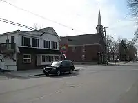
Historical buildings and structures of Yarmouth, Maine
The historical buildings and structures of Yarmouth, Maine, represent a variety of building styles and usages, largely based on its past as home to almost sixty mills over a period of roughly 250 years. These mills include that of grain, lumber, pulp and cotton.[1] Additionally, almost three hundred vessels were launched by Yarmouth's shipyards in the century between 1790 and 1890, and the homes of master shipwrights and ship captains can still be found throughout the town.[2]
Yarmouth's 2010 Comprehensive Plan identified "historic character" as one of five key topics facing the town. The Plan proposed policies and strategies to ensure that "buildings of historic significance will be maintained while allowing the buildings to be improved, modernized and expanded."[3]
In 2017, the town hired Historic Building Consultant Margaret Gaertner to conduct a historic architectural survey of the Village area of Yarmouth. This was completed in September 2018.[4]
The Maine Historic Preservation Commission[5] has found many of Yarmouth's historic buildings eligible for listing on the National Register of Historic Places,[4] in addition to the twelve that are already included.
In December 2017, the first phase of a "reconnaissance-level architectural survey" of the town's "village core" was commissioned by its Department of Planning & Development. The surveyed structures, across 773 acres, included houses, barns, churches, bridges, dams "and objects such as memorials and water troughs."[6]
In 2019, the town began to develop a historic preservation ordinance, with proposed historic district boundaries, regulations and guidelines. The three potential historic districts that were recommended were Upper Village, Lower Village and Royal River Manufacturing Company.[3]
National Register of Historic Places
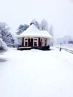
In 2018, Yarmouth adopted a Demolition Delay ordinance, which prohibits demolition of properties on or eligible for listing in the National Register of Historic Places.[7] Twelve properties in Yarmouth are currently listed on the Register.[8] The oldest (the Cushing and Hannah Prince House) dates from 1785; the "newest" (the Grand Trunk Railway Station) was built in 1906, replacing a structure built in 1848. They are ranked in chronological order below.
- Cushing and Hannah Prince House, 189 Greely Road
- North Yarmouth and Freeport Baptist Meeting House, 3 Hillside Street
- Ammi Mitchell House, 333 Main Street
- Russell Hall, North Yarmouth Academy, 129 Main Street
- Academy Hall, North Yarmouth Academy, 129 Main Street
- Capt. S. C. Blanchard House, 317 Main Street
- Captain Reuben Merrill House, 233 West Main Street
- First Universalist Church, 97 Main Street
- First Parish Congregational Church, 116 Main Street
- Camp Hammond, 275 Main Street
- Cousins Island Chapel, 414 Cousins Street
- Grand Trunk Railway Station, 288 Main Street
In 2018, a further 46 properties older than fifty years were identified as being potentially eligible for individual listing.[6]
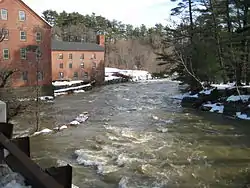
Lower Falls
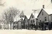
Also known as the First Falls, Lower Falls was the location of several mills from the 17th century onward, while — on the southern side of the bridge — were the yards where many hundreds of ships were built and launched between 1740 and 1890.
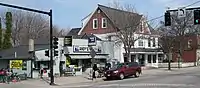
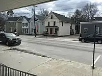
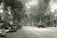
Main Street
19th- and 20th-century homes and business that existed on Main Street in Yarmouth's Lower Falls (also Falls Village or The Falls) section are listed below, roughly from east to west.[2]
Nicholas Grant built the main building of the since-expanded Greek Revival house at 37 Main Street, on the hill down to the harbor, around 1844.[4]
Henry Rowe (b. 1812, d. 1870)[9] was the architect of the pink Gothic Revival house at 49 Main Street, which was built in 1845.[4] Rowe also designed The Gothic House in Portland.
50 Main Street, the three-story old Hose No. 2 at the Main Street and Marina Road split, was built for the fire department around 1889.[4]
Back on the northern side of the street, number 57 was built around 1813.[4]
Next door, number 63, was built around 36 years later, in 1849.[4]
76 Main Street, set back from the road, adjacent to Torrey Court, was built in 1792. The home has six bedrooms, five bathrooms, and sits on 1.6 acres.[4]
73 Main Street, whose left side faces the street, was once the home of Jacob G. Loring.[4]
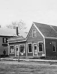
In the building at 82–84 Main Street was W.N. Richards & Co. (owned by William Richards); in the 1960s Vining's delicatessen[4] and, beside it to the west, George Soule's ice cream shop and pool hall.
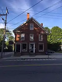
Across the street, the brick building at 85 Main Street currently occupied by Svetlana was erected around 1848.[4]
90 Main Street, built in 1875,[10] was Barbour's hardware store; later Goffs hardware (1969–2015).
Manley E. Bishop's grocery store stood to the east of the present-day Goffs building.
Englishman James Parsons' grocery store, "a two-story building standing on the lot adjoining that where stood for so many years the little old post office".[11] It was here that "dignified citizens like Doctor Bates, L.L. Shaw and Barnabas Freeman often assembled for an evening's chat".[11] Parsons arrived in town around 1860 and married a very wealthy local woman.[2]
The post office until around 1905. The first postmaster was Payne Elwell (b. 1744, d. 1820) in 1793. (He lived in the building that is now 162 Main Street, which stands on the former site of the Knights of Pythias Hall.) He was succeeded in 1803 by Samuel P. Russell, David Drinkwater in 1804, John Hale in 1810, Daniel Mitchell in 1816, James C. Hill in 1834, Jacob G. Loring in 1842 and Reuben Cutter in 1845.[4] When the town split occurred, the office name was changed in 1852 to Yarmouth from North Yarmouth. Reuben Cutter resumed the role, and was followed by Otis Briggs Pratt in 1861 and Nicholas Drinkwater in 1866. Lucy V. Groves was appointed in 1868, becoming the first woman named or elected to an official position in the town of Yarmouth. Lucy Q. Cutter succeeded her in 1887, Melville C. Merrill in 1898, Frank Howard Drinkwater in 1911, Frank O. Wellcome in 1914 and Ernest C. Libby in 1936.[1]
Cornelius Shaw's Cash Market (1899). The plural version, Shaws', appeared on the sign, meaning it was a family business.
At today's 91 Main Street is the former Captain Thomas Chase Store, built around 1819.[4] Between 1895 and 1929 it was Leon Doughty's stove and hardware store, L.A. Doughty & Co. It is now Snip 'N Clip Hair Designs, still with the windows that were installed in 1932. Doughty moved across the street, into the building to be later occupied by L.R. Doherty's hardware store, Barbour's and Goffs, when his business expanded.
William Freeman's hairdressing salon (located above Doughty's before its move). Freeman lived on Lafayette Street. He had at least two children: William and Jennie.
Cyrus Curtis' Saturday Evening Post publishers.
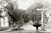
The millinery shop of Susan Kinghorn (located at the eastern corner of Main and Portland Streets in the building now occupied by Rosemont Market); between 1942 and 1953 [Harold B.] Allen's Variety Store, then Daken's, Romie's, Lindahl's, Donatelli's Pizza, Denucci's Pizza (briefly) and Connor's.
Elder Rufus York's general store (located in the brick building now occupied by Runge's Oriental Rug store at 108 Main Street, on the western corner of the Portland Street intersection; later William Hutchinson Rowe's, then Melville Merrill's, then Frank W. Bucknam's Pharmacy (1894–1900). Bucknam was appointed as Maine's Commissioner of Pharmacy in 1906. He entered the drug business as an apprentice with Leone R. Cook. After running his own store for six years, he purchased a store in Skowhegan. His new business was destroyed by fire in 1904, but he was back in business in a temporary store within 36 hours. He eventually found a new home beneath the Oxford Hotel at 78 Water Street. This building too burned down, in 1908.[12][13] The Yarmouth building became Roger Vaughan's Rexall Pharmacy from 1945 to 1963. (Vaughan's original sign was restored to the Portland Street corner of the building in 2014 but was taken down the following year). York ran the general store with his wife, Zoa.
In 1874, the Lower Falls near the harbor was crowded with the homes of sea captains, merchants and shipbuilders.[14]
An ornate, circular horse trough resembling a water fountain existed at the intersection of Main and Portland Streets in the early 1900s;[15] it now stands behind the Merrill Memorial Library.
The parsonage for the Universalist church was the brick building at 89 Main Street, now occupied by Plumb-It, et al, to the east of Snip 'N Clip.[16] It was built around 1845 by Bradbury True, whose sons owned the neighboring houses.[4]
95 Main Street, a high-style Italianate,[4] is now owned by the First Universalist Church.
On the other side of the church, at number 109, just to the east of where Old Sloop (later known as Union Hall) once stood, is an 1850-built Italianate house that was formerly the home of Edward J. Stubbs, one of Yarmouth's most prolific and successful shipbuilders.[17]
Lyman Walker (b. 1814, d. 1906) and his son, Lyman Fessenden Walker, owned a general wood and coal business in the lower village.[18]
124 Main Street, which faces the Bridge Street intersection, is the circa-1825 John Sargent House.[4] Next door, at number 128, is a 1925-built house now used as the NYA admissions office.[4]
Bridge Street
Bridge Street crosses the Second Falls at the Sparhawk Mill. It connects to Main Street to the south and Willow Street to the north.
17 Bridge Street was built in 1852 and used as the parsonage for the First Parish Church between 1862 and 1997.[4] Meanwhile, 21 Bridge Street was built in 1851 as a duplex for mill owners Mitchell and Loring.[4]
The original wooden 1811 NYA school building was removed to the adjacent Bridge Street "just below the residence of the late Charles O. Rowe, the father of William Hutchinson Rowe,[1] roughly where number 28 Bridge Street, built in 1860, is today.[19]
43 Bridge Street was built in 1844 and became part of Royal River Manufacturing Company in 1871.[4]
Sparhawk Mill is at number 81. This brick mill was built in the 1840s, replacing a wooden mill dating to 1817, but its top half was rebuilt in 1855 after a fire.
Crossing the river, directly across from the Sparhawk Mill tower is 80 Bridge Street, which was built as the office for the above business in the early 1880s. Its architect was Francis H. Fassett.[4]
The 1840-constructed former home of George G. Loring, built by Phillip Kimball,[6] stands on the hill overlooking the falls at 100 Bridge Street.[4]
Boarding houses, which still exist today at 107 and 109 Bridge Street, were built in 1890 on the crest of the northern Bridge Street hill, providing accommodation for weavers, seamstresses and bobbin boys of the mills.
In 1848, mill-owner Philip H. Kimball built the house at 125 Bridge, which is today's Charron residence.[4]
Number 132 was built in 1840.[20]
The run-down building at 148 Bridge (at its intersection with Willow Street) has been vacant since the early 2000s. It was built in 1826.[4]
East Main Street
East Main Street (which changes from State Route 115 to State Route 88 here) crosses the bridge at the First Falls and has been a route to the northeastern part of Yarmouth (and into Freeport) since the founding of the town.
35 East Main Street was built in 1848. Its brick basement was once used as a store. Shipbuilder Jeremiah Baker lived here between 1857 and around 1871.[4]
38 East Main Street was built by shipbuilder Albion Seabury in 1844.[4] Directly opposite, number 43 was originally owned by Jonathan True in 1780, a clothier who owned a store at Lower Falls. It was later associated with Dr. David Jones[4] and David Pratt, one of Yarmouth's earliest shipbuilders.[6]

Number 49 was moved here in 1817 by Major Daniel Mitchell and later expanded by Daniel L. Mitchell. As of 2018, the nine-over-six windows, entry door and surround, trim and siding are all original.[6]
51 East Main Street was built in 1810 and was once the home of William Stockbridge, a prominent merchant, ship owner and town treasurer. It operated as the main building of the Royal River Cabins until the 1940s.[4]
Number 56 was built, likely by clockmaker Lebbeus Bailey, in 1792. It was also associated with Albion Seabury.[4] Next door, at 64 East Main, is a home built by Augustus True in 1865.[4]
Number 68, at the corner of East Main and Yankee Drive, was built in 1780 by Peter Weare, a sawmill and gristmill owner. It has also served as a tavern, a general store and, between 1900 and 1907, a girls’ school.[4]
Close to the East Main and Spring Street split, number 96 was likely built by Samuel Buxton and later occupied by Nathaniel True.[4]
100 East Main Street was built in 1810. Around twenty years later it became Asa Bisbee’s blacksmith shop.[4] Next door, number 112, was built by Jacob Jones around 1818.[4]
Just beyond the junction with Willow Street stands number 129, which was built by Madison Northey around 1865.[4]
Samuel Kinney lived at number 148 around 1813.[4] It was built in 1810.
High Street
High Street, a cul-de-sac, is off the northern section of Portland Street. Rocky Hill Road runs from the end of High down to Marina Road.
Shipbuilder Elbridge Hutchins lived at 5 High Street, which was built in 1900.[4]
73 High Street, built in 1868, was the home of John R. Gooding.[4]
85 High Street was built by Solomon Sawyer in 1877 and remained in his family until 1984.[4]
Lafayette Street
Lafayette Street is what State Route 88 becomes upon its entry to Yarmouth from Cumberland Foreside. It was originally known as Atlantic Highway.
28 Lafayette Street, which stands beside the stone marker honoring Walter Gendall, was built in 1750 according to one source or, according to another, in the 1920s.[4]
Across the street at number 33, Reed's Machine Shop was built in 1927. It has been owned and run as the current business since 1973 by Stephen Welch.[21]
Marina Road
Marina Road is the right-hand turn at the Staples Hill split with Main at East Main. It was one of the two access roads to the harbor from Main Street.
Original owner Peter Allen tore down the Hannah Russell House at 3 Marina Road and built the current structure in 1881.[4] Until 2018 it was home to the business Women to Women.
Herman Seabury, a shipyard foreman, was the original owner of 9 Marina Road in 1890. It remained in his family for sixty years.[4]
Number 22 is believe to date from around 1800.[4]
The last building on Marina Road before the Lafayette Street intersection is number 59. Built in 1900 by Harry Dean as a tea room, it later became a shoe-repair shop, an antique store and an office.[4] It is now a nutritionist business.
Pleasant Street
Originally where the Atlantic Highway continued from today's Route 88 out of Cumberland Foreside, and part of the route of the trolley cars of the Portland and Yarmouth Electric Railway Company's runs at fifteen-minute intervals. It was also the access road to the wharves before the Lafayette Street hill was paved. Several people pertinent to the shipbuilding industry lived on Pleasant Street, including Captain William Gooding.
Shipbuilder Giles Loring lived at the 1840-built number 35.[4]
The original owner of number 44, which was built in 1860, was a ship captain.[4]
Daniel M. Stubbs built the circa-1859[6] number 50. It was purchased in 1864 by photographer Charles Gustavus Gooding.[4]
Several notable members of Yarmouth's seafaring past have lived in the brick number 51, which was built in 1831: mariner Enos Chandler, master shipwright Lyman Fessenden Walker and Giles Loring.[4]
William Gooding Jr. built number 68 around 1846. It remained in the family for 103 years.[4]
The cape at number 71 was built in 1750.[22]
Number 85's original owner, in 1848, was yeoman and shipbuilder Henry Hutchins.[4]
Shipbuilder William Gooding lived across the street at the 1843-constructed number 86.[4]
Number 97, built in 1846, is a well-preserved Greek Revival. Its door surround, entablatures at the windows, pilasters and cornice make it eligible for listing.[6]
Built in 1730, 112 Pleasant Street is believed to be one of the oldest homes in Yarmouth.[4]
The cape at number 125 is a well-preserved, high-style Greek Revival with details including an entry surround with a tablet and sidelights. It also has an attached barn.[6]
Penelope Seabury lived in the cape at number 135, which dates from 1830.[4]
The home at 166, at the inside of the curve down to Lafayette Street, is believed to have been built around 1844.[4] Meanwhile, number 242, the final home on the right before Lafayette Street, was built in 1836.[4]
Gooding's End
At the apex of the Pleasant Street corner is Gooding's End, named for the family involved in shipbuilding down at the harbor.
Henry Gooding lived at number 7, built in 1874.[4]
Number 25, built in 1840, was originally part of the Royal River Cabins on Route 88. It is believed this cabin was the one Eleanor Roosevelt stayed in when in Yarmouth in the 1940s.[4]
Portland Street
The northern (village) end of the street is the historic part. The southern section, across Route 1, eventually leads to Portland.
The former District Number 3 schoolhouse still stands at number 12 Portland Street. It was the superintendent's office for several years. Its original architect was Francis H. Fassett.[4]
Ammi Storer, the original owner of a business in the brick building at the corner of Main and Portland, lived at number 17. He built the house around 1867.[4] Shoemaker Tristram Cleaves lived next to the schoolhouse at number 18, which was built in 1840.[4]
In an 1875 photograph of the northern end of Portland Street, with the Universalist church in the background, Englishman Captain Henry Newton's house (number 34, built in 1856) is visible on the right.[23] Dr. William Parsons[24] and painter Gad Hitchcock previously lived there. Leon Gorman, the grandson of Leon Leonwood Bean, also lived here until his death at the age of 80. He was, at the time of his passing, the wealthiest person living in the state of Maine, having had a reported net worth of $860 million.[25][26]
The original owner of number 23, which was constructed in 1850, was a blacksmith.[4]
Number 29, including its barn, is eligible for listing as an example of well-preserved Greek Revival design.[6]
Reuben Cutter, a shoemaker and postmaster, was the original owner of number 37 around 1839.[4]
Another blacksmith, Dexter Hale, was the original owner of number 47 in 1838.[4]
At number 61 (near the intersection with High Street), is the 1833 Federal-style cape that was owned by Davis Moxcey, a local shipwright in the early years of shipbuilding.[4]
Halfway along this northern section of Portland Street, at number 115, is a three-story Federal-style building that was once a tavern, built around 1810 by Colonel Seth Mitchell. It was later occupied by Deacon John Webster, in 1820, and Captain Eben Lane and his son-in-law Irving True. Lane ran it as a tavern from around 1857 until after 1871.[4] After 1915, Ralph Redfern used the property for a dairy that became known as Old Tavern Farm.[23]
Number 159, the last house on the right before the gas station, is a cape with high-style Greek Revival details, including oval windows framed with garlands set in the cornice. It is eligible for listing "due to its architectural merit."[6]
Storer Street
Off the northern end of Portland Street, Storer Street runs behind the First Parish Church. It is named for Ammi Storer, who was the first to run a business in the brick building at the corner, next to the church.
Number 23 was originally the home of papermaker William Hawes in 1850. The house was moved from Main Street around 1867 when the church was built.[4]
Brickyard Hollow
The section of town between the Upper Village and Lower Falls was known as Brickyard Hollow, named for the brick-making business that was located across the street from the Masonic Hall (now the restaurant Gather) at 189 Main Street,[6] which was built in the 1870s.
A muddy valley up until the beginning of the 20th century, the Hollow was eventually reclaimed as a civic center by laying down a two-foot layer of black ash, from Forest Paper Company, to level it out. After constructing two new schools, the Merrill Memorial Library and a war memorial, town officials also decided to rename the area Centervale in order to improve its image. The name did not last, however.[27]
Main Street
Sylvanus Blanchard lived in the brick building at 158 Main Street around 1847, before moving to number 317. As of 2018, the original barn is still attached.[6]
The cape at 163 Main Street was built around 1843.[4] 171 Main Street, on the eastern corner of the York Street intersection, dates from about the same year.[4] Across the intersection, at 179 Main Street, is a Greek Revival cape built in 1842.[4]
A lithograph from 1851, depicting the area of Main Street serviced by York Street, shows the home of George Woods and, next door, the Yarmouth Institute, which he established as direct competition with North Yarmouth Academy. Although it attracted students from as far afield as Cuba, his institute lacked an endowment and closed after five years. Woods sold the building to Paul Blanchard in 1853. It was torn down in 1930. In 1859, while serving in his new role as chancellor of the University of Pittsburgh, a lawsuit involving his dispute with NYA precipitated the split in Yarmouth's First Parish Church.[28]
In 1890, Yarmouth built a large new school building on the site of the present, 1975-built town hall and police station. Grades 5 to 8 were on the first floor; the high school occupied the upper level.[29] A three-story high school was constructed next to this in 1900. When all of the high-school students were sent to North Yarmouth Academy in 1930, the building became another elementary school. In 1974, both buildings were demolished to make way for the current construction.[29]
In 1903, six years before his death at the age of 76, Joseph Edward Merrill donated the funds to build a new library. The architect was Alexander Longfellow, a nephew of the poet Henry Wadsworth Longfellow. Also involved in the library's construction was John Coombs, father of George and Albert. Despite the occasional flood, town offices were eventually established in the library's basement.[30] The flooding was partly caused by the blockage of Cleaves Brook (where today's police station is) — which formerly drained the whole center of town — when Brickyard Hollow was filled in.
Directly across the street from the library stood the Dumphy house and barn. These were auctioned off in 1921, creating more public space in Centervale.[31]
In 1904, the town's Civil War veterans sought permission to place a soldiers monument in front of the new schools. With funds lacking, it was put off until after World War I (during which 106 Yarmouth residents served),[32] when the project was completed in tandem with a board of trade plan to erect a bandstand. The resulting octagon structure, in the Doric order, was adorned by a plaque to the veterans. The words "Memorial To Men of Yarmouth in War Service" appeared just below the roof line. The structure was inadequately maintained, however, and had to be removed when rotting boards resulted in injuries.[33]
In 1929, a new centralized post office was built to the east of the present 1932-dedicated Anderson-Mayberry American Legion Hall (named for servicemen Edgar Anderson and Edwin Mayberry, who died from the Spanish flu while based at Fort Devens).[2] On the left side of this building was the Fidelity Trust Company. The bank failed early in the Great Depression of the 1930s.[34] To the east of the post office stood the Knights of Pythias Hall.[34] It became the Pastime Theatre in the 1920s, then Yarmouth Theatre between 1942 and 1956. Harriman's IGA Foodliner moved here in the late 20th century from its Main and West Elm Streets location. A KeyBank (formerly Casco Bank) and the parking lot for NYA's Priscilla Savage Middle School now stand in its place.
During the middle of the 20th century, in the plaza across Cleaves Street that formerly housed a 7-Eleven and, until 2017, Anthony's Dry Cleaners & Laundromat, was the Dairy Joy ice-creamery, in front, and the Korner Kitchen (formerly the Snack Shack) behind it.
Across the street, at the intersection of Main and School Streets (in the building filled by People's United Bank), the post office occupied its final location before its move to Forest Falls Drive.
Ship owner Cyrus Foss Sargent's home stands at 251 Main Street. It ran as the Village Inn between 1916 and 1920.[4]
In 1867, the building at 261 Main Street (across from Hancock Lumber) was built for Sylvanus Cushing Blanchard. Later owners of the house include Joseph Hodsdon, proprietor of Hodsdon Shoe Company, and Dr. Fiore Agesilao Parisi.
273 Main Street, which stands at the entrance to Camp Hammond, is a "highly-altered former church" built in 1880.[4]
On January 2, 2009, twenty-six businesses located at 500 Route 1 were destroyed in an arson attack. The entire block, located near to the point at which Route 1 passes over Main Street, was pulled down shortly thereafter. Damage was estimated to be between $2 million and $4 million. Everett Stickney, of Exeter, New Hampshire, was convicted of starting the fire, along with another one in York, Maine, later that evening.[35] On November 12, 2009, Stickney was sentenced to an eleven-and-a-half-year prison term and ordered to pay $3.7 million in compensation.[36] The building was replaced in 2008 and several businesses have moved in.
School Street
School Street, which runs beside and behind the library, takes the motorist on and off Route 1 South.
In 1889, Dr. Herbert Merrill had a dental practice in the rear of his house, built four years earlier, in Brickyard Hollow on Main Street. It has since been moved to 26 School Street.[37] It is the building now occupied by InSight Eyecare on the InterMed campus.
York Street
York Street takes the motorist on and off Route 1 North.
Number 17 dates to around 1852, while number 22 was built around 1850.[4]
Upper Village
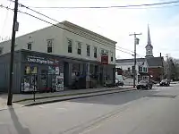
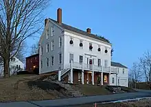
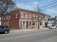
In contrast to today, people who lived near "the Corner" of Elm and Main Streets in the 19th century would not think of shopping at the Lower Falls end of the latter thoroughfare. For over 150 years, much of the retail activity in the Upper Village occurred in the area of the old brick stores at 355–359 Main Street. Some of the oldest buildings on Main Street are those on its southern side, clustered between the Catholic and Baptist churches.[39] The Daniel Wallis house at 330 Main Street, for example, was built around 1810.[39] Around the middle of the 19th century, Captain Cushing Prince, Jr. (b. 1786, d. 1869)[40] moved here from his historic house on Greely Road.[39]
Main Street
Businesses and residences in the Upper Village and the area around the intersection of Main and Elm Street, which officially became known as Yarmouthville in 1882, are listed below, roughly from west to east.
A house that stood at the corner of Main and East Elm was moved to 45 Baker Street around 1890.[4]
In the mid-to-late 1870s, diagonally across from where Handy Andy's now is, was Jeremiah Mitchell's "Temperance House"[41] tavern. Mitchell died in 1869, aged about 31. The inn's location later became the site of Wilfred W. Dunn's house, then, between 1959 and 1972, Norton's Texaco gas station. It is now Latchstring Park.[42]
After his death in 1811, the family of Dr. William Parsons moved into a colonial home, built around 1790 by its first occupant, Ebenezer Corliss, where the single-story building now stands at the corner of Main and West Elm Streets. The house was torn down in 1950.[43] The existing building, at 366, constructed in 1945 but since widened, formerly housed a pool hall, Edgar Read Smith's grocery store, Harriman's IGA Foodliner, and Turner's Television sales and service business.
Sam York's grocery store, located to the east of the Parsons residence, was built in 1890. Like the Parsons' residence, it too is now gone.[43]
Adelaide Abbott's millinery shop, located to the east of York's.[43]
The building that housed George H. Jefferd's harness shop (today's 358 Main Street) was built in 1890.[43] Isaac Johnson's barbershop was located above Jefferd's.[43]
The post office,[43] opened in May 1882. Its first postmistress was W.L. Haskell, followed by Joseph Raynes in 1886. He remained in the position for 28 years, leaving the post in 1914 to Beecher True Lane. Anna Tibbetts Douglass followed in 1919. This branch was closed in 1928, and a village carrier system began at the central office.[1]
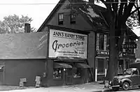
At the corner of Main and East Elm Streets stood a nail mill in 1807. (East Elm Street was known for a period as Mill Street, before today's incarnation was given its name.) In 1891, what was then Nathaniel Foster's pottery was torn down, after about fifty years in existence, and a new building was constructed. Since then, more than thirty different business or owners have set up here, including, between 1906 and 1935, Arthur and Harry Storer's hardware store, Storer Bros.[44] It was later John Ambrose Griffin's hardware store,[45] and became Andy's Handy Store – named for original proprietor, Leland "Andy" Anderson. In 1935, a 31-year-old Anderson combined the two wooden buildings of Griffin's and an adjacent grocery store (which sold produce "at Portland prices").[45] Now named "Handy's", it became occupied by OTTO Pizza in 2014.[46]
William Marston's dry goods store (founded in 1859; closed circa 1968).[47]
Located next door to Marston's was Leone R. Cook's apothecary, where Frank Bucknam was an apprentice.[47]
Harold Roy "Snap" Moxcey's barbershop, which he ran with his father Clarence ("Pop"), was located at the corner of Main and Center Streets, across Center Street from the Baptist church.[48] The building was moved around 1990 and now stands on the property of 463 Lafayette Street, across from the Ledge Cemetery.[4] Ernest C. Libby was an employee with the Moxceys for thirteen years before opening his own barber shop on Center Street.
To the right of the barbershop was Claude Kingsley's candy-distribution business.
A barber shop, beside the Baptist church, was owned by Charlie Reinsborough.
The Italianate number 347 is significant for its association with Captain Richard Harding, a sea captain, town clerk and state representative.[6]
343 Main Street was the home of Smith's General Store for "much of the 1900s". It also had a couple of American Oil Company gas pumps just off the sidewalk.[49]
339 Main Street was the home of local miller Amassa Baker, built in 1800.[4]
Coombs Bros. (Albert and George) candy and grocery store (located at 298 Main Street in the building between Railroad Crossing and South Street in a different construction than what is standing today). Bert set up the town's telephone service in 1895.[32] Elmer Ring's "washerette" later stood in the Coombs location, and it was he who changed the roofline and façade of the building. He also ran a hardware store, a heating and plumbing service, and a coal yard. In 2020, the town gave permission for developers to tear down the historic building.[50]
Captain Eben York's mansion at 326 Main Street (occupied since 1910 by the Parish Office of the Sacred Heart Catholic Church next door).[6] Father Joseph Quinn held services in the barn until it burned in 1913.[51]
Where Peachy's Smoothie Cafe stands today at 301 Main Street was, from 1905 until 1913, Bernstein's Department Store. Robert Bernstein, born in Germany, saw his business burn down in July 1913.[52][32] He reopened the store in a new location across the street.
St. Lawrence House – a hotel built, where the Mobil gas station near Camp Hammond stands today, to take advantage of the Atlantic and St. Lawrence Railroads coming through town. Circa 1872, it was renamed the Baker House, after its owner Jeremiah Baker (he previously lived at what is now 35 East Main Street, overlooking his shipyard, between 1857 and around 1871).[4] It was the first of several name changes, including Royal River Hotel (when owned by O.E. Lowell in the late 19th century),[18] U.S. House, Westcustogo House and Yarmouth Hotel.[32] The expected tourists never materialized, and the hotel burned down in 1926.[47] Grange Hall stood behind the hotel. Lowell Hall was in the second story of the stable.
J.O. Durgan's daguerreotype salon (located just to the east of the hotel; later Gad Hitchcock's coffin and casket showroom).
Alson Brawn's jewelry shop (at what was then 73 Main Street; formerly Sidney Bennett's Yarmouth Market, now Hancock Lumber).[48]
309 Main Street, at the eastern corner of Mill Street, is an 1850s–1880s house.[4]
An elm tree in front of Marston's store had a bulletin board nailed to it, upon which local residents posted, as early as 1817, public notices, circus posters and satirical comments about town affairs.[47] Like almost all of Yarmouth's elms, it became afflicted by Dutch elm disease and was cut down in 1980.[47]
Baker Street
Baker Street, near the Baptist Meeting House, connects Church and Cumberland Streets.
Number 22, a cape with a central chimney, is believed to have been moved from near 233 West Main Street. It was on its current site by 1859.[4]
Number 40 dates to 1850. It is the former home of John L. Lovell.[4]
Number 45 was moved from the corner of Main and East Elm around 1890. It was built at its original home in 1825.[4]
Center Street

Center Street is off the southern side of Main Street and connects to Cumberland Street. It was formerly known as Woodbury's Lane.
Another barber shop, Larry's, stood on Center Street.
20 Center Street is the home of Winslow Station, which served as the town's only fire station from 1953 until the mid-1990s. It was used by the fire department until 2004.[4] The building, which was constructed in 1930, is dedicated to Carl H. Winslow, who was the fire chief for forty years.[53]
32 Center Street, a brick side-hall Greek Revival, was the home of Captain Samuel Baker circa 1850.[4]
The circa-1777 home of Dr. Ammi Mitchell stands at 33 Center Street.[4]
Church Street
Church Street runs between West Elm Street and Hillside Street, ending at the Baptist Meeting House.
John and Julie Dunn ran a store at 3 Church Street.[4]
Reuben Byram built the building at 6 Church Street in 1804.[4]
It is believed that Otis Briggs Pratt built the house at 14 Church Street, on land owned by Silas Merrill, between 1807 and 1812. Silas Merill also lived here. It later served as the homestead for the potter Nathaniel Foster and remained in the family until 1910.[4]
An 1804 Federal-style house stands at 21 Church.[4]
The Old John Corliss House, at number 35, dates from 1800.
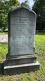
Reverend Thomas Green (b. 1761, d. 1814),[54] the first pastor at the nearby Baptist church, lived at 40 Church.[4]
Cumberland Street
Cumberland Street runs between South Street and Hillside Street, crossing West Elm Street en route.
Captain Joseph Bucknam lived at 3 Cumberland Street, a home built by Jeremiah Loring in 1848.[4]
A Catholic church was built on Cumberland Street in 1879. The location was chosen out of fear that it would be vandalized if it was built on Main Street, for Yarmouth was a prevalently Protestant town at the time. The structure still stands as a private home, having moved to 73-75 Cumberland Street, but it is turned sideways to the street.[51]
East Elm Street
East Elm Street (formerly known as Gooches' Lane) — that is, the eastern half of Elm Street — leads to North Road. It crosses the Royal River at the park just beyond the Fourth Falls and passes Royal Junction at Depot Road.
James Smith lived in the 1801-built number 15.
Andrew Haven and James J. Humphrey lived at the 1835-built number 27. It is a "well-preserved historic duplex with matching attached barn. Retains extensive original historic fabric and all aspects of integrity. Attached, gable-front barn with original windows, clapboards retains all aspects of integrity."[4]
Joel Brooks' pottery, which was located at today's 40 East Elm Street, was in business between 1851 and 1888.
43, 60 and 75 were found to be well-preserved examples of Queen Anne-style residences.[6]
Number 53, "an early-19th century vernacular house, retains windows, door surround, clapboard siding, and overall form."[4]
Across the street, Abner True lived in the cape at number 54 around 1797.
92 East Elm Street was formerly a mill workers’ boarding house, then a maternity hospital.[4]
Hillside Street
Formerly known as Brimstone Hill or Byram's Hill, the Baptist Meeting House stands at the crest of Hillside Street. One of the longest roads in Yarmouth, it connects West Main Street to Greely Road in Cumberland.
48 Hillside was built in 1858, according to one source, while another places it in the 1810s.[4]
Mill Street
Not to be confused with an early name for East Elm Street, today's incarnation used to be the main access road to the mill at the Third Falls.
Henry Caswell, a blacksmith, lived at the brick number 31 Mill Street, across the St. Lawrence and Atlantic Railroad (then the Grand Trunk Railway). His business was directly across the street on what is now greenspace. The house was later owned by the Forest Paper Company for fifty years.[4]
South Street
South Street is off the southern side of Main Street and connects to West Elm Street, either directly or via Cumberland Street. It was laid out in 1848 as part of Yarmouth's first modern housing development.[56] Farm land was given over to house lots and sold to merchants and sea captains, such as Ansel Loring and Perez Blanchard.[40][56]
1 South Street, the former home of Dr. Nat Barker, was built in 1840. He lived there was his wife, Catherine, in the 1930s and 1940s.[48][57]
10 South Street was formerly Alec Mansfield's garage.[4]
Dr. Lewis Whitney built the Greek Revival number 25 in 1849. It was purchased the following year by sea captain Joseph R. Curtis, whose family it remained in until 1983.[4]
Numbers 33 and 37 were originally built jointly; the lot was split in 1858.[4] George W. Springer lived at number 33 after this split.
Ship captain Perez Blanchard lived at number 49.[4]
Frederick Gore (1860–1930), the manager of Forest Paper Company, lived at number 62, at the corner of South and Cumberland Streets, with his wife, Angie.[56][4]
George Coombs, a partner in Coombs Brothers Confectionary Company, lived next door at number 74.[4] In 1909, his brother, Bert, established a Ford dealership on South Street.[58]
West Elm Street
West Elm Street was an early route into Portland, prior to the Presumpscot River being bridged at Martin's Point in Falmouth Foreside, hence one of its former names was "Portland road". It was also known as Chapel Street for a period.
Since West Elm Street was a key stagecoach stop, a large barn was built beside Mitchell's tavern (where Latchstring Park now stands) to house horses.[42]
The house of Richmond Cutter still stands at the southern corner of Church and West Elm Streets.[42]
Two doors further south from Cutter's house, a Methodist church was built in 1898 to mark a revival of the religion. The church was disbanded thirty years later[42] and the building became a meeting place for a fraternal group. The building, now painted yellow, has been converted into a residence.[4]
22 West Elm Street dates to around 1870.[4]
Potters David and Robert Cleaves lived at the Greek Revival number 30.[4]
Mason Reuben Byram lived in the three-story number 36.[4]
Number 43 dates to around 1875.[4]
Jeremiah Loring was the original owner of number 52.[4]
Number 53 dates to the mid-19th century[4]
Reuben Byram built number 58 for his daughter Louisa.[4]
The Greek Revival number 62, whose 1874 barn is accessed from Center Street, dates from the 1840s.[4]
65 West Elm is circa 1850.[4]
At the northwestern corner of the Cumberland Street intersection stands number 73. It was built by Leonard Williams around 1863 and remained in his family for the next ninety years or so.[4]
Captain Alfred Small lived in the 1870s-built number 95.[4]
At the northwestern corner of the intersection with Deering Street stands number 111, designed by John Calvin Stevens and Albert Winslow Cobb for Captain Claudius Lawrence.[4]
West Main Street
West Main Street (still Route 115) leads into North Yarmouth.
The original owner of number 5, the first house on the northern side of West Main, was Captain Samuel Drinkwater in 1803. It later passed to his brother, Captain Joseph Drinkwater.[4]
A hospital, run by Mrs Gilbert, was on the site now occupied by Coastal Manor nursing home at 20 West Main Street. One of the two buildings dates to around 1860; the other around 1835.[4]
A 1973 survey dates number 17, a duplex, to 1807; however, a town assessor says 1860.[4]
27 West Main Street, the Louis P. Pomeroy House, is circa 1890. In 2009, the owner found a shingle signed by Mr. Pomeroy confirming he was the home's builder (additional marking discovered in 2020 on the house front with date May 25, 1889), John Calvin Stevens and Albert Winslow Cobb are confirmed architects via house plans on file at Yarmouth Historical Society. Mr. Pomeroy grew up across the street and eventually built the house. He is also credited with several other projects including the original Town Hall and schools and Main Street Baptist church.[4]
The cape at number 43 was built for yeoman Matthias Storer around 1802.[4]
The Alexander Mills House, at number 54, is circa 1796.[4]
Cyrus Kingsley lived at number 57 around 1865.[4]
A 1973 survey suggests number 60 was built in 1790.[4]
65 West Main Street originates from around 1800.[4]
Deacon Jacob Mitchell lived at number 89. It was later owned by Henry Barbour, who operated a dairy farm.[4]
There are two brick schools at 117 and 121 West Main, just beyond the Sligo Road intersection. The first, the District Number 4 school, was built around 1841 and repaired in the 1890s. In 1847, teacher William Osgood had 74 students; as such, a second school was built beside the original soon after.[59] The second building was likely built around 1856. Both schools closed in 1992, when Harrison Middle School opened.[4]
A large wooden building located at the intersection of West Main Street and Sligo Road, next to the old brick schools, served as the town hall between 1833 and 1910. It was here that the 1849 debates took place that led to Yarmouth's secession from North Yarmouth.[60]
124 West Main Street, which is turned sideways to the road, dates to 1810.[4]
William M.R. Lunt was the original owner of number 139, circa 1856.[4]
Number 154, at the eastern corner of Bates Street, dates to around 1880.[4]
John Cutter, yeoman and grandson of Ammi, was the original occupant of number 163, circa 1795. The house sits at the top of a small hill.[4]
190 West Main, a cape, dates to the early 19th century.[4]
A 1973 survey indicates number 195 was constructed in the 1870s.[4]
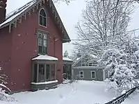
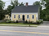
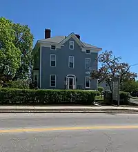
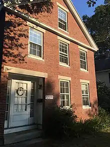
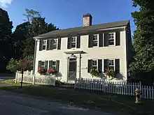
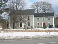
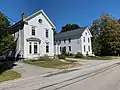
233 West Main Street is an imposing three-story, fifteen-room Italianate mansion that was built for ship captain Reuben Merrill (b. 1818, d. 1875) in 1858.[59] Merrill, who was married to Hannah Elizabeth Blanchard and had four children, was killed while aboard his clipper Champlain when it ran aground near the Farallon Islands, San Francisco.[59] After making sure his crew was safely aboard lifeboats, Merrill was hit by a piece of falling rigging, fell overboard and drowned. Neither Merrill's body nor the ship's haul of railroad iron was ever recovered. His eldest son and first mate, Osborne (b. 1849), witnessed his father's death and never went to sea again, bringing to an end the family's seafaring ways. The home is one of three known surviving works of Portland architect Thomas J. Sparrow.[61][62][63] It was built by John Dunham, a local master builder.[64] In 2011, the Merrill family leased the home to Maine Preservation, a historic preservation organization.[65]
At the eastern corner of the intersection with Fieldstone Drive, number 284, stands a circa-1792 cape. Formerly the home of Nathan Safford.[4]
Mayberry Lane
Mayberry Lane is off the northern section of Portland Street, most visible if coming from the village because it runs at an angle from where the Lindquist Funeral Home stands.
Number 9 dates from around 1837.[4]
Spring Street
The final name of State Route 88 as it passes through Yarmouth, Spring Street runs from the East Main Street split to Route 1 at Cumberland Farms.
The northern section of number 19 was formerly the Spring Street Market.[4]
At the split of Spring Street and East Main Street stands number 20, a former gas station and hair salon.[4]
Number 66 was built in 1807, according to the assessor, or in the 1850s, per the Village Improvement Society.[4]
The cape at number 67 dates to the late 18th or early 19th century.[4] Meanwhile, a survey conducted in the 1970s alleges that number 68, now significantly altered, originates from 1820.[4]
The final home before the western section of Bayview Street, number 114, was originally built on Brown's Point, at the eastern end of Bayview, and moved here in 1868.[4]
Number 141, past Bayview Street on the eastern side of Spring Street, was formerly the site of Frost's gas station.[4] It is now home to a couple of businesses.
Summer Street
A side street off West Main Street, connecting to Bates Street.
A 1973 survey dates 14 Summer Street to the 1880s; a town assessor places it in 1910.[4]
Willow Street
Connects East Main Street to Route 1 opposite the Hannaford plaza.
The first house on the left from East Main Street, number 4, was moved there in 1964 to make way for the parking lot of the Sacred Heart Catholic Church on Main Street[4]
Number 22 was the home of John Fitts.
Horace Stubbs, a carpenter, was the original owner of number 26.[4]
30 Willow Street was moved to this location from near the corner of East Main Street and Yankee Drive, when it was Samuel W. Stubbs' house.[4]
Broad Cove
The area surrounding Broad Cove, at Yarmouth's southern extremity, contains several historic homes amongst newer builds. Gilman Road, which was laid out in 1780 to give access to Larrabee's Landing, is named for the Reverend Tristram Gilman,[66] a New Hampshire native who was the fourth pastor of the nearby Old Ledge Church for forty years – from 1769 until his death. He was the original 1771 occupant of the Gilman Manse house at 463 Lafayette Street, later the home of Merrill Haskell. John Calvin Stevens was hired to undertake the 1905 renovation of the property.[4]
Captain Francis E. Young lived between the two cemeteries. He is buried in the Ledge.
The garrison number 60, built circa 1730 and directly opposite the Pioneer Cemetery, was the former home of the Ledge Church's first minister, Reverend Ammi Ruhamah Cutter. (Cutter was succeeded in the role by Englishman Nicholas Loring, who is buried in the Ledge cemetery.) Perez B. Loring lived there in the mid-19th century. For the second half of the 20th century, it was home to Charles and Anita Stickney, who purchased it from Henry P. Frank.[1] Charles Stickney bought his father's company, Deering Ice Cream, in 1956. It had twenty locations in three states in its peak years.[67] He died in 2008 at the age of 89; Anita died eight years later, aged 90.[68]
120 Gilman Road, near the northeastern corner of the intersection, was built in 1773. Its barn is mid-19th century.[4]
Moving east, crossing Princes Point Road, eight historic homes exist in the stretch leading up to Cousins Island. On the left (number 146) is formerly that of Captain Joseph Drinkwater and his wife, Anna. The house was built in 1844, and his family owned it until 1873. Captain Sumner Drinkwater purchased it in 1902, and it remained in his family until 1979, ending 107 consecutive years of Drinkwater ownership.[4] Next, on the right, is 161, once the home of Samuel Allen Prince. Further down, on the left at 210, opposite the entrance to the Fels-Groves Preserve, is a circa-1817 brick house once inhabited by Captain Reuben Prince (b. 1792, d. 1870) and his wife, Deborah Prince (née Drinkwater; b. 1794, d. 1878), the parents of neighbor Samuel. Upon Reuben's death, the house passed to his son, Harlan, and remained in his family until his death. Arthur and Josie Fels bought the homestead in 1907.
Larrabee's Landing
Three homes exist around the Gilman and Larrabee's Landing Road triangle. First, an 1817-built house on the left, is formerly that of Mrs. Drinkwater. Next, beyond Burbank Lane, at 38 Larrabee's Landing Road, is the former home of Mrs. Bucknam. The original part of the house dates from 1835 and is believed to have been expanded by William Bucknam for his mother. It later became the home of New Hampshire natives Nelson and Fannie Burbank, for whom Burbank Lane was built. They owned and operated Burbank Farm from 1913 to 1936. The house of Charles Bucknam, at number 68, is the final home before Royall Point Road. It was built in 1835.
The only house originally on Royall Point Road was the farmhouse at the current number 70. Nearby Callen Point was where Captain Walter Gendall (d. 1688),[69] an Englishman,[1] was shot while taking supplies to his troops building a fort on the eastern side of the river. There was a wharf which served the farm.
At the end of Barn Road, which is off Highland Farms Road (formerly Vaill Point Road), is Parker Point's (formerly Mann's Point), named for Yarmouth's first inn owner, James Parker (b. 1689, d. 1732).[70] This was home to one of the garrisons set up to protect against Native Indian attacks.
Princes Point
68 Princes Point Road, located just north of Whitcombs Way, is the former schoolhouse of District Number 2. It was converted to a home around 1940.[4]
The 1831-built home at 420 Princes Point Road, a short distance north of the Morton Road intersection, is the former residence of Captain Nicholas Drinkwater, Sr. Captain Sumner Drinkwater (b. 1859, d. 1942) was born in this house.
Mrs. Snell lived at the southeastern corner of the Old Town Landing Road and Morton Road intersection. (Morton Road is named for Harry Newbert Morton, who built the first house on the street.[71] Morton, a lobsterman, moved to Yarmouth in 1929 and remained there until his death at the age of 89.)
A 1944 map shows Bucknam Point Road and the unnamed road slightly to the west that Umpire Way connects to. These are both off Morton Road.[72]
In the early 1880s, Princes Point began to develop as a summer colony. For several years it had become a favorite camping spot for the villagers and the inhabitants of the inland parts of the town who came here for clam bakes and picnics. The town road ended at the John Allen Drinkwater barn, and here a large gate opened into the pasture which included the two points now known as Princes and Sunset Points. Captain Rotheus Drinkwater also had a home a stone's throw away. Captain John Cleaves fenced off a spot on his farm, at today's number 581, for the same purpose.[1]
The first cottage was built in 1884. It was later known as Battery Point Cottage. Others soon built nearby, including Dr. Herbert A. Merrill, Leone R. Cook, George H. Jefferds, Thomas and Nellie Johnston and Wilfred W. Dunn. The first to take up a lot on the western promontory now known as Sunset Point was Samuel O. Carruthers.[1]
In 1894 a wharf was built, and the steamer Madeline made two trips daily from Portland, stopping off at the Cumberland and Falmouth Foresides. The short-lived electric railroad running the same route forced the discontinuation of the service.[1]
In 1899, a four-story hotel of about thirty rooms, named Gem of the Bay, was built on Princes Point by Cornelius Harris.[1] It was destroyed by fire in October 1900 after two seasons in business.[32]
Drinkwater Point
Named for Captain Theophilus Drinkwater, son of Allen and Hannah Drinkwater. His house, built in 1791 by his grandfather, Nicholas, stood at the southern end.[73] Theophilus was married to Louisa Drinkwater. They had three children — Cornelia Amanda, Hannah Gray and Ferdinand.
Captain James Munroe Bucknam's 115-acre farm[74] extended west to where Bucknam Point Road is today. His house is today's number 215, which was built in 1740 and later became the main building of the Homewood Inn development, whose property extended to the north and west. Bucknam wed Caroline Pierce Drinkwater in 1843 and they had five children together — Nicholas, Clarence Leland, Caroline Augusta, Clarence Loraine and James M., Jr. They were married for 26 years, until 1869, Caroline's death. He married for a second time the following year, to Abbie Frances Twombly, with whom he had another two children — Caroline Prince Bucknam and Albion Levi.[75] Nine years after Abbie's death, he married for a third time, to Edna A. Marston, widow of William.
Seaborne Drive and Channel Point Road appeared on a 1944 map of the town, as did the Homewood Inn development,[72] which attracted guests from 1912 to 1992.[2]
Churches
Of the eight churches in Yarmouth, five date from the 19th century or earlier and are listed on the National Register of Historical Places. The oldest remaining church, the North Yarmouth and Freeport Baptist Meetinghouse, was built in 1796.
Three of these historic churches are located on Main Street; they are (from east to west):
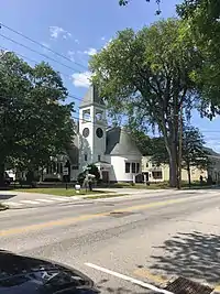
First Universalist
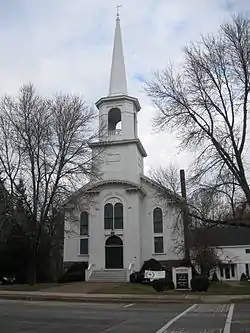
The First Universalist (formerly known as the Central Parish Church) is located at 97 Main Street. It was built in 1860 for an Orthodox Congregational parish, and is one of the state's few surviving churches designed by architect Thomas Holt. It became its current denomination (Unitarian Universalist Association) in 1886. It became listed on the National Register of Historic Places in 1988.[76] The site was formerly occupied by Jenks's Tavern.
First Parish Congregational
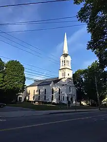
The First Parish Congregational, at 116 Main Street, was built in 1867. It was designed by Portland architect George M. Harding, and it is the third incarnation of churches built for the town's Congregationalists. Charles Augustus Aiken was ordained a pastor here in 1854.
The First Parish Congregational was originally known as the Meeting House Under the Ledge and was located facing Casco Bay at the intersection of Route 88 and Gilman Road. It was built from material floated down the Royal River from the First Falls and hauled up by oxen from Larrabee's Landing (named for Benjamin and Thomas Larrabee, two brothers who settled there in the 1720s), further down Gilman Road towards Cousins Island. The path down to the water still exists. The landing was one of the most important in Yarmouth up until the late 1870s, when erosion caused the whole thing to slide into the channel. The Ledge church, which was founded on November 18, 1730, was torn down in 1836, sixteen years after it was abandoned by the Parish. Yarmouth's early Calvinists fired one minister because he suggested that many people are worthy of salvation. Reverend Tristram Gilman, on the other hand, declared in a sermon that Thomas Jefferson was the Antichrist.[2] Of a settlement that originally contained a school, a tavern and a cemetery of Indian fighters, only the cemetery and the ledge doorstep of the church remain. The weathervane, which was the final addition to the steeple, was mounted in 1838 as a shipping guide on an iron rod atop the ledge overlooking the "Old Ledge" Meeting House by a group of Yarmouth residents. They had raised funds to buy the weathervane from Solomon Winslow, who had removed it from the site after the building's demolition. The weathervane is now on display at the Yarmouth History Center, but its old supports still exist up in the woods beside Route 88. They are passed by the West Side Trail.[77] A second, larger cemetery, known as Ledge Cemetery, was established in 1770.
Tristram Gilman died in 1809. Francis Brown, an 1805 graduate of Dartmouth College and later its president, was invited to preach before the Congregational church. Brown accepted the position of pastor, with the proviso that the church, which had been in use for nearly eighty years, be discontinued.[32] The second church (known as Old Sloop) was built in 1818, at the eastern corner of Main and Bridge Streets (at present-day 121 Main Street), but it was abandoned in 1868 and torn down in 1879. (Lorenzo L. Shaw later lived here in a carriage house, but it burned down in a fire in 1967.) Brown married Elizabeth Gilman, the eldest daughter of his predecessor. Their son was Samuel Gilman Brown. Samuel's son, another Francis Brown, was a theologian.
Those who were against the building of the new church incorporated themselves as the Chapel Religious Society.[32]
The present church was built on the other side of Main Street in 1867 and dedicated the following year. It was added to the National Register of Historic Places in 1995.[78] A plaque commemorating the 275th anniversary of the church was laid on November 18, 2005. The church's steeple is illuminated every night, sometimes in honor of a member or a relative.
First Baptist
The First Baptist Church, at 346 Main Street, was built in 1889. It was designed by John Calvin Stevens.[79]
The other two are:
Cousins Island Chapel
Cousins Island Chapel, at 414 Cousins Street, was built in 1895. It has been holding non-denominational services since 1954 in a former Baptist church.[80] It is listed on the National Register of Historical Places.[8]
Baptist Meeting House
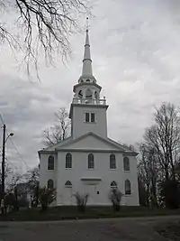
The North Yarmouth and Freeport Baptist Meeting House (known locally as the Old Meeting House or the Meetinghouse on the Hill) at 25 Hillside Street was built in 1796. It has been twice altered: by Samuel Melcher in 1825 and by Anthony Raymond twelve years later. It ceased being used as a church in 1889, when its congregation moved to the structure now on Main Street. The 1805 bell was transferred to the new home. The meeting house was unused for less than a year. It was purchased for $1,000 and converted into the town's first library and antiquarian society and known as Yarmouth Memorial Hall. It was donated to the town in 1910 and used for town meetings until 1946, at which point they were moved to the Log Cabin on Main Street. During World War II, the belfry was used an airplane-spotting outlook post in the Civil Defense System. Twelve townsfolk per day manned the tower in two-hour shifts. In 1946, the Village Improvement Society (founded in 1911) agreed to maintain the interior of the meeting house. In 2001, the town and the society restored the building, from its granite foundation to the barrel-vaulted ceiling. A non-denominational church service is held here during the town's Clam Festival.[81] The building is owned by the Yarmouth Village Improvement Society and is listed on the National Register of Historic Places.[8]
Gallery
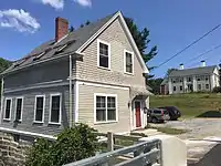
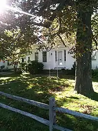
 37 and 33 South Street. The buildings were originally built connected to each other but were later separated
See also
References
- Ancient North Yarmouth and Yarmouth, Maine 1636-1936: A History, William Hutchison Rowe (1937)
- Images of America: Yarmouth, Hall, Alan M., Arcadia (2002)
- "Do You Know...About Yarmouth's Historic Properties?" - Yarmouth Historical Society, March 2020
- Architectural Survey Yarmouth, ME (Phase One, September, 2018 - Yarmouth's town website)
- MHPCPC at MaineStateMuseum.org
- "Project Report Reconnaissance-Level Architectural Survey of Yarmouth, ME MHPC Project ID# YPI2018 Phase One – 2018" - Town of Yarmouth website
- [CHAPTER 701, ZONING ORDINANCE, Town of Yarmouth, Maine - Town of Yarmouth official website
- Yarmouth Historical Society: The National Register of Historic Places
- "Dictionary of Irish Architects 1720 - 1940"
- 90 Main Street, Yarmouth, ME 04096 - Realty of Maine
- Reminiscences of a Yarmouth Schoolboy, Edward Clarence Plummer (Marks Printing House, 1926)
- "Item 20925 - Oxford Hotel fire, Skowhegan, 1908" - Vintage Maine Images
- The Bulletin of Pharmacy, volume XX, January to December 1906
- Images of America: Yarmouth, Alan M. Hall (Arcadia, 2002), p.10
- Images of America: Yarmouth, Alan M. Hall (Arcadia, 2002), p.19
- Images of America: Yarmouth, Alan M. Hall (Arcadia, 2002), p.12
- Images of America: Yarmouth, Alan M. Hall (Arcadia, 2002), p.16
- Portland Board of Trade Journal, volume 3
- Images of America: Yarmouth, Alan M. Hall (Arcadia, 2002), p.20
- 132 Bridge Street, Yarmouth, ME 04096 - Redfin
- "Yarmouth is looking to reconnect itself" - Portland Press Herald, August 2, 2012
- 71 Pleasant Street, Yarmouth, ME 04096 - Redfin
- Images of America: Yarmouth, Alan M. Hall (Arcadia, 2002), p.15
- Old Times in North Yarmouth, Maine
- Kim, Susanna (October 24, 2012). "The Wealthiest Person in Each State". ABC News. Retrieved 24 October 2012.
- Short, Kevin (July 31, 2014). "Here Is The Richest Person In Each State". The Huffington Post. Retrieved 31 July 2014.
- Images of America: Yarmouth, Alan M. Hall (Arcadia, 2002), p.37
- Images of America: Yarmouth, Alan M. Hall (Arcadia, 2002), p.17
- Images of America: Yarmouth, Alan M. Hall (Arcadia, 2002), p.39
- Images of America: Yarmouth, Alan M. Hall (Arcadia, 2002), p.41
- Images of America: Yarmouth, Alan M. Hall (Arcadia, 2002), p.42
- Yarmouth Revisited, Amy Aldredge
- Images of America: Yarmouth, Alan M. Hall (Arcadia, 2002), p.43
- Images of America: Yarmouth, Alan M. Hall (Arcadia, 2002), p.38
- "Arsonist could get 20 years in prison" Archived 2012-07-30 at Archive.today - Portland Press Herald, November 12, 2009
- "Arsonist to serve 11 years, pay $3.7M to businesses displaced in Yarmouth, York" Archived 2011-07-19 at the Wayback Machine - The Forecaster, November 12, 2009
- Images of America: Yarmouth, Alan M. Hall (Arcadia, 2002), p.44
- According to a plaque inside the store
- Images of America: Yarmouth, Alan M. Hall (Arcadia, 2002), p.26
- Cemetery Records at YarmouthMEHistory.org
- Old Times in North Yarmouth, Maine, p. 758
- Images of America: Yarmouth, Alan M. Hall (Arcadia, 2002), p.33
- Images of America: Yarmouth, Alan M. Hall (Arcadia, 2002), p.32
- Images of America: Yarmouth, Alan M. Hall (Arcadia, 2002), p.31
- Images of America: Yarmouth, Alan M. Hall (Arcadia, 2002), p.30
- "New owners plan to transform Andy’s Handy Store in Yarmouth" - Portland Press Herald, December 16, 2014
- Images of America: Yarmouth, Alan M. Hall (Arcadia, 2002), p.21
- Images of America: Yarmouth, Alan M. Hall (Arcadia, 2002), p.27
- SmithsGeneral.com - About
- "Yarmouth gives developers OK to raze Main Street building, first step in mixed-use project" - MaineBiz, August 27 2020
- Images of America: Yarmouth, Alan M. Hall (Arcadia, 2002), p.25
- Aftermath of fire at Bernstein's Store, Yarmouth, 1913 - Maine Memory Network
- "Yarmouth seeks proposals for historic fire station" - The Forecaster, June 28, 2017
- "Rev Thomas Green" - Georgetown Historical Society
- Early New England Potters and Their Wares, Lura Woodside Watkins - Google Books
- Images of America: Yarmouth, Alan M. Hall (Arcadia, 2002), p.24
- 1 South St, Yarmouth, ME 04096 - Redfin
- Images of America: Yarmouth, Alan M. Hall (Arcadia, 2002), p.23
- Images of America: Yarmouth, Alan M. Hall (Arcadia, 2002), p.36
- Images of America: Yarmouth, Alan M. Hall (Arcadia, 2002), p.8
- Bouchard, Kelley (September 16, 2011). "History comes out of hiding". Portland Press Herald. Retrieved 9 December 2011.
- "National Register Properties - Historical Society and Museum - Town of Yarmouth, Maine". Retrieved 9 December 2011.
- Bouchard, Kelley (July 1, 2011). "The house that Reuben built". The Portland Press Herald / Maine Sunday Telegram. Retrieved 9 December 2011.
- "NRHP nomination for Captain Reuben Merrill House". National Park Service. Retrieved 2016-01-10.
- "The house that Reuben built" - Portland Press Herald, July 1, 2011
- "Gilman, Tristram, 1735-1809. Tristram Gilman sermons and other papers, 1728-1808: Guide" Archived 2018-07-03 at the Wayback Machine - Harvard University Library
- "Charles E. "Stick" Stickney Jr. Obituary" - Portland Press Herald, December 8, 2011
- "ANITA (COOPER) STICKNEY" - Legacy.com
- "Captain Walter Gendall: A Biographical Sketch" - Doctor Charles E. Banks (1880)
- "Colonial Tavern Keepers"
- "Evelyn Yates Obituary - Yarmouth, ME | Portland Press Herald/Maine Sunday Telegram" - Portland Press Herald, March 29, 2017
- 1944 map of the area hosted on University of New Hampshire's servers
- "Old Times: a magazine devoted to the preservation and publication of documents relating to the early history of North Yarmouth, Maine"
- "Cumberland County, Maine - Captain James Monroe Bucknam" - Raynorshyn.com
- "Genealogical and Family History of the STATE OF MAINE" - DunhamWilcox.net
- "National Register Information System". National Register of Historic Places. National Park Service. March 13, 2009.
- "About the Weathervane" - Yarmouth Historical Society's website
- "Our History - First Parish Congregational Church". Archived from the original on 2010-09-11. Retrieved 2009-10-17.
- Images of America: Yarmouth, Alan M. Hall (Arcadia, 2002), p.28
- "Is there room in Yarmouth for a new church congregation?" - Bangor Daily News, April 23, 2015
- "Steeplejacks nail high spire act" - Portland Press Herald, September 22, 2011