Maine State Route 88
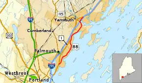
State Route 88 (SR 88) is a state highway in southern Maine, United States. It runs south to north for 8.37 miles (13.47 km), from U.S. Route 1 (US 1) in Falmouth to US 1 in Yarmouth. It runs to the east of US 1, and its speed limit is 35 miles per hour (56 km/h). Over its course, its furthest distance from US 1 is about 1⁄2 mile (0.80 km). This occurs in its Falmouth Foreside section.
| ||||
|---|---|---|---|---|
 | ||||
| Route information | ||||
| Maintained by MaineDOT | ||||
| Length | 8.37 mi[1] (13.47 km) | |||
| Major junctions | ||||
| South end | ||||
| North end | ||||
| Location | ||||
| Counties | Cumberland | |||
| Highway system | ||||
| ||||

Route description

The route is connected to US 1 directly at SR 88's two termini. It is also connected to US 1 indirectly, by a ramp, via Tuttle Road in Cumberland Foreside. Its name changes four times en route. It is Foreside Road between the southern terminus and the Yarmouth town line, at which point it becomes Lafayette Street. It then becomes East Main Street just before the Royal River's First Falls, before finishing as Spring Street.
"Herbie", New England's oldest and largest elm tree for the final thirteen years of its existence, stood on Route 88 (East Main Street) in Yarmouth, at its intersection with Yankee Drive, between 1793 and 2010.
SR 88 is mostly residential, although businesses are located on it at several points. These include (heading northward) Portland Country Club, Skillins garden center and The Dockside Grill (all in Falmouth); Town Landing Market (which was once featured in a national Coca-Cola television commercial) (Falmouth Foreside); and the Lower Falls Landing plaza (Yarmouth). Each of these examples are situated on the northbound (eastern) side of the highway.[2]
Junction list
The entire route is in Cumberland County.
| Location | mi[1] | km | Destinations | Notes | |
|---|---|---|---|---|---|
| Falmouth | 0.00 | 0.00 | |||
| Yarmouth | 7.52 | 12.10 | Eastern terminus of SR 115 | ||
| 8.37 | 13.47 | ||||
| 1.000 mi = 1.609 km; 1.000 km = 0.621 mi | |||||
References
- "Maine DOT Map Viewer". Maine Office of GIS. Retrieved July 11, 2017.
- Google (July 11, 2017). "Maine State Route 88" (Map). Google Maps. Google. Retrieved July 11, 2017.
External links
 Media related to Maine State Route 88 at Wikimedia Commons
- Floodgap Roadgap's RoadsAroundME: Maine State Route 88
