History of Yarmouth, Maine
The history of Yarmouth, Maine, is closely tied to its position on the banks of the Royal River and its proximity to Casco Bay, an inlet of the Gulf of Maine, itself a gulf of the Atlantic Ocean.
Native Americans originally settled the area, and several wars between them and later European settlers occurred before they were driven from the area for the final time in the mid-18th century.
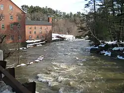
Around three hundred sea-going vessels were built in Yarmouth harbor's shipyards from around 1790 to 1890, while almost sixty mills were founded over 250 years along the town's section of the Royal River, making use of its four waterfalls for power.
The Maine Historic Preservation Commission[1] has found many of Yarmouth's historic buildings eligible for listing on the National Register of Historic Places,[2] in addition to the twelve that are already included.
Early settlers

Traces of human occupation in the Yarmouth area date to about 2,000 BC. During the years prior to the arrival of the Europeans, many Native American cultures existed in the area,[3] largely because of the natural features of the coastal land. Rivers provided several resources, including food, fertile soil, power for the mills and the navigability between the inland areas and the ocean.[4]
In 1640, a 31-year-old Englishman, George Felt, who had emigrated to Charlestown, Massachusetts, eleven years earlier, purchased 300 acres of land at Broad Cove from John Phillips (b. 1607, d. c. 1667), a Welshman, and in 1643 became one of the first European settlers in Yarmouth. (His family in Bedfordshire, England, went by the family name Felce. He called himself George Felch, however, when he moved to America. He began to be known as George Felt in his later years.)
In 1630, Felt married 29-year-old Elizabeth Wilkinson, with whom he had six children: Elizabeth, George Jr., Mary, Moses I, Aaron and Moses II. Around 1649, the family moved back to Malden, Massachusetts, just as it was being incorporated into a city. They returned to Casco Bay in 1667, shortly after which Felt bought two thousand more acres of land from Phillips. In 1684, Felt moved back to Massachusetts. He died in Malden, aged about 84, with Elizabeth surviving him by only on year. The couple had become the first citizens of Malden to receive town aid, such was their fall from wealth during the latter stages of their time in Maine.
Englishman William Royall (b. 1580, d. 1676),[5] a cooper, emigrated to Salem, Massachusetts, in July 1629, aboard the Lyon's Whelp. He was a servant in the Massachusetts Bay Colony Company, and after serving his seven years, he was provided with a land grant in the Casco Bay area of Maine. In 1636, he purchased a farm at what is now the upscale Lambert Point, next to Redding Creek, at the southern tip of Lambert Road, where he lived with his wife, County Durham native Phoebe Green. They had thirteen children together between 1639 and 1657, the first being son William Jr.
The Royal River has ever-since borne Royall Sr.'s name, minus the second L, though two streets off Gilman Road — Royall Meadow Road and Royall Point Road — carry the original spelling. (One of the earliest maps naming the river Royal was a 1699 map by Wolfgang William Romer on which it was spelled "Roiall River.")[5] This stream and its vicinity were called by the Indians "Westcustogo" — a name that, until the early 1990s, was preserved by an inn of the same name on Princes Point Road at its intersection with Lafayette Street.[6] (The building remains but it is now occupied by another business.)
Royall's family moved to Dorchester, Massachusetts, in 1675, a year before William Sr.'s death. (He was able to see Isaac, son of William Jr. and one of his four grandchildren, born in 1672 before they moved south. Isaac Royall Jr. went on to become his great-grandson.) Following in his grandfather's footsteps, some eighty years after the fact, Isaac's brother, Sam Royall, moved to Yarmouth sometime after 1724. He died in the town in 1784. His son, Elijah, followed six years later.
John Cousins (b. circa 1596, d. 1682), a native of Wiltshire, England, had arrived a year or more earlier than Royall, with his wife, Mary, occupying the neck of land between the branches of the stream which has since taken his last name, and owning the island now also so-named. Their son, Isaac,[7] emigrated from Wiltshire in 1647, aged about 34, arriving with his new wife, Elizabeth.[7]
By 1676, approximately sixty-five people lived in Westcustogo. Soon after, however, conflicts forged by King Philip's War caused them to abandon their homes and move south.[3] John Cousins was injured and went to York, Maine, to receive treatment. He died in Cider Hill, York County, in 1682, aged 86. He deeded his real estate in Casco Bay to his wife.[8]
Also in 1676, Mussel Cove resident George Felt Jr. was killed on Peaks Island during the conflicts.[9][10] Felt's wife of fourteen years, Londoner Phillippa Andrews, moved to Salem, Massachusetts, where she married twice (to Samuel Platt in 1682 and Thomas Nelson in 1690) before her death in 1709. She had emigrated to America with her parents in 1635.
Some settlers returned to their dwellings in 1679, and within twelve months the region became incorporated as North Yarmouth, the eighth town of the province of Maine.[8]
In 1684, an English developer named Walter Gendall claimed to own all of Felt's two thousand acres in Casco Bay. He had purchased one hundred acres from him in 1680.[11] Gendall had emigrated to America around 1640.[11]
In 1688, while the inhabitants on the eastern side of the river were building a garrison, they were attacked by Indians, and attempted a defense. They continued the contest until nightfall, when the Indians retired. It was not long before they appeared again, in such force that the thirty-six families of the settlement were forced to flee, abandoning their homes for a second time.
The unrest kept the area deserted for many years, but by 1715 settlers revisited their homes, by which point they found their fields and the sites of their habitations covered by a young growth of trees. The mills at the First Falls were rebuilt first.[8]
In 1722, a "Committee for the Resettlement of North Yarmouth" was formed in Boston, Massachusetts.
In 1725, Massachusetts natives William and Matthew Scales were killed at the hands of the Indians. William's wife and daughter, both named Susannah, survived. His daughter married James Buxton the same year. They are both buried in the Ledge Cemetery.
Joseph Felt, son of Moses Felt II, also perished. His wife, Sarah (Mills), and children were taken into captivity for five years. One of the captors remarked to Felt's widow: "Husband much tough man! Shot good many times, no die! Take scalp off alive; then take knife and cut neck long 'round."[12] Joseph Felt's daughter and George Felt's great-granddaughter, Sarah, married in 1720 Captain Peter Weare, who recovered the family in some woods near Quebec. He later drowned while crossing the river near his home. The captain's son and Joseph Felt's brother-in-law, Joseph Weare, became a noted scout, pursuing the Native Americans at every opportunity until his death during a trip to Boston sometime after 1774. His widow, Mary Noyes, remarried, to Humphrey Merrill of Falmouth.
Once resettlement began, in 1727, the town's population began to grow rapidly. A proprietors' map was drawn up. It surveyed land divisions made with 103 original proprietors, each with a home lot of ten acres. If this lot was occupied and improved, the settler was permitted to apply for larger after-divisions.
The structural frame of the first meeting house was raised in 1729 near Westcustogo Hill on what is now Gilman Road, and nine years later the first school was built at the northwestern corner of the Princes Point Road intersection.
North Yarmouth held its first town meeting on May 14, 1733.
In August 1746, a party of thirty-two Indians secreted themselves near the Lower Falls for the apparent purpose of surprising Weare's garrison, in the process killing 35-year-old Philip Greely, whose barking dog blew their cover.[8] His wife was Hannah. Their son, Captain Jonathan Greeley, died in an engagement with a British frigate off Marblehead, Massachusetts, in 1781. He was 39. Hannah remarried, to Jonathan Underwood.
In June 1748,[13] a large party of Indians surprised four people near the Ledge meeting house. They killed the elderly Ebenezer Eaton.[8]
Joseph Burnell was the only inhabitant of the town to be killed at the hands of the Indians in 1751. He had been on horseback near the Presumpscot River falls when he was ambushed and shot. He was found scalped, with his steed lying nearby, having been shot four times.[8] He left behind a wife and 14-year-old daughter, both named Sarah.
In 1756, Indians attacked the Means family, who lived at Flying Point. The family consisted of Thomas, his wife Alice, daughters Alice and Jane,[14] an infant son, Robert, and Molly Finney, sister of the patriarch and aged about sixteen. The family was dragged out of their home. Thomas was shot and scalped. Mother and baby ran back into the house and barricaded the door. One of the attackers shot through a hole in the wall, killing the infant and puncturing his mother's breast. John Martin, who had been sleeping in another room, fired at them, causing them to flee. They took with them Molly, whom they made follow them through the woods to Canada. Upon her arrival in Quebec, she was sold as a slave. A few months later, Captain William McLellan, of Falmouth, was in Quebec in charge of a group of prisoners for exchange. He had known Molly before her capture and secretly arranged for her escape. He came below her window and threw her a rope which she slid down. McLellan brought her back to Falmouth on his vessel. They married shortly afterwards.[8] Alice remarried, to Colonel George Rogers. Thomas is interred in Freeport's First Parish Cemetery, alongside his son. His wife is buried with her second husband in Flying Point Cemetery.
The Means massacre was the last act of resistance by the indigenous people to occur within the limits of the town.[8]
By 1764, 1,098 individuals lived in 154 houses. By 1810, the population was 3,295. During a time of peace, settlement began to relocate along the coast and inland.[3]
The town's Main Street gradually became divided into the Upper Village (also known as the Corner) and Lower Falls, the split roughly located around the present-day U.S. Route 1 overpass (Brickyard Hollow, as it was known). Among the new proprietors at the time were descendants of the Plymouth Pilgrims.
The Yarmouth Village Improvement Society has added wooden plaques to over 100 notable buildings in town. These include:[15][16]
- Cushing and Hannah Prince House, 189 Greely Road — built 1785. This Federal-style farmhouse remained the home of several generations of the Levi and Olive Prince Blanchard family from 1832 to 1912
- Mitchell House, 333 Main Street — circa 1800. Another Federal-style building, with an unusual steeply-pitched hip roof, it was the home of two doctors — Ammi Mitchell, who died "suddenly" in 1823, aged about 61[17] and Eleazer Burbank. Eleazer married Sophronia Burbank. Their son, Dr. Augustus Hannibal Burbank (b. 1823, d. 1895),[18] was treasurer of Yarmouth Aqueduct Company.[19] He graduated from Bowdoin College in 1843 and studied medicine at Harvard University, receiving his MD in 1847. He returned to Yarmouth and entered general practice. He married Elizabeth Richardson Banks, who died in 1869. (Their infant daughter died in 1873.) Two years later, he married Alice Noyes Thompson.[20] Three years after Augustus died, Alice, in turn, remarried, to Charles Torrey. He died in 1918 while they were living in Plymouth, Massachusetts, after which Alice returned to Yarmouth, where she died twenty years later, aged about 90. Augustus was an early president of North Yarmouth Academy, while Charles Chesley Springer was a principal
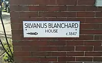
- Capt. S. C. Blanchard House, 317 Main Street — 1855. One of the most elaborate and finely-detailed Italianate residences on the Maine coast, it was built by Sylvanus Blanchard (b. 1778, d. 1858),[21] a highly successful shipbuilder. The design is by Charles A. Alexander, who also executed the Chestnut Street Methodist Church in Portland. It replaced a building that is pictured in the oldest image (a drawing) of a Yarmouth street scene, drawn between 1837 and 1855[22]
- Captain Rueben Merrill House, 233 West Main Street — 1858. Thomas J. Sparrow, the first native Portland architect, designed this three-story Italian-style house. Merrill was a well-known sea captain, who went down with his ship off San Francisco in 1875. Few changes have been made in the building, because it did not leave the possession of the Merrill family between then and 2011
Another notable building is Camp Hammond (1889–90), at 275 Main Street, whose construction method is significant in that the building consists of a single exterior wall of heavy planks over timbers, with no hidden spaces or hollow walls. This so-called mill-built construction was used largely for fire prevention.[15] It was built by George Warren Hammond. Frederick Law Olmsted, who designed Central Park in New York, designed the landscape for the exterior.[23]
A "grasshopper plague" arrived in 1822, which resulted in the loss of wheat and corn crops.[8]
Around 1847, the Old Ledge School was moved from Gilman Road to today's Route 88, at the foot of the hill where the West Side Trail crosses the road. A 1975 replica now stands just beyond the brick schools on West Main Street.
Secession from North Yarmouth
Yarmouth constituted the eastern part of North Yarmouth until 1849, when it seceded and incorporated as an independent town. The split occurred due to bickering between the inland, farming-based contingent and the coastal maritime-oriented community. Unable to resolve this difference, the two halves of the town separated into present-day Yarmouth and North Yarmouth.[3]
In 1849 there were nine districts in Yarmouth, designated by numbers: Number One: (Cousins) Island; Number Two: Ledge; Number Three: (Lower) Falls; Number Four: Corner; Number Five: (Princes) Point; Number Six: Greely Road; Number Seven: Pratt; Number Eight: Sweetser; and Number Nine: East (Main). By 1874, however, efforts were made to abolish this setup due its being seen as "unfair" in terms of fund distribution.[8]
By 1850, Yarmouth's population was 2,144, and very little changed over the hundred years that followed.

18th- and 19th-century business relied heavily upon a variety of natural resources. Once lumber was cut and sent to market, the land was farmed. Tanneries were built near brooks; potteries and brickyards put to use the natural clay in the area; and mills flourished along the Royal River, providing services such as iron-forging and fulling cloth.[3]
Shipbuilding
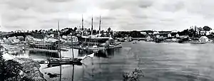
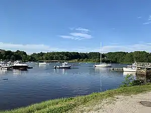
Maritime activities were important from the beginning of the third settlement. Almost three hundred vessels were launched by Yarmouth's shipyards in the century between 1790 and 1890.[24] Lumber from inland areas was shipped out from the harbor. Vessels were being built by 1740, and by 1818 shipbuilding in the area was in full swing, though Yarmouth's industry peaked in the 1870s, and declined rapidly shortly thereafter. Four major shipyards built vessels during this period. On the western side of the river, Henry Hutchins and Edward J. Stubbs operated from 1851 to 1884. Sylvanus Blanchard and his three sons owned the Blanchard Brothers shipyard on Union Wharf.[25] Lyman Fessenden Walker's (b. 1836, d. 1920) shipyard launched forty vessels of all sizes. (Walker lived in the brick building at 51 Pleasant Street.)[23] On the eastern side of the river, Giles Loring had a shipyard. It was here that the final large sailing vessel was built, in 1890.[3] Today, there are just two boatyards, one on either side of Lower Falls Landing: Yarmouth Boatyard (formerly Union Wharf; established in 1948; located almost beneath the northbound lanes of Interstate 295) and Yankee Marina (established in 1964; whose entrance is near the crest of the Route 88 hill).
19th century Yarmouth
In 1887, a fire started in the dry grass south of Grand Trunk Station by a spark from a passing train. Fanned by a strong wind, it spread rapidly into the woods and up over the ledge. Two hundred acres were burned, and the fire was only stopped because it reached the waters of Broad Cove.[8]
Yarmouth's "town system"[8] went into effect in April 1889. Three of the former districts were discontinued because they were small and had dilapidated buildings. These were Princes Point, Greely Road and the Sweetser district – the last of which was on the Sodom Road (now Granite Street) and the Freeport line.[8]
Electricity came to Yarmouth in 1893.[23]
Into the 20th century
Another, more menacing fire occurred in April 1900, when the corn-canning factory of Asa York caught from a spark blown from the stack of the Walker & Cleaves sawmill. A strong southerly breeze carried the sparks directly across the most thickly-settled part of town, causing small fires in various places so that over twenty buildings were burning concurrently.[8]
In 1903, the post office established a route around town for the rural free delivery of mail. Hired was Joshua Adams Drinkwater as the town's first letter carrier. Early in the morning he would leave Princes Point, pick up the mail at Lower Falls, and then deliver letters to the northern edge of town, including Sligo and Mountfort Roads. Around noon, he would pick up the afternoon sack for the town's western and coastal farms. Each day, as he passed his farm on Princes Point Road, he would change horses and eat lunch with his wife, Harriet.[26] They had a daughter, Elizabeth.
In 1918, the Spanish flu hit town in two waves, resulting in 370 cases and 14 deaths.[23]
In 1923, town historian William H. Rowe announced that a history of Yarmouth was in the works. The project took thirteen more years to complete, but it was "so thorough that it is still in print".[24] Rowe died in 1955, aged about 73.
In 1949, Yarmouth celebrated its centenary with a parade.[27]
Rapid growth was experienced again around 1948 when Route 1 was put through the town. Two years later, there were 2,699 inhabitants of the town. Interstate 295 was built through the harbor in 1961 (spanning part of the harbor known as Grantville[28] across to the land between Route 88 and Old Shipyard Road), and the town grew about 40%, from 4,854 residents in 1970 to 8,300 thirty-five years later.
New millennium
As of the early 20th century, Yarmouth is mostly residential in character, with commercial development scattered throughout the town, particularly along Route 1 and Main Street (State Route 115).
References
- MHPCPC at MaineStateMuseum.org
- Architectural Survey Yarmouth, ME (Phase One, September, 2018 - Yarmouth's town website)
- Yarmouth Historical Society, via the Yarmouth/North Yarmouth Community Guide, Portland Press Herald, Summer 2007
- "Ancient North Yarmouth and Yarmouth" - Yarmouth Historical Society
- "Muddy Waters", Portland Magazine (June 2020)
- Westcustogo Inn
- "Cousins Make Mark on Maine" - banfield-hodgkinsfamily.com
- Ancient North Yarmouth and Yarmouth, Maine 1636-1936: A History, William Hutchison Rowe (1937)
- "A History of Peaks Island and Its People. Also A Short History of House Island, Portland, Maine" - Nathan Goold (1897)
- "The family of man"
- Captain Walter Gendall, of North Yarmouth, Maine: A Biographical Sketch, Doctor Charles E. Banks (1880) - HathiTrust
- History of Cumberland County, Maine: Town of Cumberland, Everts & Peck, 1880
- North Yarmouth Necrology, 1736–1762 - Rev. Amasa Loring
- "Maine Ulster Scots Project" - Facebook, May 6, 2016
- Maine's Historic Places, Frank Beard (1982)
- Yarmouth Historical Society: The National Register of Historic Places
- The Congregational Quarterly, Volume 13
- "Harvard Medical Alumni Bulletin, Volumes 1-6"
- Water Works History - "Yarmouth, Maine"
- "A Biographical Dictionary of Contemporary American Physicians and Surgeons"
- Cemetery Records at YarmouthMEHistory.org
- Images of America: Yarmouth, Alan M. Hall (Arcadia, 2002), p.6
- Yarmouth Revisited, Amy Aldredge
- Images of America: Yarmouth, Hall, Alan M., Arcadia (2002)
- "Back Then" - Fishermen's Voice
- Images of America: Yarmouth, Alan M. Hall (Arcadia, 2002), p.11
- Images of America: Yarmouth, Alan M. Hall (Arcadia, 2002), p.23
- "Edna May Morrill Obituary" - Legacy.com, August 22, 2007