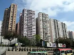
Ho Man Tin
Ho Man Tin (Chinese: 何文田; Jyutping: ho4 man4 tin4; Cantonese Yale: hòh màhn tìhn) is a mostly residential area in Kowloon, Hong Kong, part of the Kowloon City District.
| Ho Man Tin | |||||||||||||||
|---|---|---|---|---|---|---|---|---|---|---|---|---|---|---|---|
 Ho Man Tin Residential | |||||||||||||||
| Chinese | 何文田 | ||||||||||||||
| Cantonese Yale | Hòh màhn tìhn | ||||||||||||||
| |||||||||||||||

History
Section of lists of villages in the book Xin'an Xianzhi (literally The History of Xin'an County) published in twenty fourth year of Jiaqing era (A.D. 1819) did not have any record of Ho Man Tin. The original Ho Man Tin was quite different from today's Ho Man Tin. It was located in the heart of nowaday Mong Kok. With cultivated lands, it was surrounded in the north by Argyle Street, west by Coronation Road (present-day Nathan Road), and east by Quarry Hill, No. 12 Hill and Tai Shek Kwu (present-day Kadoorie Hill). Southeast from its original location is Fo Pang and to the south Mong Kok. Streams from those hills in the east offered water for cultivation, the latter reflected in the area's name last Chinese character, i.e. tin, 田, which means field. The "Ho" (何) and "Man" (文) part of the name are both Chinese surnames; so Ho Man Tin represents the agricultural land owned by the "Ho" and "Man", the major families who took their residence around the area.
In the 1950s and 1960s, the eastern hills to the original site of Ho Man Tin became a resettlement area for refugees from China, the city building there the Ho Man Tin Estate, which gave the name Ho Man Tin to that section of the hills, thus shifting away name-wise from the original flat fields. The present-day Ho Man Tin is close to Argyle Street and Kowloon Hospital. The area is within the district of the Kowloon City police station.
Today, Ho Man Tin is home to many public housing estates as well as the headquarters of the Housing Authority. Oi Man Estate was on the itinerary of Queen Elizabeth II when she visited Hong Kong in 1975.
Streets and places in Ho Man Tin
- Ho Man Tin Hill
- Peace Ave.
- Perth Street
- Princess Margaret Road
- Pui Ching Road
- Soares Ave.
- Victory Ave.
- Waterloo Hill
Community facilities
- Perth Street Sports Ground
Public services
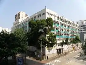
- Kowloon Public Library
- Kowloon Hospital
- Kowloon Rehabilitation Centre
- Hong Kong Housing Authority Headquarters
Education
Educational institutions in Ho Man Tin include:
- The Open University of Hong Kong
- Homantin Government Secondary School
- King George V School
- Kowloon Junior School
- Pentecostal School
- Pui Ching Middle School
- Shun Tak Fraternal Association Seaward Woo College
- St. Teresa Secondary School
- Workers' Children Secondary School
- Yu Chun Kueng Memorial College
Transportation
Princess Margaret Road, Waterloo Road, Argyle Street and Pui Ching Road act as the main arteries of the Ho Man Tin area, and it is conveniently served by public buses.
Ho Man Tin Station of the Mass Transit Railway (MTR) is located in the southern portion of the area, near Hung Hom. It takes 10 to 15 minutes walk between the station and major Ho Man Tin district such as Oi Man Estate, Ho Man Tin Estate and Ho Man Tin Plaza.
External links
| Wikimedia Commons has media related to Ho Man Tin. |